In brief: A robust front will bring much drier air into the Houston region today, and a couple of chilly nights in the upper 40s. After that Houston will likely experience warmer weather for the rest of March: think 80s with some humidity rather than the 70s we’ve had for much of the month. Summer is not here, but it is on the horizon.
Wednesday
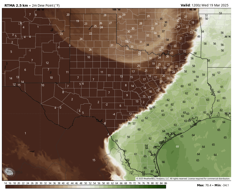
Temperatures across much of the metro area this morning are in the range of 65 to 70 degrees, which is rather warm for mid-March. It’s also fairly sticky outside. However, this will end later this morning, as a fairly strong front moves into the area. We’ll feel this both in the form of northwesterly winds, gusting up to 20 or 25 mph, as well as much drier air. As skies clear out later today, with the drier air, expect high temperatures in the vicinity of 80 degrees.

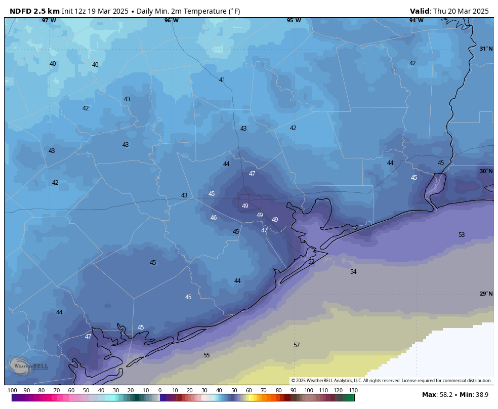
Unfortunately for rodeo-goers, those winds will not let up much this evening. In fact, they should peak during the overnight hours, perhaps gusting up to about 30 mph. So be prepared for that. Temperatures after the show will be in the 60s, before lows tonight ultimately drop into the mid- to upper 40s for much of the metro area away from the coast.
Thursday
This will be a sunny and pleasant day, with low humidity and highs of around 70 degrees. During the morning hours, at least, we should still see some modestly gusty winds. However by the afternoon these winds will likely slacken. Thursday night will be chilly again, with much of the region likely dropping into the upper 40s. Will this be the last time that parts of the Houston region get into the 40s this season? I think that’s quite possible.
Friday
Expect a sunny, pleasant day with highs in the mid-70s. Winds will turn southerly, gusting at times up to 20 mph. Expect overnight lows to only reach about 60 degrees with the warmer, southerly flow.
Saturday
The first half of the weekend brings more sunshine, with highs around 80 degrees. Dewpoints should still be in the 50s, so it will not feel too humid outside. Yet. Lows on Saturday night only drop into the mid-60s.
Sunday, Monday, and next week
With a more humid flow, expect temperatures to reach into the lower- to mid-80s on Sunday with likely increasing cloudiness. The question then is to what extent a slug of drier air will slide down from the northeast into the region. This is known as a “backdoor” front because instead of blowing down from the northwest, it edges in from the northeast. It’s likely that this system will generate a decent chance of rain, perhaps on the order of 50 percent during the period of Sunday afternoon through Monday morning. Accumulations don’t look that high, probably on the order of tenths of an inch.
Temperatures on Monday and Tuesday will depend on the extent to which the backdoor opens, and the amount of cooler and drier air that moves in. Perhaps we’ll have a couple of days in the 70s, with lows in the upper 50s. Maybe it will be a tad warmer. Most of the rest of next week should see highs in the 80s, however, with a decent amount of humidity. So it goes in Houston as we get nearer the end of March: fewer fronts and more humidity.

/puke emoji/
Yeah. Like sticky oatmeal air.
“Summer is not here, but it is on the horizon”
But; but; but; but Spring is beginning tomorrow……….
1!:~D}
A little off topic here but It’s been 100 years since the Tri State Tornado disaster of 1925. I would recommend researching that event. It was the most apocalyptic tornado event in history.
Or we could research the ides of march?
That’s because we don’t get spring or fall here anymore. We get a couple of weeks of moderate temperatures in between summer and winter and that’s about it. And summer starts a month earlier and ends a month later than it used to back in the day.
I remember back when March used to be like another winter month. When we went on camping trips during the spring break we would always pack heavy cold weather gear with us because we would always get a strong cold front that would bring days of winter like weather which would drop nights near or below freezing sometimes. Even early April could get pretty chilly at times. Things have definitely changed since I was a kid.
I remember a Spring Break ruined by a cold front in South Padre in the 1980’s. I also remember a Spring Break getting sunburned so bad at the beach in Galveston. What I fail to remember is all the Spring Breaks that were “average”. We tend to remember the extreme and not the mundane. If you study our weather history things have not changed that much at all. The winter temperature graph posted on here a week or so ago pretty much illustrated that. The trend has been slightly warmer but certainly not shockingly so…
I agree with that. The hottest March on record for Houston was actually in 1907. Obviously there isn’t anybody still alive in this area that remembers that. 2020 was a close 2nd though.
Yes. And why would we be getting fewer fronts already?? Seriously, by 2050 or so we’ll have to really change the times of the seasons in Houston. Or at least the definitions: Winter: Very nice weather, with one or two chilly spells. Spring: Hot, windy, and humid. Summer: 100’s, not windy, and just as humid, with occasional flooding spells. Fall: Still scorching but a bit less humid.
“Sometimes the things you really want sneak in the back door. Notice.” – Mary Anne Radmacher
If we get a “backdoor” front in I will take notice! Because unfortunately these beautiful spring days are numbered…
The June Bugs are already out. I certainly hope it’s not another bad season, so much for enjoying the last breaths of spring.
It’s actually normal to have “June” bugs in March here in Texas. I’m not sure why they are named June Bugs. Maybe because up north they come out in June? idk lol