In brief: On Friday afternoon the National Hurricane Center began tracking an area of low pressure over the northwestern Gulf of Mexico. To put this threat into perspective, we’re going to share content published earlier today on The Eyewall. Though a serious system is not likely to develop, locally heavy rain and flash flooding are a good bet along the coasts of Texas and Louisiana into next week
We’ve been discussing it all week on The Eyewall, but low pressure has now officially formed in the Gulf, with a surface low analyzed offshore of Galveston and Sabine Pass. The National Hurricane Center now highlights this area with a 20 percent chance of development.
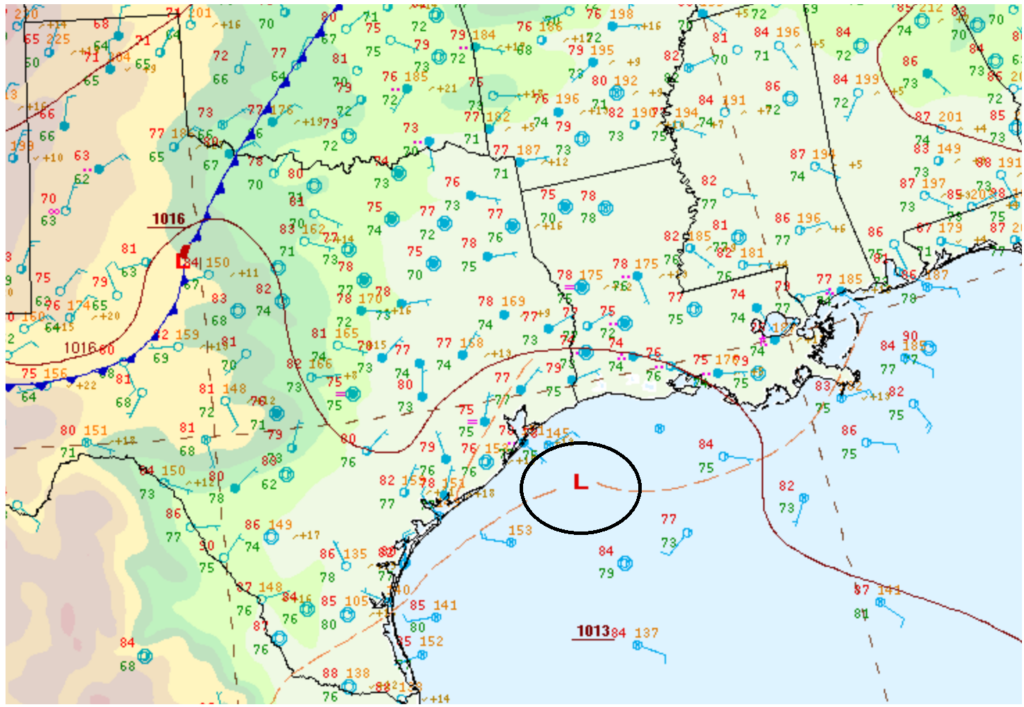
The surface low is rather broad, so it’s not as if we have a rapidly intensifying tropical system off the coast. But we have low pressure in the Gulf, which is always something of note. Any development risk from this is very low-end in terms of winds and waves. But in terms of rain, this will be a source for some serious coastal rainfall in the coming days, development or no development. Rain totals through next week may tally up an additional 5 to 10 inches between Galveston and Vermilion Bay in Louisiana.
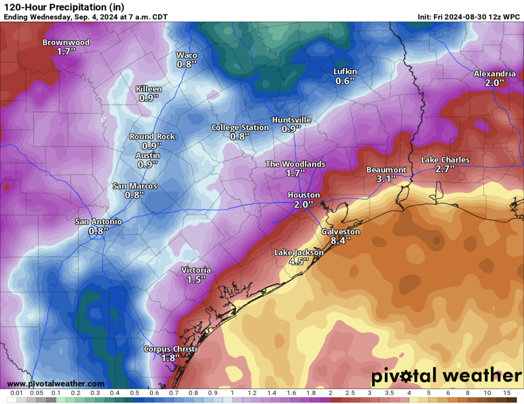
While there are no flood watches posted currently (except in the New Orleans and Baton Rouge areas), there is some potential for flooding to occur in coastal counties and parishes. Places like Galveston, Port Arthur, and Cameron through Morgan City and New Orleans could definitely see at least localized street flooding crop up. With a surface low now offshore, most of the rain will likely consolidate around that feature, meaning that inland places like Houston and perhaps Lake Charles see less rain, less often.
This will be a very coastal-focused feature. The low should meander in the days ahead offshore. Thankfully, upper level conditions aren’t super conducive for development, so again any organization or strengthening would probably be very sluggish and the ceiling from this is rather low it seems. As the system meanders, it could end up onshore in Louisiana or back toward the middle Texas coast, so proximity to land will also act against its development.
Bottom line: This is not a major concern, but it bears some watching and it will, at the least, deliver locally heavy rain and flash flooding potential on the Texas and Louisiana coasts.

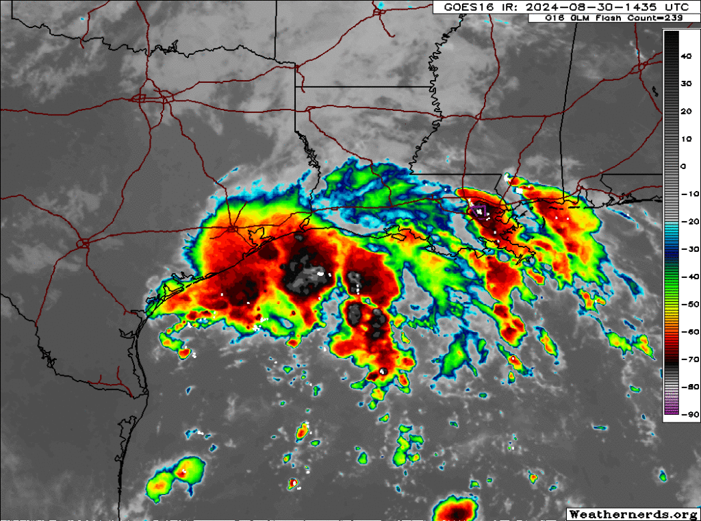
I could’ve sworn I saw tropical storm like rotating on the radar today. Thought I was going crazy with no one talking about it lol.
Hi @ObsessedWstorms …
You saw the rotation… early this AM on Fox26 Weather (TV), Mike pointed it out, as he’s done for a day or two now.
As I check now, it appears the swirling has moved over to Louisiana coast, so seems less of a bother for us TX folks (at least, for us up Magnolia way).
I don’t have cable so that would explain it lol
No cable here … all antenna TV
…I saw the same thing and figured we would hear something…and by golly SCW comes through!
i’m sorry if it was in the post, but what’s the time line for this?
the next 5 days or so
I was looking at upper level winds at 5K feet on the Windy app this morning around 5 before I left for work and I saw the counter-clockwise rotation centered right over my location. I said, “Hmm, I wonder what that’s all about?” Now, I know.