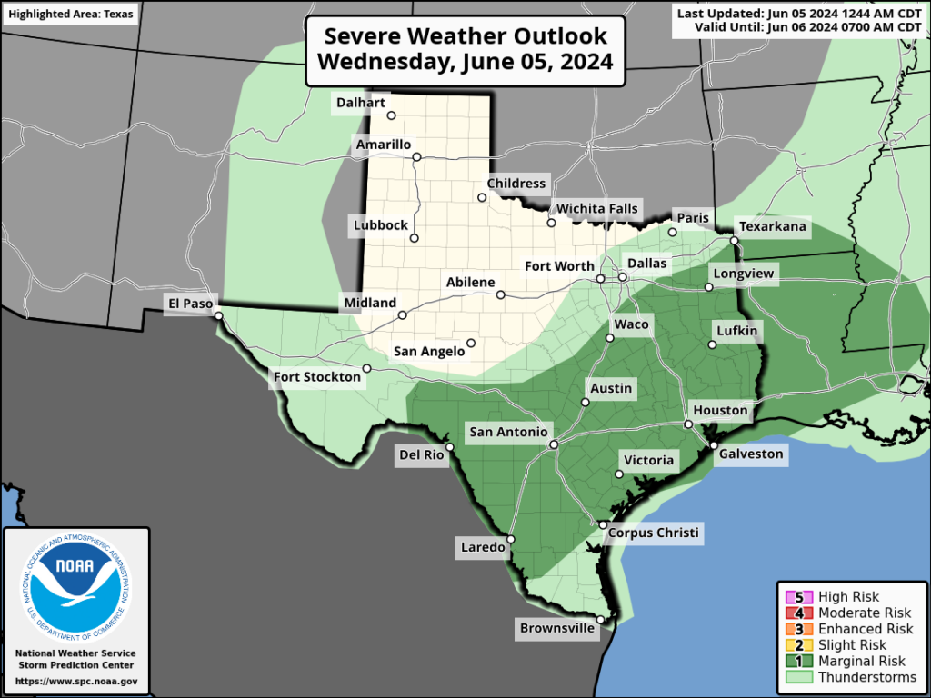
In brief: We may see a broken line of showers and thunderstorms move into the Houston region today, although I think rainfall accumulations will be hit or miss. Still, it’s something to be aware of if you’re going to be out and about today. After that we’re looking at several days of hot and sunny weather, although there’s a non-zero chance of a weak front early next week.
Hurricane season outlook
As you probably know, a majority of predictions have forecast the 2024 hurricane season to be especially active. On Thursday I’ll be discussing the seasonal outlook with Reliant’s Lyris Leos, and what Houstonians should consider heading into the season. The broadcast will occur at 2 pm CT on Facebook Live, and will also be available as a recording afterward. You can ask questions in the comments below, or on Facebook.
Wednesday
There is a complex of thunderstorms near Waco and Lufkin this morning that will move steadily southward. Although I’m not convinced this line of organized storms will hold together, some showers and thunderstorms may move into Houston later this morning, likely reaching areas such as The Woodlands and Kingwood 10 am to noon, central Houston an hour or two later, and pushing into coastal counties around noon or shortly after. Anything that develops will likely have cleared the area by this evening’s commute.
Rainfall amounts will be widely variable, with a few isolated locations perhaps seeing 1 to 2 inches of rain, and many other parts of the metro area no accumulations at all. I can’t rule out some severe thunderstorms with this line, but overall the chances for strong winds and hail are fairly low. Highs will depend on the extent of clearing this afternoon, but most locations should reach the low 90s with partly sunny skies after the system passes through.
Thursday
A sunny and hot day, with highs in the mid-90s across much of Houston. Rain chances look to be close to zero. Winds will be light, from the south.
Friday
Another hot and sunny day, likely the warmest of the week. Expect parts of Houston to reach the upper-90s.
Saturday and Sunday
The weekend should see continued hot and sunny weather, with highs in the mid-90s and plenty of humidity. Rain chances are low to non-existent. Lows will be in the upper 70s.
Next week
The forecast turns more interesting early next week. I’m not ready to make any guarantees, but there is an increasing likelihood that some sort of weak front may work its way into Houston. Since we’ll be well into June at that point, we still should be somewhat skeptical, but there’s a decent chance we’ll see some showers on Monday or early Tuesday, followed by an influx of some somewhat drier air. We should have more confidence in this forecast by tomorrow or Friday.

If we have a hurricane this year, what can be done if you have a handicapped person who is bedridden and who can’t be without AIR conditioning and the electricity goes out?
Have you registered with the power company that you have this situation? When my dad was bedridden and on oxygen, my parents did that and if they did happen to lose power, they were on a high priority list to have power restored quickly.
you can also go to the State of Texas Emergency Assistance Registry https://www.tdem.texas.gov/response/state-of-texas-emergency-assistance-registry. It will help local officials with planning and resource needs.
A few options, you can get some kind of generator, or you can go out of town. A neighbor here had to run an extension from his generator to another neighbor who has a dialysis machine.
Register this person with STEAR (State of Texas Emergency Assistance Registry, online or by calling 211). After a power loss event, RideMETRO and 311 can coordinate transport to a cooling center (at least if they’re in Houston proper). For people with extra special needs (oxygen, bariatric, etc), they can call 911 for transport to a hospital.
Consider a while home generator.
Every year I hear that more hurricanes than usual are predicted.
Huh, just last year the NHC forecast was best odds for a “near-normal” year. By contradiction, your claim is disproven.
Bring on the cloudy skies. No need to rain but the clouds can block the sun for a bit.
And, crossing my fingers for next week’s weak front to make it here. Every day is a day closer to the end of summer.
Models are pretty bullish right now, and I wouldn’t call it weak for June – mid 60 lows to mid 80 highs is a summer miracle for H(heat)Town.
Only Ch13 have gone out on the limb so far forecasting 60’s for lows and 80s for highs. I know its possible as it has happened here before. Hopefully it does come thru.
Skies are dark and it’s raining hard at i45 and 242 Conroe/The Woodlands. Hoping it will cool the air a bit.
Radar not looking very isolated right now, more of a green yellow blob.
I’m tired of rain.
There’s a huge blob of storms heading south right now about to hit northwest Harris County. Last night at midnight, National Weather Service said 30% chance of rain at around 4 to 5PM for today. Another totally blown forecast.
By the way…do you what a completely useless part of the National Weather Service forecast is, as the rain pounds my house right now? This, which is the CURRENT NWS forecast for my area “New rainfall amounts between a tenth and quarter of an inch, except higher amounts possible in thunderstorms.”
I don’t think my driveway ever gonna be dry.
Well … at least I still don’t have to water my plants? (just, you know, scrub the algae off the porch)
I acknowledge the irony of my complaining, given last year’s drought
Could we consider having live events on more than facebook….I know 1st world problems. I would love to catch this live but gave up on the book years ago. Thanks for your excellent coverage!
Read SCW, “broken line” and “not sure if it will hold together.”
7am radar image, wall of rain from Conroe to Dallas.
Hmmm…
I’m glad I’m not a meteorologist. Things are just getting too weird to forecast, seems like. Are the models just so out of whack these days or is something else happening that’s causing these things to defy what seems to be a logical deduction based on the data you have?
It is broken, we only got 0.13 inches with the main line.
But now its really coming down!
I also follow Texas Weather Center on YouTube, and one thing that he’s regularly been saying over about the past 6 weeks is that the models/computers have not handled any forecast in regard to rain very well. So, even with all of the modeling, data, and other things, it’s not going to be 100%.
It does seem that way lately.
It’s cynical, but opening a gambling book on weather (pun intended) or not we get hit by a hurricane this year ain’t a bad way to make some money. All signs are pointing in that direction anyway…
We in Santa Fe, Dickinson area are getting the “hit” part already although radar shows heavier stuff around 2p.
Fingers crossed for that cool front next week. Nights in the low 70s and upper 60s sounds like paradise at this point. I am already so over these overnight lows in the 80s with dewpoints in the 80s. My A/C vents have been dripping water on to the floor since late May. They started doing that last Summer. They used to never condensate and drip like that but these past 2 summers the dew points have been so oppressive for much longer periods than ever before. I’ve noticed that once dew points hit the upper 70s for an extended amount of time they start dripping. It’s not uncommon for dew points to reach the upper 70s and low 80s briefly during the summer months especially here along the coast, but it is not normal for dew points to be that high for weeks and weeks at a time with no let up.
Eric, just curious, can you explain the unusual banded nature of the thunderstorms that moved through the Houston area this morning?
Absolutely, except it’s “thank you God.”
Pretty sure rain is pretty agnostic.
lol, yeah
Just had a line of storms bring powerful wind gust in Sweeny. A big tree branch fell in my backyard. The Angleton airport reported a windgust of 48 mph. Other than the danger of falling trees it feels so much better outside now. It is 69 rain cooled degrees in Sweeny now. What a relief!
I think when forecasting a group of storms moving in from the north I would take into consideration the past few weeks. For whatever reason these storms are over performing.
Yeah, they definitely are. Turned up a few notches.
We are halfway between Tomball and Magnolia… at 8:30 am, the rain started … and it lasted until about 1pm.
It’s been raining pretty consistently for more than a month now. Yet, we keep hearing pattern shift, pattern shift, pattern shift from many sources reporting on the weather. After two or three days of dry weather, we seem to be right back to the storms. I’m just wondering if this is a mistake in the forecasting or if the term pattern shift is fooling me into thinking the dryer weather is going to last longer than it actually does.
True. But this is pretty normal June weather. Maybe its that we have been used to the last two summers’ extremely long dry periods which is making us assume that the heat domes will stick over us for weeks on end.
But also the models are just not working lately for some reason
What date did SCW discuss “derecho” wind storm? Had good explanation but cannot find it now. A search button on website would be helpful.
Thanks guys for great weather reports