In brief: Houston faces the potential for a few thunderstorms as a cold front rolls through the area this afternoon. Once it moves offshore we’ll see several splendid, sunny days through the weekend. Next week looks warmer, and decidedly spring-like.
Thursday
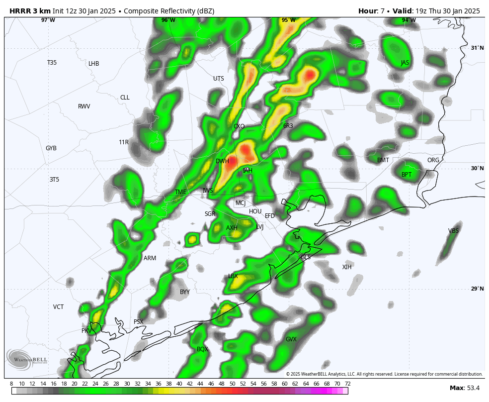
A line of showers and thunderstorms associated with a cold front is near Austin and Waco this morning, and it will move steadily southeast toward Houston today. It is likely to reach areas west (Katy) and north of Houston (The Woodlands) by or before noon, and push off the coast by around 4 or 5 pm CT. For most of us, I expect these to be briefly passing showers, but some areas may see thunderstorms and damaging winds. Ahead of the front expect temperatures in the lower 70s, dropping 10 degrees after its passage. Lows tonight will fall to around 50 degrees in Houston.
Friday
Sunshine returns on Friday, with much drier air. We’ll see gusty winds from the north, perhaps reaching about 20 mph, during the daytime. Highs will likely rise to near 70 degrees. As winds die down we’ll see our coldest night on Friday night, as temperatures dip into the 40s by Saturday morning.
Saturday
This will be a fine day for just about anything. Expect low humidity and high temperatures of about 70 degrees. Skies will be clear and sunny, with light winds. Lows on Saturday night will fall to around 50 degrees in Houston, with cooler conditions further inland.

Sunday
As the flow turns more southerly, conditions on Sunday will be a tad warmer, with highs perhaps reaching the mid-70s. Skies will remain sunny, however. Lows on Sunday night will only drop to around 60 degrees in Houston.
Next week
This will be the warmest week of 2025 so far, and feel much more spring-like than winter-like. Expect highs in the mid-70s to 80 degrees, with a mix of sunshine and clouds. With dewpoints in the 60s it will feel modestly, but not oppressively humid. Nighttime lows will be in the 60s. There probably will be some scattered showers on some of the days, but I don’t see a huge signal for any rain showers. It does look like some sort of front arrives by next Saturday or Sunday to cool us down, and remind us that it’s still February. My guess is that it knocks lows back into the 40s, but we’ll just have to wait and see.

I could use a couple rainless weeks to dry up. My backyard is a pond.
A pond is my backyard.
A week would be nice, maybe 10 days. Either been sicl, loaded down with work, or raining since I dug out a hole in my back yard for a patio. Now it’s constantly a pond or thick mud from rain.
Slimely mudhole – my home this is
So winter is over now. Got it.
I dont know about anyone else, but I’m sick of being wet.
It seems like it’s been trends of boom or bust quite a bit lately.
A cold front (minus the rain) for the Galveston marathon/half marathon would be much appreciated – please and thank you!
Ugh. Looks like our 11 month summer is returning. Sigh.
Unfortunately yes. The almost one month of winter we just had flew by far to quickly. It was nice not feeling sticky and sweaty just walking to my truck. Don’t worry next January is coming