In brief: In today’s post we dive into the timing for a second round of precipitation tonight, and when and where that is likely to transition over to freezing rain and sleet. Additionally, cloud cover is complicating the forecast for lows on Monday morning.
Precipitation overview
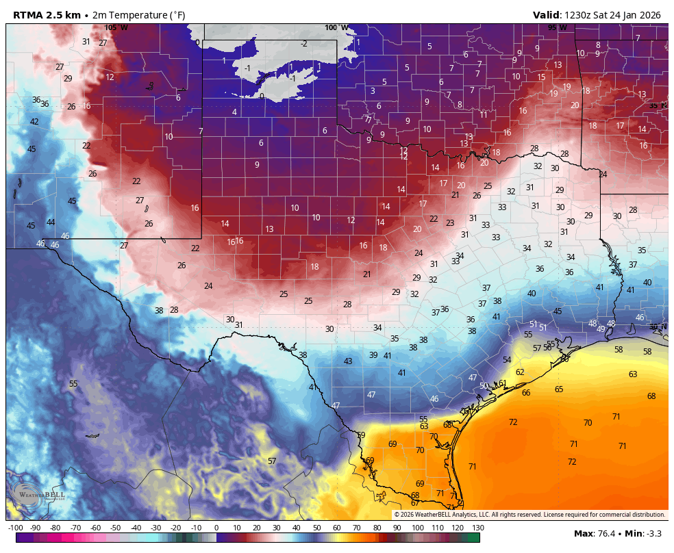
As of 6:30 am CT on Saturday we are seeing widespread showers, and a few thunderstorms, moving through the region. This was entirely expected, and will drop between 0.5 and 2 inches of rain for most locations. These rains are actually rather beneficial given our region’s ongoing drought, and since temperatures today will remain above freeze there is no threat of ice from them. The main mass of these showers should exit the region to the east by around 9 am, with a few lingering showers possible later this morning and into the afternoon.
Then, later this evening, another round of showers will move in from the west, and persist sporadically overnight into Sunday morning. These will exit to the east by mid-morning on Sunday. This second round of precipitation could drop 0.5 to 1.0 inch of water. Now, the question is if and when this rain on Saturday night and Sunday morning transitions over to freezing rain.
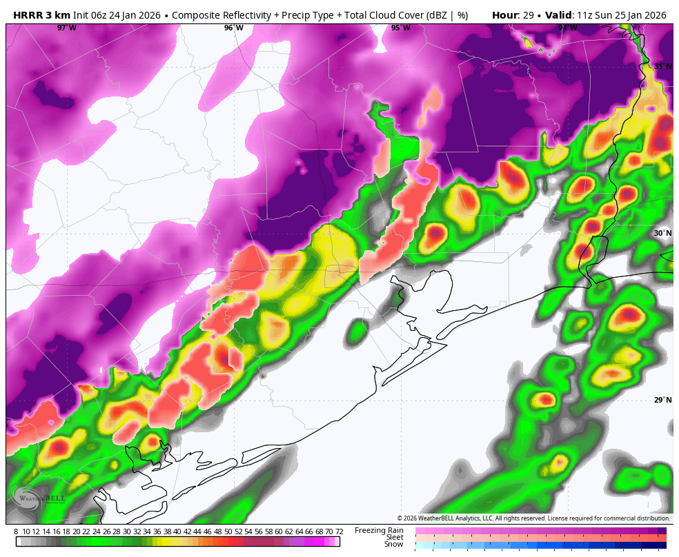
For areas along and north of Highway 105, which includes places such as College Station, Navasota, Conroe, and other locations, this transition could occur as early as 7 pm and 10 pm on Saturday evening. A little closer to the Houston metro area, for places such as Katy and The Woodlands, this transition (should it occur) will happen a little later, perhaps between 10 pm Saturday and 2 am on Sunday. Then, after midnight, we are likely to see a mix of rain, freezing rain, and possibly sleet in central areas such as Sugar Land, urban Houston, Kingwood, and so on; basically areas along and inland of Highway 59/Interstate 69. For areas closer to the coast is is possible this line of freezing rain/sleet transition continues, or it may remain just warm enough to preclude the formation of freezing precipitation.
In any case, when you wake up on Sunday morning, you will want to pay very close attention to road surfaces. For central and northern Houston there is a reasonable likelihood of a light sheen of ice, which will make driving hazardous.
Sunday
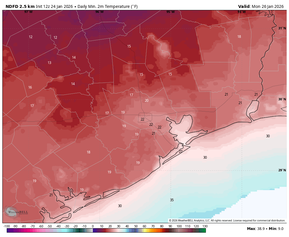
Most of the area will start out on Sunday with temperatures around freezing, perhaps a degree or two below or above. One important question is whether air temperatures rise much. I’m starting to think the answer is probably not, because skies are now likely to remain mostly cloudy during the daytime. It is therefore possible that any ice that has accumulated on roads (which again, is likely to have occurred in many locations along and north of Highway 59, and possibly further south) will stick throughout the day. However if temperatures do rise above freezing some of this ice may melt, especially with the aid of northerly winds to dry roads. Speaking of those winds, they will represent the full surge of Arctic air moving in, likely gusting up to 25 or 30 mph on Sunday afternoon. This means it will be very cold outside, even during the daytime. Temperatures on Sunday night will be tricky, because if clouds linger it will provide some limited “insulation.” Accordingly I think low temperatures in Houston will likely fall into the 20 to 25 degrees range, with upper teens to lower 20s possible to the west (Katy and beyond) and north (Spring and Kingwood) and beyond.
Monday
Ok, so will there be ice on the roads on Monday? Will the airports be effectively shut down? Will you have to go to work or school? This is the question everyone wants answered, and I don’t have anything definitive for you (except for some schools that have already shut down). I think, for at least parts of the Houston metro area, there will be ice issues on roads. It may be regional. For example, Bush Intercontinental Airport might be iced in (such that workers cannot get there) whereas Hobby Airport has more passable roads. But honestly, we could see any scenario from very limited ice impacts (excepting elevated roads and bridges) across Houston to pretty widespread impacts on Monday morning. We probably won’t have a definitive answer on this until Sunday, when we see how much ice has accumulated, and what temperatures that afternoon do. I know, I know, that’s not particularly helpful.
We do expect the return of sunshine on Monday, which is great because it should allow afternoon temperatures to rise into the 35 to 40 degree range, helping to clear roads in most locations, hopefully even our far northern areas along Highway 105. We’ll see about that. The downside of the clearing skies is that they will bring another very cold night into the city, with temperatures likely on par with Sunday night. So a hard freeze for many, if not most locations.
The rest of next week

Tuesday, Wednesday, and Thursday of next week should be comfortably in the upper 40s and then early 50s for daytime temperatures. We still might see some light freezes, but nothing too concerning after this weekend’s mess. We should see a decent amount of sunshine. There is the potential for another Arctic front next weekend, but at this time I’m not sure Houston will see a direct shot of the coldest air. So I’m hopeful that we won’t see temperatures drop significantly below freezing. However, we’re not ruling anything out, including the possibility of a wintry mix remix. For now there’s way too many unknowns to say anything intelligent about such a forecast, however.
Saturday Q&A
I’m going to do another Q&A with readers on Facebook at 11 am CT today, so bring your most difficult weather questions and I’ll do my best to answer them. We will once again share the most commonly asked questions here, along with the answers, in a follow-up post.
Our next full update after this will be published around 3 pm this afternoon.
