Sizzling heat (with a bit of dry air) for a bit longer before rain chances increase this weekend

In brief: Houston will see one more very hot and sunny day before rain chances return to the forecast. The best odds for rain come this weekend, but even then we don’t anticipate a total washout. Highs remain in the 90s throughout the forecast period, as is typical for this time of year.

Overall pattern

High pressure will hold sway for another day or two before giving way to increasing moisture levels from the Gulf. With the ridge breaking down, the Houston region will be more open to showers this weekend, although we don’t anticipate anything too calamitous. As we get later into August next week, a fairly typical pattern will set in whereby high pressure influences our weather, but there is still the possibility for some afternoon showers and thunderstorms due to the sea breeze.

HRRR model forecast for dewpoints at 3 pm CT on Wednesday. (Weather Bell)

Wednesday

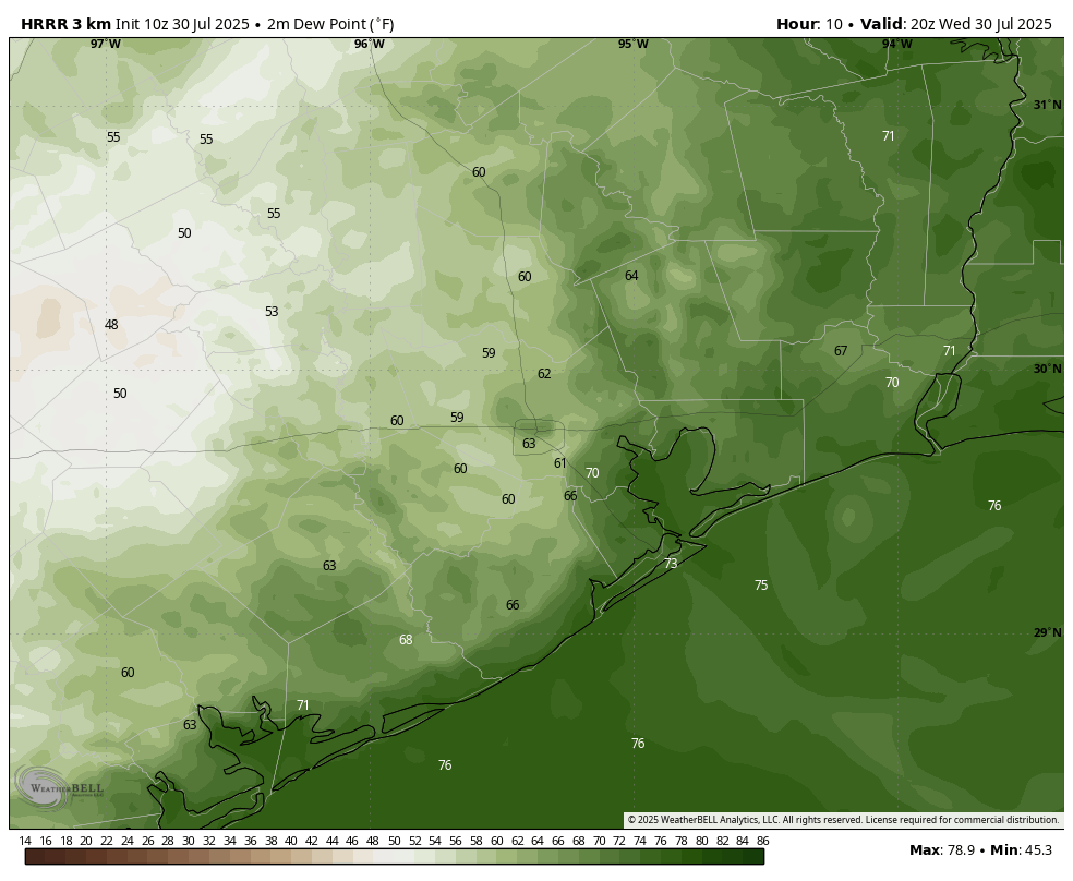
The high temperature at Bush Intercontinental Airport hit 99 degrees on Tuesday, and we are likely to do the same today, and possibly push into triple digits across some parts of the area. A surge in air temperatures today will be supported by the influx of somewhat drier air from the west. It’s not clear how far this drier air will push into Houston, but we could see some rare dewpoints in the upper 50s today along and west of Interstate 45. It’s still going to be quite hot, but for areas away from the coast it should feel a little less humid. Skies will be sunny, with light westerly winds. Lows tonight will drop to around 80 degrees.

Thursday and Friday

The last two days of the work week will see more moisture streaming in from the Gulf, and this will start to elevate rain chances a bit, perhaps to 30 percent each day. Don’t get me wrong, these will be mostly sunny days, and any showers that develop will likely pass quickly. But the increased moisture should help to limit high temperatures to the upper 90s for most of the region.

Saturday and Sunday

The weekend will bring the highest chance of rain, likely around 50 percent for both days. The odds and accumulations of rain are likely to be higher the closer to the coast you are. For most of us, I expect rain totals in the 0.25 to 0.5 inch range. However, given the tropical nature of this rainfall we cannot rule out some stronger, isolated downpours that briefly flood low-lying streets. Both of these days should still bring partly sunny skies. Highs will depend on the extent of rain and cloud cover during the afternoon hours, but probably will be in the vicinity of the mid-90s with plenty of humidity.

Temperatures next week look warm in Houston, but the greater heat should be anchored over West Texas. (Pivotal Weather)

Next week

The first full week of August will likely bring mostly sunny skies and highs in the mid- to upper-90s. Expect some isolated to scattered shower chances daily, but at this point it’s difficult to say more than this. Basically, August will do August things. Which in Houston means pain.

21 thoughts on “Sizzling heat (with a bit of dry air) for a bit longer before rain chances increase this weekend”

  1. I’m VERY excited for today and Thursday. We rarely get to see humidity this low.

    I plan to go outside, exercise, and feel the sweat evaporate from my body.

    Reply
  2. Got an email from Reliant yesterday, with the opening statement:
    As a participant in Reliant’s Degrees of Difference program, you could earn $0.60 per kWh by reducing your electricity usage tomorrow (Wed) from 6:00 pm to 9:00 pm.

    That means, obviously, they are expecting high electrical demand. (or maybe ERCOT suggested this to all providers?). Anyway, that email is obvious evidence of these two high-heat days (for this year, anyway).

    It got to 98 here in Magnolia for a brief period, yesterday. Right now, it’s 72. The predicted high for today shows to be 98 (again) for our area. Will be nice if we get the anticipated rains!

    Reply
    • ERCOT’s supply/demand curves come very close to each other right around 8 PM tonight, as the solar drops offline and demand remains high. We should have approx 10k MW buffer through today, though.

      Reply
  3. Noticed the change in dewpoint immediately this morning. Normally when I take the dogs out upon waking, I have to avoid the patio furniture, else I end up with a soggy bottom… but today all the chairs were nice and dry.

    Reply
  4. I know you cater to the audience, but, making a big deal of reaching the round figure of 100 in a temperature scale that rest of the world does not even recognize is laughable. Reminds me of the SNL skit where George Washington says that we will measure temperature in Fahrenheit, but nobody can spell it. How about 37.77777 Celsius? That is pretty neat number too!

    Reply
    • We like Fahrenheit, and if you don’t please don’t let us stop you from moving to where they don’t know how to spell it or pronounce it.

      Reply
      • Celsius is by far the dominate temperature standard on the globe. Just because many of us here in America grew up w the antiquated Fahrenheit measurement, doesn’t make it better.

        Maybe Eric & Matt can switch to Kelvin in their descriptions, & thinly veiled comments will disappear.

        Reply
    • Yes, how DARE Space City Weather, a site devoted to reporting on weather in Houston, Texas, reference the temperature scale used ::checks notes:: IN Houston.

      Reply
    • The US adopted the Fahrenheit scale because of its use in Britain when the colonies were established.

      Did you know the name is from the physicist who created the scale?? Yea, Daniel Fahrenheit, way back in 1700-something. Anyway, it was adopted in England back then, before America.

      Although the US has proposed switching to the Celsius system, it’s voluntary, because of the vast resistance to change to it.

      So, P Ravishankar … you can switch to use Celsius , because it’s voluntary. You could print out F <=> C conversion matrix chart when reading SCW 👍

      Reply
      • Not just ‘resistance’ to change but it’s nearly impossible now that we’ve industrialized and standardized. I can’t imagine trying to refit entire refineries to metric, much less all the pipes currently in the ground.

        Reply
    • Fahrenheit created the scale based on how temperatures feel to the human body. 0 F is what feels very cold (freezing point of ice water) and 100 F is what feels very hot (temperature of the human body, though Fahrenheit must have had a fever that day). It is a very logical and human base system of measurement. Does 37 C make so much more sense? 100 F is a very important milestone, because it is hotter than the human body. It’s not in any way an arbitrary number.

      Reply
      • Just a quibble but zero is the melting point of brine. 32F is pure water. Hotter than the body at 100 makes more sense than 37C! That’s why we like this scale here in the good old USA. It is exceptional to be different from the “billions” and engineers can easily switch back and forth – but BTUs beat joules every time. Fun topic.

        Reply
  5. I realized I might generate the comments that it did with my post. It was in jest. As an engineer, I have used both scales all my life. NP.

    Reply
    • When you wrote, “reaching the round figure of 100 in a temperature scale that rest of the world does not even recognize is laughable,” that sure didn’t come across as being “in jest.”

      Then again, maybe the rest of us just don’t get engineer humor.

      Reply
    • Well the temperature in the comments section sure changed. May be best not to inflame people on a sizzlin’ hot day

      Reply

Leave a Reply. URLs require moderation.