Slightly less hot weather and a more active weekend of showers expected for Houston

In brief: Unsettled weather will return to Houston today through Sunday or Monday. Isolated heavy downpours are possible in spots, along with some locally stronger thunderstorms, especially Saturday and Sunday. A return to strong heat is looking likely later next week.

Welcome to August, widely considered the worst month of the year in Houston. I, Matt, disagree because I think September is worse, psychologically at least. Whatever the case, this August will start hot but not ridiculously so as thunderstorm chances re-enter the picture. By next week, we may be back on August blast furnace watch again. Another scorcher.

Today

We’re starting off today with a couple showers and downpours up in Liberty County that are drifting southward. I’d suspect those continue toward Trinity and Galveston Bays, so if you live on the east side, don’t be shocked to see some raindrops this morning.

Elsewhere, it’s quiet, but we should see showers and storms perk up in spots this afternoon with daytime heating. Many, if not most of us will stay dry today but those that see showers and storms could see some pretty hefty rainfall on the order of 1 to 2 inches in a short period of time. Otherwise, look for highs in the mid to locally upper-90s, not far off normal for this time of year.

Saturday

Coverage of showers and thunderstorms should pick up tomorrow. The combination of a dying cold front to our north and lots of moisture in place should allow downpours to blossom with daytime heating. Locally heavy rain is possible. The pattern of storms won’t be typical for this time of year, as we’ll see most of them form north of Houston and drop southward, unlike typical summertime sea breeze storms which come from the Gulf and work inland.

A marginal risk (1/4) for flooding and excessive rain is in place both today and tomorrow (shown) for Houston. (NOAA WPC)

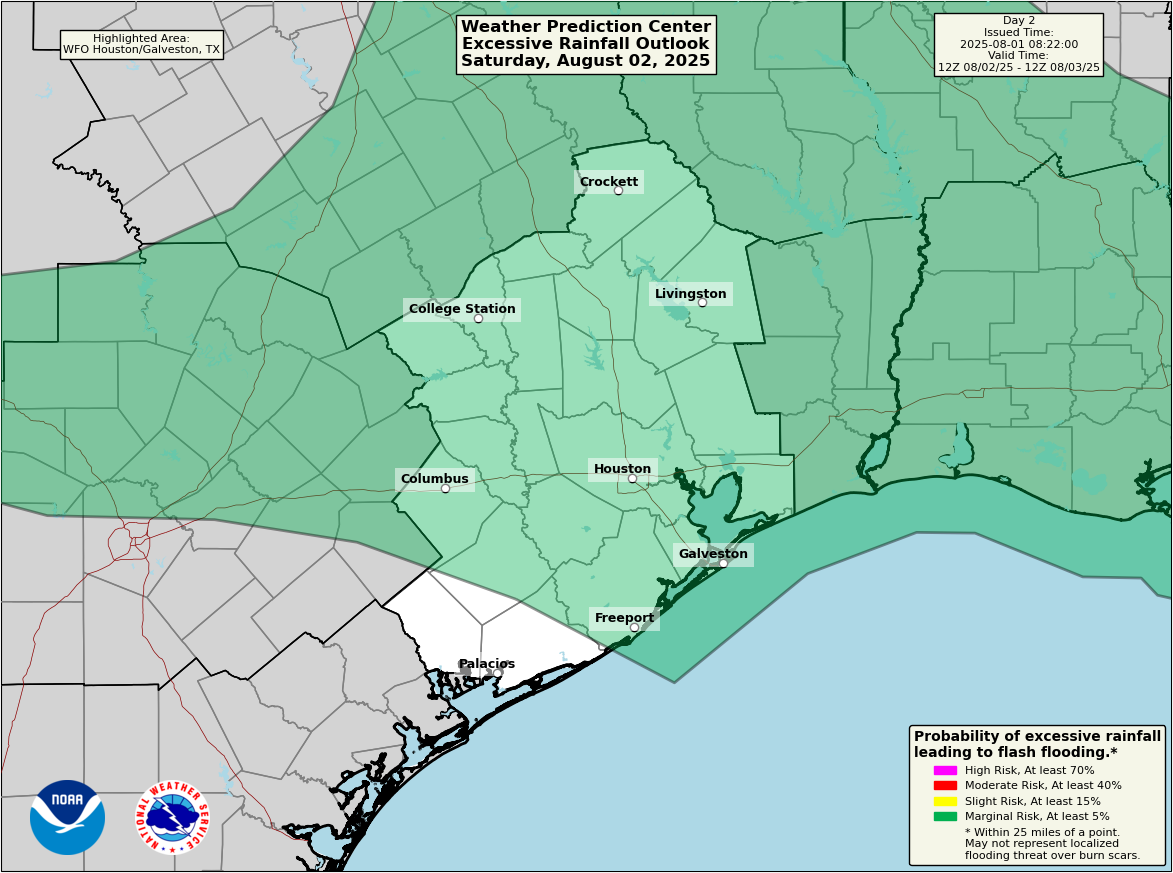
While we aren’t currently expecting severe weather, I’ve learned over the years to be cautious of north to south moving storms in spring and summer. I wouldn’t be shocked to see an isolated case of a storm misbehaving for a short time. Just something to be aware of. Clouds and showers should hold temperatures back some tomorrow, so look for generally mid-90s and possibly a bit less hot than that in spots.

Sunday & Monday

With high pressure anchored over the Southwest and a disturbance tracking across the Plains and Texas Sunday into Monday, we should continue to see scattered storms in the area, some of which may form in interior Texas and drop southward, more like late spring than late summer. Continued unsettled conditions will prevail to close the weekend and start next week.

Total rainfall through early next week should average around an inch or less in most spots. There will be isolated smaller “lollipops” of 1 to 3 inches. (Pivotal Weather)

High temperatures will likely be in the low to mid-90s.

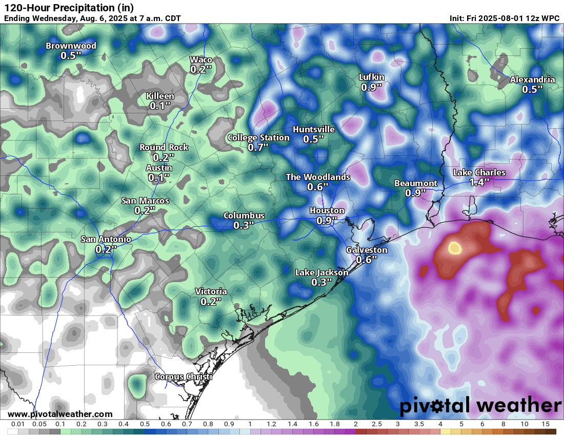
Once all is said and done with the storms through Monday or Tuesday, expect 1 inch or less in most spots, however some more isolated, localized places could easily see up to 2 or 3 inches in locally heavier downpours.

Rest of next week

High pressure over the Southwest is going to flex its muscles beginning Tuesday or Wednesday, and it’s likely that we see some solid heat return to the area for a time later next week.

Strong odds of hotter than normal weather for days 6 to 10. (NOAA CPC)

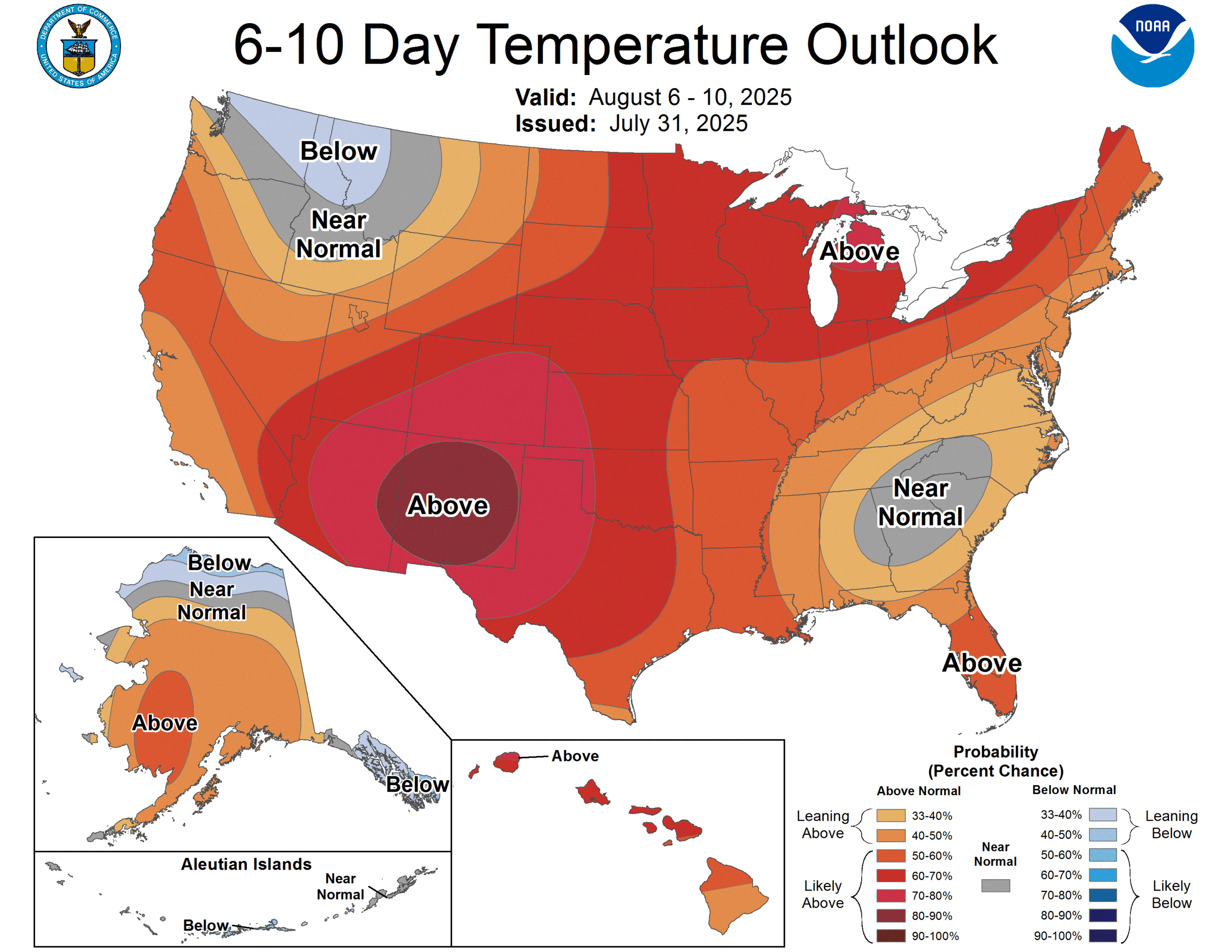
Our next swing at 100 degrees will probably occur next Thursday or Friday. We shall see.

16 thoughts on “Slightly less hot weather and a more active weekend of showers expected for Houston”

  1. “I’ll call today!”

    “YOU’LL CALL NOW.”

    “….I’ll call now.”

    hah, wow, I remember seeing that commercial about sixteen trillion times 😀

    Reply
  2. “August was smoking hot, then September walked in as cool as a cucumber, and made her presence felt.”― Charmaine J Forde

    Matt, September never comes in that nice in Houston, TX. but statistically the ninth month is almost 5 degrees cooler than August. So I would agree with Eric that August is the worst month in Houston. Personally I would place both July and June above September on the “misery” scale.

    Reply
    • The thing I hate about September is you’re just dying for some Cool weather after August. But no dice, September is just as hot.

      Reply
      • That is 100% how I felt about October last year!! I was using my AC until freggin Nov 10 last year on a daily basis and I set my AC to high 70s usually. That’s how hot last fall was. Just give me a normal October and November and I won’t complain about September being hot!! 🙏 🙏 🙏. Nothing is more painful than a summer that lasts an extra 6 weeks!! I still feel the trauma from last summall (summer in fall)

        Reply
    • September hits especially hard for those of us that have lived somewhere where September means actual fall weather and everything that comes with it.

      Reply
      • Down here the end of September usually feels much better than the beginning. For those of you that come from northern latitudes think of it as March but in reverse. “Comes in like a lion and out like a lamb”…

        Reply
      • I am a native to Southeast Texas and I still personally don’t consider us to be in true fall until either late October or mid November lol

        Reply
  3. I’d gladly take a September being almost like August if it meant October could be near average temps. Last October was just so painful with no rain, endless sun, and insanely warm temps. Even reaching an insane 99 in October 15. August in September is something I can accept but August in October is not!! Rooting for a normal fall this year and not a record breaking warm one like 2024!! Feels like all I can count on for fall is shorter days but not cooler temps or rain in recent years. Also is it just me or does October’s 6 inches of average rainfall seem insanely unrealistic?? I’ve never seen a wet October since I moved here 5 years ago.

    Reply
    • The last really wet October we had was in 2018. We had a few super wet Octobers over the past 30 years which helped up the average some. Most Octobers are either dry or only a few inches of rain at best.

      Reply
  4. :Did anyone see a dust storm in Cypress off Fry Road and West Road at around 7:15pm this evening? It looked like a large beige dust cloud with lightning and rainbows.

    Reply

Leave a Reply. URLs require moderation.