In brief: After a very cold end to this week, Houston begins to warm up this weekend. It’s possible some of this weekend’s rain begins as mixed rain and sleet tonight and Saturday morning, but no accumulation will occur. A decent rain for parts of the area this weekend will lead to quieter, warmer weather and patchy fog next week.
Yesterday ended up being the fourth coldest day of winter on an average temperature basis, with the high and low combining to average about 35 degrees. Our coldest day this winter was back during our January snowstorm, with a daily average of 32.5 degrees. One of the challenges with “daily average” is that if you have a high temperature at midnight, as we did on Wednesday, it doesn’t necessarily capture how the true day was. Whatever the case, it has been a cold finish to the week.
Today
This morning? Not quite as cold.
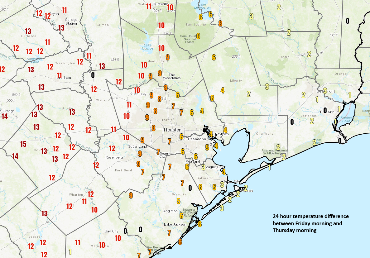
We were probably helped by some clouds that started to roll in after sunset. That said, it’s still chilly this morning, and with the cloud cover, temperatures will struggle again today. The forecast high is around 40 degrees, and there’s at least some chance we never get there and stay mired in the 30s all day. Bundle up.
Tonight: “Conversational” sleet?
Temperatures won’t go very far tonight; they’ll probably stay in the mid to upper-30s, rising a bit toward sunrise possibly. There is a chance of some light rain or drizzle both tonight and Saturday morning. With the cold, dry air mass still in place, I would not be at all surprised to see some of the precipitation fall as sleet in spots. It won’t accumulate, but this is the kind of setup that would periodically lead to you leaping out of your chair because you “thought you heard pinging outside.” And indeed, you’d look and see some ice pellets falling or a small gathering of them in your gutters. Whatever the case, conversational wintry precip is possible tonight and early on tomorrow, but again no real accumulation will occur.
Rest of Saturday and Sunday
As Saturday progresses, onshore flow continues, and temperatures warm we will see more and more scattered showers develop (no more sleet). A few heavier showers or even some non-severe thunderstorms are possible tomorrow afternoon, especially south and east of Houston. That continues into tomorrow night and Sunday before the whole thing shifts east of the area by midday Sunday, leading to some gradual clearing.
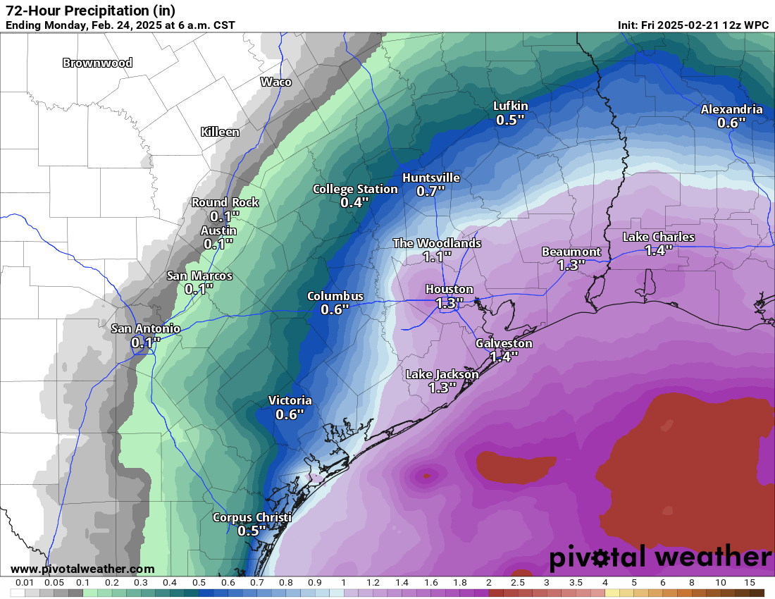
All told, this should be a good soaking for coastal areas in particular. As you go north and west of the city, rain totals will sharply drop off to under an inch and probably around or under than a half-inch from Conroe through Columbus. Sunday’s high temperatures will bounce back into the 50s.
Monday through Wednesday
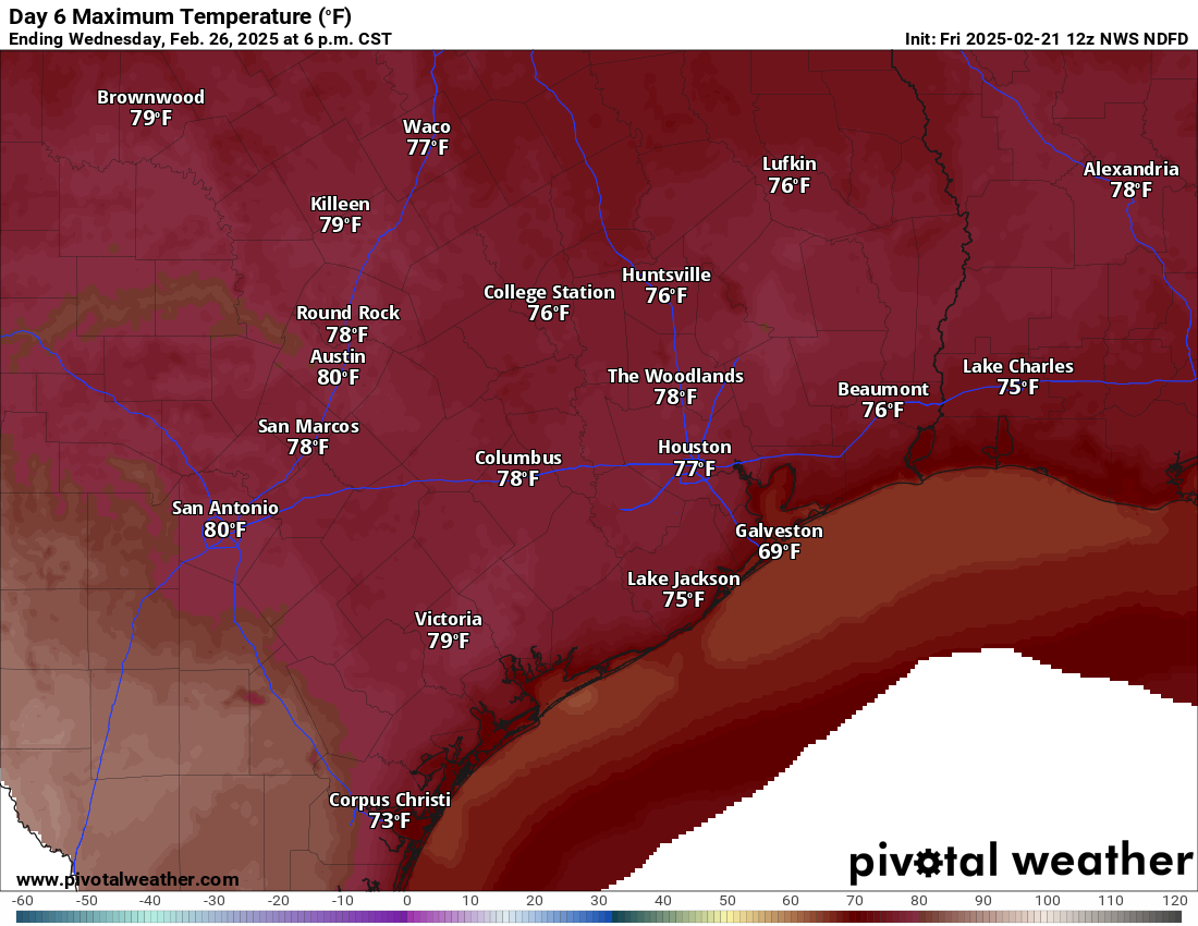
We are going to head back to spring next week, with a big warm up Monday (upper-60s to near 7), Tuesday (low to mid-70s), and Wednesday (mid to upper-70s). We should see sunshine return as well in this time. There will probably be some locally dense fog Monday morning, so just be aware of that. And with warm weather after a decent cool spell, you can almost guarantee that sea fog will return to coastal areas for at least a time next week.
Our next cold front looks to arrive sometime Thursday with just a slight cooldown for us. No sign of additional freezing temperatures is showing up in the forecast. But, as it goes, things can always change. We’ll continue to watch.

When is it maybe going to sleet?
They said tonight, but is that like 6 pm-ish or 9 or later?
Does anyone know?
Uncover plants today…..or maybe keep covered 1 more night?
Nope, I’m playing it safe and keeping the covers on until maybe Sunday.
Change of plan, I’ve just uncovered all the plants and pots. It will not freeze tonight so I’m letting the plants breathe.
I’m leaving the plants in the garage for one more night.
It seems that with computers today and constant temperature monitoring, we should be able to have better daily averages than averaging the high and low temperatures for each day. Why doesn’t the NWS do daily temp averages based on taking the temperature every hour or minute?
If you want hourly temps there are apps/ sites that try to provide that. avg temps reporting is to provide general overview of expected weather conditions and to use to compare with historical data
I’m running Surfside 1/2 marathon @ 730am. What can you predict? My 3rd 1/2, and first with rain/sleet possibilities 😖
I’m going to be taking pics for the 10k downtown… it’s going to be pretty rough. 40ish and humid and possibly light rain.
I am going to predict….. 2 hours 35 minutes.
We have an outdoor wedding ceremony planned on March 14. Does it look like we are trending to lovely spring weather by then??? I’m starting to get a bit worried.
Joseph usually answers these questions…has a wealth of previous weather stats to fine tune a confidence interval for you – and might just be entertained to do it. Too far out for a forecast. The next troposphere PV displacement everyone is talking about looks to be 1st half/week of March. All done by 14th. Good luck.
Lol your thoughts are about the same as mine. There is no telling what will actually happen that far out but historically speaking it will likely be mild or warm weather on March 14th or stormy. But the occasional cold snap can happen in mid March. In 2022 our last freeze of the season was actually on March 13th.
Interestingly enough our region actually experienced snow flurries on March 12th 1932. I would be willing to bet my 401K that doesn’t happen this year.
Haha. Hope LJ reads this. We worked hard on this Mar 14 prediction. Sunny, warm.
If it is your own wedding, best of luck – you are going to need it. It might work out if you don’t set your expectations too high.
“According to the American Psychological Association, approximately 40-50% of first marriages end in divorce. The divorce rate for second marriages is even higher, with approximately 60-67% of second marriages ending in divorce.”
What a kind gesture to point out that statistic, Ken. Here’s one for you in return: there’s a 100% chance that you’ll die.