In brief: This morning’s update discusses the tornado outbreak on Saturday, and looks ahead to milder weather this week. We also discuss the increasing potential for much colder weather beginning next Monday in the Houston region. But just how cold will it get?
Tornado recap
The National Weather Service has completed its preliminary analysis of six tornadoes in the greater Houston metro area on Saturday, December 28. These included an EF-3 tornado near Porter Heights and Splendora, which had a ground track about 10 miles long, and an EF-2 tornado in Brazoria County with a ground track of nearly 9 miles. This latter tornado killed one person and injured five people, and also did major damage to Walt Disney Elementary School in Alvin. Many teachers lost educational materials due to the tornado, and you can donate to support their efforts to recover here.
Houston experienced three days of violent weather in the last week, which is a rarity for this time of year. Fortunately conditions should settle down now. Our next big concern is the potential for a hard freeze about a week or 10 days from now, which I’ll discuss further below.

Monday
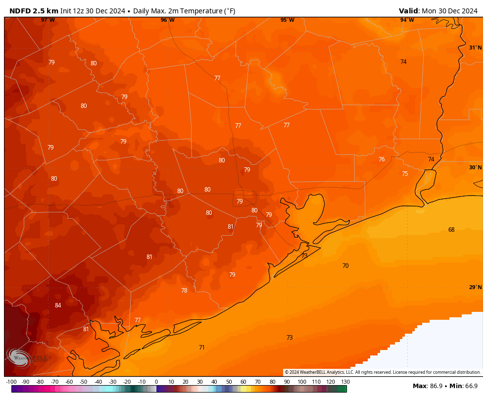
With air temperatures and dewpoints both in the upper 50s this morning, we are dealing with marine fog across parts of the metro area. This should dissipate later this morning as temperatures rise. It will be a warm day, with sunny skies and highs of around 80 degrees. Southwesterly winds will aid in the flow of warmer air into the area. Lows tonight will generally be in the 60s through the evening hours before a cold front (likely without precipitation) pushes down into the area after midnight.
Tuesday
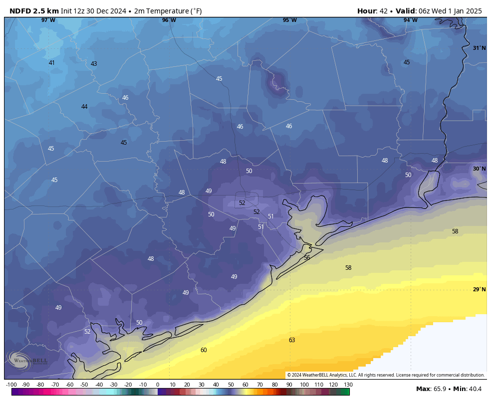
We should awake to cooler conditions, in the 50s, on Tuesday morning. Highs will likely peak in the mid- to upper-60s for most areas with sunny skies and drier air. If you’re going to be out and about on New Year’s Eve, expect cool temperatures in the lower 50s, with a northwest breeze. Besides the cooler conditions, there should be no other concerns for New Year’s Eve. Lows on Tuesday night will drop into the mid-40s.

New Year’s Day
We will start the new year cold and clear, with highs likely only reaching the lower 60s. Expect to see sunny skies.
Thursday, Friday, Saturday, and Sunday
The second half of the weekend will bring a gradual warmup into the area, with partly sunny skies and highs in the upper 60s to lower 70s. As atmospheric moisture levels rise we’ll see some low-end rain chances each day, but accumulations at this point do not look overly impressive. By Sunday or Sunday night the next cold front should push into the area, potentially setting the stage for a significantly colder period.
Potential for a hard freeze
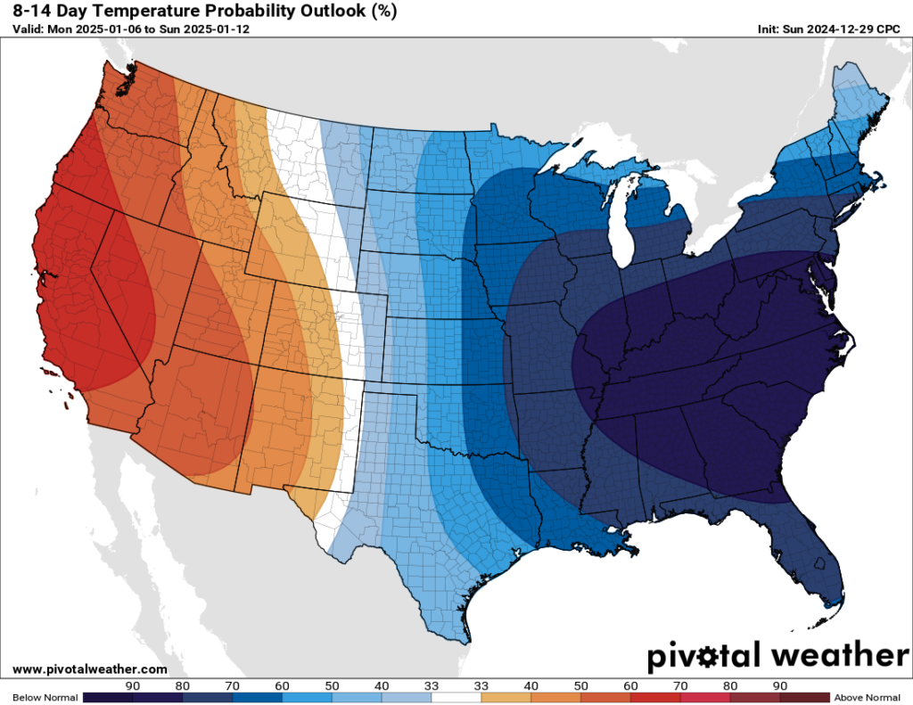
Since Matt addressed the possibility of a hard freeze on Friday, we have continued to gather more data, and the story has changed somewhat. The bottom line is that we could see our first Arctic air of the season next week, although the details of just how cold things get are still fuzzy.
For Texas, it’s the usual story in winter. A significant slug of colder air is going to drop down into the eastern United States from Canada. This differs from the more zonal flow we have seen this winter to date, in which modified colder air comes down from the Pacific Northwest, rather than the really cold stuff directly down from northern Canada. The question for Texas is whether this Arctic air dives down into the state, or gets shunted off to the southeast. This time I think we’re going to get plenty of colder air next week, but we are unlikely to see the worst of it.

With all of that said, my sense is that an initial surge of colder air next Monday will drop area-wide lows into the 30s for much of the Houston region (the coast may be warmer, and the usual suspects for inland areas may see a light freeze). Then, with one or two additional pushes of colder air, temperatures are just going to get colder through the week. Since we’re talking about a period 10 days from now it’s impossible to say how cold, but at this point I don’t think we can rule out lows in the 20s by Friday or Saturday of next week. Whether that’s lower 20s or upper 20s, we just cannot say. If we get some precipitation there is a low-end chance of some snow or a wintry mix toward the end of next week, but the odds of this happening are probably on the order of 10 percent at this point.
Anyway, this is something we’ll be watching all week, and we’ll keep you informed as we go along.

Houston gets tornado warnings on a regular basis; why don’t we have tornado sirens like other parts of the country?
We don’t get tornados on a regular basis because we are so humid and tornados usually are a clash between dry air environments and Gulf moisture sucked in.
Sirens wouldn’t work because of the size of the county and the sporadic nature of them here.
But if it really was a “clash between cold dry air and warm moist air”, then every single cold front would be having tornadoes.
So, I think that “clashing” is more responsible for the general extratropical cyclone/storm formations. Whereas the tornadoes (which mostly occur in the warm sector, where humid throughout) likely arise from some other factors (esp wind shear, or any change in wind direction with height).
I think a strong cap also tends to be instrumental (but that seems more for spring rather than winter).
We don’t get tornadoes often here because the jet stream winds don’t settle directly over SE Texas very often. The upper level jet stream winds are what causes the wind shear needed to create tornadic storms. Even when the jet stream winds do settle over our region, it’s usually after a cold dry airmass has moved through which kills the instability at the surface. Often times we also have a strong cap or Temperatures inversion that prevents severe storms from being able to fire up ahead of cold fronts.
Harris County is the most tornado prone county in the state and second in the country. So “sporadic” is not accurate at all. Our tornadoes just tend to be on the weaker side EF-0 or EF-1.
We have sirens in Mont Belvieu! This is a city thing, not a state thing. You could chat with your city council about it. 🙂
Eric, you didn’t mention the EF3 wedge tornado that originated southwest of Houston and tracked 100 miles east through Stowell and south of Beaumont. This tornado had 161 mph winds (Cat 5). This was a monster according to the NWS. 880 yards wide at the base. If it had tracked 10 miles further north it would have done extensive damage according to chief meteorologist Greg Bostwick at KFDM 6 news.
The NWS analysis link was linked in the post, and Eric simply mentioned two of (the six) tornadoes that happened.
Additionally, it looks like the EF3 wedge peaked at 138mph within Houston’s jurisdiction in Chamber’s County. Whereas any strengthening to 161mph would have occurred in Jefferson County (and, thus, outside the responsibility of NWS Houston).
Didn’t it track through Port Arthur?
Right. We narrowly missed the beast by a couple of city blocks.
When should we expect to see posts including insight on Marathon conditions?
Given the Marathon is 20 days away, I don’t think you can expect to see anything for another 10 days–and even then perhaps just a quick peek.
We like to over analyze here as runners. I believe he started to do something very similar to what he’s doing here…talking about long range models about two and a half weeks out. I’m in Austin and am eagerly awaiting the forecast.
That F3 up N started near us – it was raining, then it started whistling, like the ground was gathering circles & growing. And then you could feel it moving off.
I don’t ever want to feel that again.
Growing up here, I understood that once in a while you get 0s & 1s, but not 3s, and we had two 3s, in December of all months. I thought December would be our safest month, a month I don’t have to watch a radar.
I’m really grateful for the radars, cause there’s no way I’m going to stare at a lead-grey sky.
Do we think this is sustained and won’t get out of 32 in the day or just a nighttime event?
SCW comments last week- Bbbbutttttt Christmas was too warm.
Houston weather- “hold my beer”
This was winter time, so I don’t think there was much of a cap/EML regarding the twisters (that seems more like a spring phenomenon).
I think the culprit might have been some form of wind shear, particularly as the upper-level trough nudged closer. The warm Gulf water made for instability (whereas if it SSTs were cooler, there would not be much storms/ if any).
The cap can occur during winter as well. Anytime you have southwest winds blowing from the desert mountains in Mexico ahead of a cold front, there will always be a layer of warm dry air in the middle of the atmosphere in our region. I think the cap played a role with the tornado outbreak, but the wind shear was the main driver. If I’m not mistaken, I think February is the month we actually average the most tornadoes here in SE Texas.
“Polar vortex” or a “blue norther” ??
“Tornado alley” vs. “Dixie Alley”?
The storm system responsible for the supercells that produced the tornado offspring was quite potent. The backyard acurite weather station bottomed out at
29.44in. The last time it was that low was when Beryl approached (Alief)and we got a piece of the eastern eyewall and eye.
So glad yall are doing a cold analysis on these fronts for next week. The doomsday media has been aggressive about it since the models came up with the cold predictions. It gets them online traffic though. People love the weather drama. It’s become a cry wold situation though. Im thankful you guys are focusing on this with a more realistic approach.
With how pathetic last fall was and how this winter has been, I highly doubt we will get any serious cold weather, especially since the models are already favoring the bulk of this cold airmass to push off to the east. Whatever measly cold front we may get will probably only last a few days, and then we will be right back into the 70s and 80s for highs through the 2nd half of January.
Yep, will be a sideswipe. May get to 30 or something and back to spring afterward
Yes! A sideswipe for sure. Latest run has us at 40F Jan 10 morning. The tropicals may flourish for another month.
Amazing low originating on the left side of Hudson Bay. Showing 28F inside the beltway Friday morning next week. I’d like it to move East please!
Thanks to all of you at Space City Weather for your good work this past year. No hype, just diligent work using today’s modern forecasting tools to help us plan our days. It is greatly appreciated.
Jo Merrily King
I love you guys, but the clickbait headline “So is a hard freeze coming to Houston next week, or not?” is getting close to the hype you’re usually so good at avoiding! If there’s a freeze likely, say so, if not, don’t use fear to attract eyeballs.
I could not disagree with you more. How is this headline even remotely clickbait? They’re simply mirroring the exact question on everyone’s mind. A clickbait headline would be something like, “MASSIVE FREEZE HAS HOUSTON IN ITS CROSSHAIRS NEXT WEEK!!!!”.
because they don’t know. that’s almost 1 week out. do you know if your car battery or headlights are going to die based on its history and its use? you don’t until it’s getting close and showing more signs.
Gee I wonder what caused the anomalously warm temperatures in the Gulf which led to the deadly tornado outbreak in late December. Gee I wonder I wonder I wonder. Any guesses?
I’m going to guess that it was caused by the same thing that has caused anomalously warm temperatures in the Gulf every other time that it has happened in our history? Natural variability?
Natural variability still exists even with climate change, and it always will. The effects of climate change add extra spice to certain events. It is not the sole cause of every event. And by climate change, I mean the rapid warming of Earth through our excess greenhouse emissions. The Gulf of Mexico was the warmest it has ever been this year in recorded history and these mild short-lived winters we keep getting isn’t helping cool it down any. A 3-day cold snap is not going to cool the entire Gulf effectively.
I don’t find it too far from the realm of likelihood that a warmer Gulf caused by the background warming of the planet didn’t contribute to making those severe storms more likely or worse than they would have been without the effects of a warming world.
Hmmm. A doomer. What would you have us do?
Transition away from the burning of fossil fuels as soon as possible. It’s obviously not an overnight process but at the rate we are going the world will be uninhabitably hot in some areas in just 50 years or less.