In brief: As expected, the Houston region will continue to see healthy rain chances and lower temperatures for the Labor Day Weekend. With the heaviest rains mostly concentrated near the coast, a Stage 1 flood alert remains in effect for coastal counties. Also, could we really see our first fall front about a week from now?
This is just a short post on Sunday morning to say that our forecast for Labor Day Weekend, and beyond, is more or less on track. A large area of low pressure offshore will continue to push showers and thunderstorms inland for the next several days.
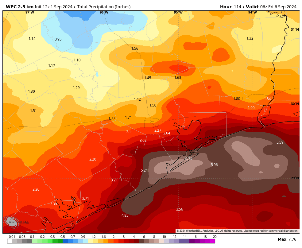
These rains will likely be most intense right along the coast, in places such as Galveston Island and points eastward to Port Arthur. For this reason, we are continuing to maintain a State 1 flood alert for coastal counties. This simply means that, in the stronger storms, there is the potential for some street flooding. We do not anticipate widespread, significant issues.
Rain chances will be lower for areas located inland of Interstate 10, but the entire metro area will have the possibility of seeing showers and thunderstorms into the middle part of next week as the pressure system continues to wobble near the upper Texas coast.
This means that our skies will remain partly to mostly cloudy, and this should keep daytime high temperatures in the vicinity of the upper 80s to 90 degrees through next Wednesday or Thursday. Sunnier weather should arrive by the end of this week, with diminished rain chances.
I don’t want to sell this too hard, but much of our model guidance is continuing to advertise the possibility of a cool front arriving by next Sunday or Monday. It’s far enough away to still have some doubts about whether this will happen, but it’s not impossible that we’ll see a couple of nights in the 60s with some drier air. I almost hate to write about it, because I don’t want to jinx it. I’ll have more on the likelihood of this front in tomorrow’s post.
Tropics
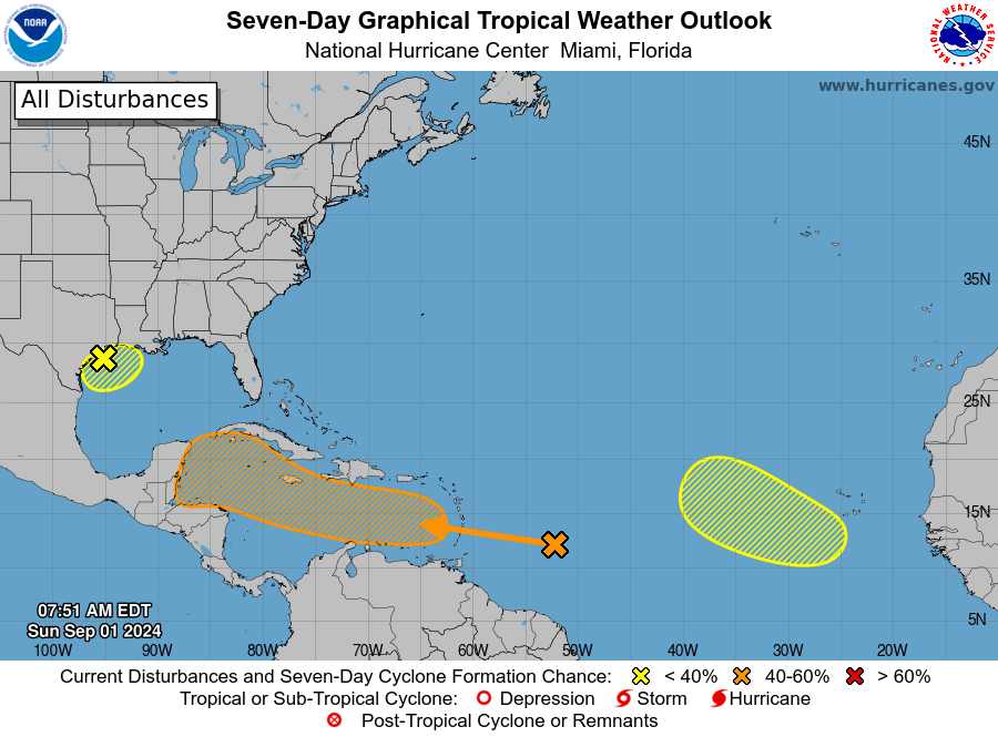
As for the tropics, we’re continuing to watch the Gulf of Mexico low pressure system. Because of its proximity to land, further development into a tropical depression is unlikely, but possible. There’s also a tropical wave the Atlantic Ocean nearing the Caribbean Sea. Not much has changed with this system. It’s possible that a tropical low eventually gets into the Gulf of Mexico, or it’s possible that nothing ever comes of this tropical wave. We’ll just need to keep watching for a few more days to see what happens. Matt will have more on this on The Eyewall this afternoon.

I, for one, welcome this rain to our area. My grass was starting to dry out in patches.
Wake me up when September ends.
10 points if you get that reference
I truly hope that “Summer has come and passed…” on this ‘Gray’ Day.
Man, this system has been frustrating for us. Just off 10 on the Westside and we’ve gotten 0.08 inches of rain out of these storms. The gage just north of us is over 2″. The grass us dying and these pine trees are stressed to the max!
Yes, we’ve had nothing but drizzle at our house. I know other folks have gotten a lot.
Well, it’s Sunday and the sun’s still shining here in Santa Fe. However, I know that Dickinson, which is just 3 miles to the north of us has been getting a good drenching every day. Boo Hoo!
“Ah, September! You are the doorway to the season that awakens my soul.” -Peggy Toney Horton
No rain at all in Galveston. Nothing.. not even a slight drizzle. I was bamboozled.
Yes, where’s all this widespread rain we’re supposed to be getting?
That low pressure area in the gulf has stayed off to the East. We have been on the dry west side of the circulation. Unless that system shifts to the west don’t expect to get anything more than spit showers.
Why is the rain that was associated with the low now hardly anything near the low? The only thunderstorms appear to be way southeast of the low over the central Gulf. Is there dry air getting mixed in?
We need rain!!
NE flow pulling in drier air, hence clean side of storm/Low
There was never a need for a stage 1 along the coast. Models were and have over done it with rainfall. Unless the low goes SW down the coast and get a burst of activity swinging in over the costal counties…remains to be seen.
If cool front swings in next weekend, that should push anything in gulf east of us. That’ll buy us some more time into September and get us closer to getting out of this season. Lots can still happen though.
The cool front can also lift a strong tropical system north depending where it is at the time the front pushes can be a factor
Yes, I think that is what happened with Hurricane Ike in 2008. There was a cold front on the way here but it wasn’t far enough down to steer Ike to the east of us. Instead, it pulled Ike directly to Houston. The best place for a cold front to be, if anything is lurking out there in the Gulf, is south of Houston to block it.
The NOAA had a Flood alert set until 11am, and is no longer in place. I agree.
It’s all mostly 10 minute rains every six hours here in Magnolia.
We got 4.5″ of rain last night in Baytown.