In brief: Houston will continue a string of hot days, but the nighttimes should become a bit more pleasant as well. A cool front on Monday will take care of that for us. Rain chances this weekend are mainly at the coast and mainly just scattered, and no real rain is expected next week. We have no tropical concerns in Texas.
There have only been two somewhat similar times that Houston has been through such a persistently lengthy stretch of hot weather so late in the season: 1904 and 2007. The 1904 stretch ended around October 12th, whereas the 2007 stretch ended on October 4th. So when can we get past this faux fall situation? Maybe soon? Maybe. But honestly, looking at the NWS forecast below, this string of upper 80s or hotter during the day may have another week left in it.
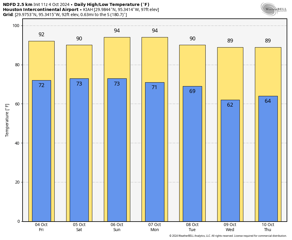
The good news in all this is that the nighttimes are running out of punch, and we should see lows in the 60s behind an expected cold front on Monday night or Tuesday. That front will also protect us from any tropical riff-raff in the Gulf of Mexico.
Today and Saturday
We already have a bunch of showers offshore this morning. We may see some of those work their way ashore through the day today. I have to be honest though: Consider yourself lucky if you see any rain.
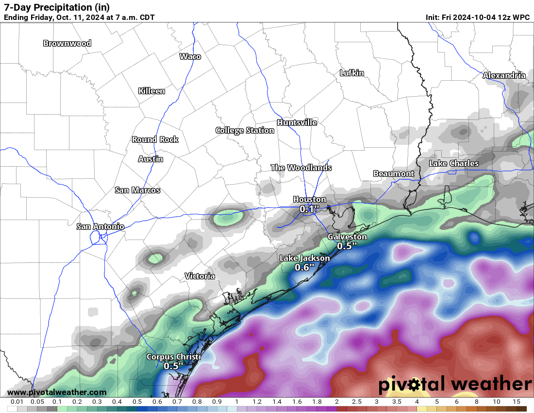
Tomorrow should play out similarly, though I think the coverage of showers will be just a wee bit higher. Still, for the many fun weekend events we have happening in the Houston area this weekend from the Dash tonight to Southern Smoke to the Komen Race for the Cure, our forecast is that other than perhaps a passing shower or two, conditions look fine. Just stay hydrated, as it will be warm and somewhat humid this weekend.
Sunday
Rain chances will begin to slip slide away on Sunday. Texans tailgating will be a bit muggy but other than maybe a passing shower, it should be fine. We’ll be back into the 90s for highs.
Monday and Tuesday and beyond
We will get one push of drier air late Sunday, followed by another, stronger push of dry air Monday night or Tuesday morning with an actual cold front. This is really going to take a bite out of humidity levels, and it will feel extremely comfortable by the time we get to Tuesday. Even with hot afternoons, it will be a decent stretch of warm days and cooler nights for mid to late next week. But again, no real rain chances.
Tropics
We’ve been covering the tropics extensively over at The Eyewall, and we will continue to do so through the weekend.
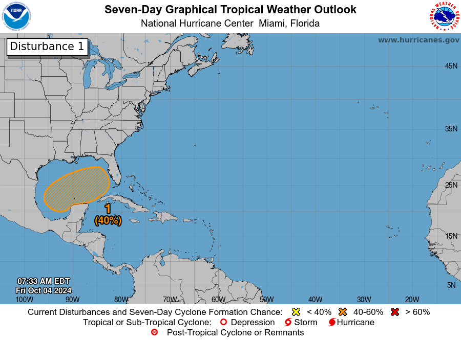
There will be a sloppy situation evolving in the Gulf of Mexico over the upcoming week where tropical development is possible to some extent. But because of our push of dry air to start next week, everything will get pushed east of us toward Florida. If you’re planning a trip to Florida, just keep tuned into the forecasts and maybe prepare for rain through Wednesday or Thursday of next week. Then hopefully things quiet down.

Good morning to my favorite guys! Thanks for the Florida weather mention. We are driving next week to see the SpaceX Europa launch, hopefully, on Thursday. Do things look ok for that? Thoughts?
To quote.
“If you’re planning a trip to Florida, just keep tuned into the forecasts and maybe prepare for rain through Wednesday or Thursday of next week. Then hopefully things quiet down.” end quote.
Carolyn,
The answer to this question is pretty much in Matt’s “Florida weather mention.” But it’s also on the weather app on your smartphone. Earlier this year I wrote about how to use your phone’s built-in weather app to get details about forecasts at specific locations. Most of the “what’s going to happen where I am” questions SCW readers leave here can be answered that way. You can read the post here.
Did you not read what was written about this: “If you’re planning a trip to Florida, just keep tuned into the forecasts”
Is it a faux summer or a faux fall? I think the former. And the longer it lasts, the faster drought conditions are setting in. Crackling and crunching my way on a bike through the scorched vegetation alongside the Terry Hershey trail on the westside, it’s the lack of rain that’s concerning. So come on weather gods, we’ve had our share of pretty skies – let it rain.
Better to ride on the paved trail then and leave the vegetation to recover.
With La Niña spiking, it looks like October will be warm and arrid. If we don’t get a pattern change soon, we will nosedive into a drought.
Better a drought than a tropical system beating us up.
So, you’d prefer a Beryl or worse to a period of dryness. Insane.
You do understand…no, of course you don’t, hence your response. There are gradations of precipitation generating systems. Of course, no one wants a Beryl or worse, but to ask for rain vs more dry conditions does not mean jump to the worst case scenario. Just like when people say it’s too hot here and others respond by going, “Well, at least we don’t get(insert Ice Planet Hoth conditions).” There is an in-between.
Go work on your reading comprehension, Tim L. All he said was dry conditions were better than a tropical system.
Someone else said desert. You said Hoth. Talk about extremes.
Sure is a lot of whining going on, especially when when the SE was just hit with a monster storm spun off the same CAG that’s down there right now. We should be grateful we were spared.
Beryl/Francine/Helene were tropical systems. Much better to have high pressure right now.
Get your priorities straight.
Already had One inch of rain down in Santa Fe earlier this morning.
According to long term jet stream forecast, it looks like between the 18th or 21st we may finally see a real cool front here. It will still stay largely above normal until early November though. If the forcast models are accurate than we may see chilly below normal temperatures arrive in early November. But I don’t really trust longterm models as far as I can throw em but my fingers are still crossed though. 🤞🤞
Some rain would be nice…I have not seen any in about 4 weeks now. And looking at the forecast there does not seem to be any real chance in the next 14 days either.
The ice planet Hoth ….I had to go look that wit up! You never know what you’re going to get here. Then there are the yahoos that prefer drought because the only alternative they can imagine is a hurricane. It is really up to nature (or the rain gods) how this goes, so why gnash over it. SMH as they say. Really enjoy the comment section.
Well, that’s hypocritical since you’re gnashing over it yourself.
Tropical systems don’t have to be hurricanes. They can be depressions or tropical storms.
SMH.
Hi planning a trip to The Bahamas from 10/6-10/15, would that are be affected too?