In brief: In today’s post we reflect on the horrors of the flooding in Central Texas on the Fourth of July. With our local forecast, we are going to see the return of fairly widespread showers and thunderstorms for a few days this week before coverage probably wanes some heading into the weekend.
Some Central Texas thoughts
Like so many of you, Matt and I watched the flooding tragedy unfold in Central Texas over the holiday weekend in horror. At last count more than 80 people have died, including some young people from Houston at Camp Mystic. As a father of two daughters, the single greatest fear in my life is that something serious happens to one of my kids. I cannot imagine the grief and anger and sadness and other incredibly strong emotions that affected family members are now feeling. You have our love and sympathy.
Matt wrote about the meteorology behind this historic flooding over on The Eyewall this weekend. The basic story is that the remnants of Tropical Storm Barry stalled over Central Texas, setting the stage for heavy rainfall not dissimilar to what the Houston region experienced during Hurricane Harvey nearly eight years ago. The rains were not as long-lasting, as Central Texas is further from the Gulf and an efficient source of moisture. But the rain was extreme, and rapidly led to catastrophic flooding.
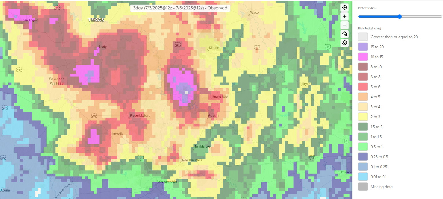
Overall we don’t believe the recent cuts to the National Weather Service by the Trump Administration—which are concerning for multiple reasons, and will negatively impact forecasting—played a significant role in warnings issued for this storm. The relevant offices of the weather service were reasonably well staffed, and they issued warnings in a timely manner. Yes, the overall rain totals in parts of Kerr County over-performed expectations, but flash flood warnings were in place for the region.
I think a major part of the problem is that these floods developed after midnight on a major holiday. Additionally, the most affected areas were largely remote, with some places lacking even a cell phone signal. So although there were flash flood warnings in place when the waters began rising, they were not seen or, in some cases heeded. That is not to say the forecasts were perfect. In an ideal world residents in these areas would have had days of warnings, rather than hours, but this is not always the case in extreme weather. For example, Harvey’s flooding was relatively well forecast in Houston before landfall, but the derecho in May 2024 was not well predicted. Meteorologists are not perfect, and neither are our forecasts.
A couple of readers have said they were disappointed that Space City Weather did not sound the warning on these storms. I hear you, but I would like to say a couple of things. Firstly, Kerrville and areas surrounding it lie very far outside of our forecast area. They are 250 miles from Houston, and our focus is this metro area and surrounding counties. We are intensely local. If this were an Austin- or San Antonio-based site, it would be a completely different story.
Second, when I looked at all of this on Thursday morning, the forecast for heavy rainfall did not look overly extreme in Central Texas. Some bad rains, certainly. But not what ultimately transpired. If we had really known what was was about to happen early on the Fourth of July, if we could have saved lives amid this awful natural disaster, we would have shouted it from the rooftops, even if it was far away in Texas. The reality is we did not. I dearly wish it were otherwise.
Monday
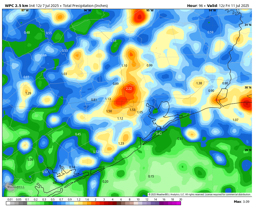
After largely rain-free conditions across the region this weekend in Houston, the atmosphere above our area will become more favorable to showers and thunderstorms for the next several days. In the absence of high pressure, with the region open to the Gulf, rain chances will be on the order of 50 percent or higher on Monday, and likely for much of the coming week. Chances will peak during the late morning and afternoon hours as showers and thunderstorms spread inland. These storms will definitely be hit or miss, but where they “hit” they could quickly produce on the order 1 inch of rain or more. High temperatures will be in the low- to mid-90s, with lows in the upper 70s.
Tuesday and Wednesday
Rains likely peak on Tuesday and Wednesday, with chances of 60 percent or higher for most of the area. Again we expect some pockets of heavier rainfall in which 1 to 2 inches may fall, whereas the vast majority of Houston will probably see less. Daily shower chances will help to corral high temperatures in the lower 90s for much of Houston. Although we don’t anticipate significant flooding, we are going to be watching this setup closely.
Thursday, Friday, Saturday, and Sunday
There is not yet a clear signal for when high pressure will return in force for the greater Houston region. It may happen as early as Friday or Saturday, or it may not be until some time next week. As a result the forecast for this weekend is kind of fudged. Generally we can probably expect high temperatures in the mid-90s. Let’s go ahead and ballpark a 30 percent chance of daily rain showers, but if you asked me how confident I felt in that I would say not very. We’ll likely have to adjust that number upward or downward as we get closer to the coming weekend.
Atlantic tropics
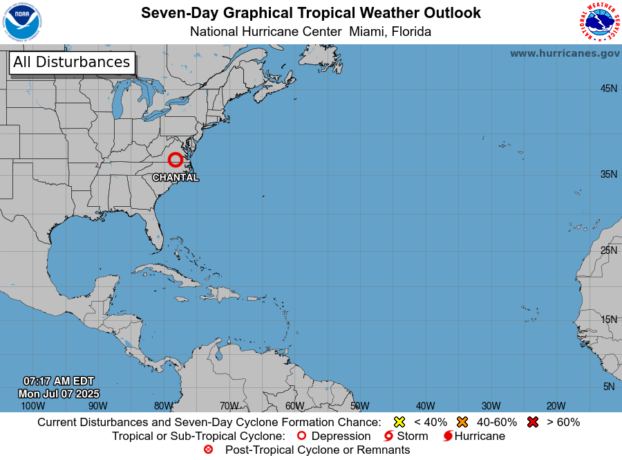
Tropical Storm Chantal has weakened to become a depression over the eastern United States, and is on its way to dissipating. Beyond this, the tropics are quiet. With another large plume of Saharan dust moving off of Africa, I think it’s most likely that tropical activity remains low over the next week or so. In any case there’s nothing I’m watching that is giving me too much concern.

Casting blame for natural disasters is incredibly ignorant. The hubris of our species is mind boggling these days. Keep up the good work Matt and Eric, those with a shred of sense know there is no one to blame for these events.
I 100% agree with T. WHITE!!!
THANK Y’all for everything you DO!
Thank you for always being open, honest, and unbiased in your emails/posts. Thank you for how you support the City of Houston and immediately surrounding areas. It can’t be an easy calling in life, but know there are people who appreciate and support what you do.
I couldn’t imagine placing blame on you. If there’s one thing I’ve learned over the years, it’s that y’all are better than most at what you do. More importantly, you consistently try – and that’s more than most can say. Thank you.
Thank you for doing such a great job! I first found you during Harvey. We had no electricity and I discovered your site while trying to find weather info. after charging my phone in the car. I found your forecasts to be the most accurate and enjoyed your thoughts and personal connection. You have continued to be my go to …
You and Matt are, and will always be, my ‘go to’ weather guys, always injecting a note of sanity and common sense into your work. The latest example is your refusal to use the old ‘budget cuts’ scapegoat for this latest tragedy. I know that technology is important in your work and I am certainly no expert in such things, but in this case it seems that a $2.00 rain gauge located up river and someone looking at it to sound the alarm would have saved a lot of lives. As you noted, the time of day of this weather event, the holiday weekend and the lack of cell towers in the rural region all played huge roles. Thank you again for all that you and Matt do for all of us.
Thank you for being here. Your words about the Hill Country tragedy rang true. This flooding was unprecedented. We can only pray that these families who lost children and family will heal. Again, thank you for being here
If that unprecedented tragic event could have been predicted, SCW would have warned about it. I immediately thought that while reading about the flooding this weekend. You guys are the best at what you do. You set the bar. If SCW didn’t see it coming, it wasn’t possible to. You both live for weather forecasting. That is apparent in your posts and we appreciate it.
NO MORE RAIN.
Let me take the other side for our local area – yes, let’s have some light rain.
At the least, the cloud cover will knock off a few degrees off our high and save the wallet the extra expense as a side benefit.
That’s called the dust bowl, no thanks. I’ll take a moderate amount of rain pretty please
First and foremost. Thank you both and all of the individuals that work so hard at SCW to keep us weather informed. While others are still sleeping your team is up early keeping all of us weather wise. I do believe if you had the opportunity to notify and inform people your team would have done so. Please don’t let a couple of negative comments affect anything you do. You do a wonderful job and all of you should be proud of yourself for the job you do.
I’m going to be watching Daniel Swain’s analysis today on Weather West. I’m gathering from his posts on X that he isn’t buying the view that this event has anything to do with NWS staffing. This tragedy reminds me of the 1972 flood catastrophe in Rapid City SD. A nighttime event, nearly unprecedented rainfall rates on hilly terrain upstream from populated areas, unwise development in the floodplain.
Swain is also saying that NOAA is proposing gutting NOAA.
I read that in one of the documents but I thought, ‘well maybe they are just trying to preserve the most critical infrastructure from further cuts’. That was the only rationale I could come up it.
Wrong again.
No more weather research. IDU it. Why would NOAA propose to gut itself?
He reiterates that in today’s presentation, related to the prospect of eliminating research that would improve the American high-resolution models that performed well in anticipating this event.
As an 82 year old widow, I am thankful for your forecasting reports. Your accuracy has kept me at home many times and kept me safe. You are not God and as humans, there are mistakes. But, you are far more accurate that the television stations. Keep up the good work and protecting the Texas Gulf Coast Area. We need you and appreciate you.
Anyone giving you grief about not forecasting weather in Kerrville is out of their minds. I mean, c’mon. And the number of social media and regular media posts I’ve read of folks who were ALERTED and chose to not do anything means no matter what website or blog also issues a warning it may not be believed or acted upon. You are right, Eric, your focus is on Houston and surrounding counties, not the entire state.
I have referred Florida friends to The Eyewall with that site’s focus on hurricane development and activity, but the storms on the Guadalupe aren’t that.
What a thoughtful, well-written and measured article. I think you voiced exactly what everyone is feeling on behalf of those parents and families who have stayed on our hearts all weekend. Thank you, Eric.
I agree with Laura Mc as well as many others here. Thank you Eric, Matt and the SCW team for everything you do for all of us. Thanks for sharing your pained heart too. The ripple effect of a tragedy anywhere in the world touches us all even when we think it doesn’t. We’re all connected. And this one was in our home of Texas. Please don’t blames yourselves. Those who lost loved ones are beyond consolation right now but not beyond the reach of sincere heart felt prayer. Allow God to do the rest.
This was a certainly horrific circumstance and thoughts and prayers are for those affected. Thinking this through, I’m sure the finger pointing and subsequent lawsuits to follow, but how to prevent something Iike this EVER happening again. How do we make sure we receive the email blast from the NWS or local emergency authorities for weather warnings? I think a basic here is how you make sure you get these warnings when issued will help. Thanks.
I am impressed with the capabilities of Weather Bug application and enjoy the updates they give me. They’re pretty up-to-date with the latest emergency/warnings and have it on a good map.
Remote areas with lack of communications system is a huge problem! Alerts were posted on X, but how many central Texans use X social media platform?
Thank you for your always clear and well considered forecasts and updates. You are much appreciated.
If you don’t mind I’m going to give my 2 cents,for what it’s worth. I’ve lived on the gulf coast most of my life, I’ve have ridden out hurricanes as a child starting with Audrey, to last year Beryl, have always chose to stay,call me insane, most likley I am,even last year, I drove from Kerrville to Kemah,to take the canvas off our boat, then stayed and rode out Beryl on the boat. I’m 71 years old,and I will say it’s not for the faint of heart, I do not recommend that anybody ride out a storm when you are told to leave. I did recovery help after Ike. Living only 5 blocks from the Guadalupe, we started getting warnings at 1:00 the afternoon before, of possible 3in, up to a possibility of 7in, I’ve seen the river rise 3-5 ft with that amount of rain, we sit on top of a hill so it does not effect us, but doing the night I checked our rain gauge and it was at 10in, about 4:00 I heard what I thought was thunder but it was lasting to long, I’m not realizing it was a wall of water. Our hearts go out to the the families of lost ones, I’ve seen there faces,I’ve seen it before, but it’s not do a to a failure of the weather warning systems, and it’s sure not a failure of you guys. Now is not the time to start pointing fingers, but it’s a time to heal. Texas storm Chasers does a great job up here,just as y’all do on the coast. As it is said,bad things happens to good people.
On top of this tragedy must be the awful experience of finding the bodies, particularly of children. Those who search and find the missing need to receive as much solace and comfort as do those whose loved ones have had their lives cruelly cut short.
What are your thoughts on the “Rainmaker Company” and the fact the CEO admitted to Cloud seeding the days leading up to the flood? I am not claiming this caused the flooding, it was obviously the tropical storm, but cloud seeding definitely couldn’t help…
@Taylor … confirmed by a few experts “no influence”.
Read the article “Rainmaker CEO To Speak Publicly Amid Cloud Seeding Scrutiny Over Texas Floods” at the Dallas Express.
Good info , to include quotes from “Houston meteorologist Travis Herzog (whoop!).
Thank you! Was hoping to find something addressing this, will check it out
Thank you for providing a rational, fact-based analysis of the terrible weather events from the weekend. I appreciate your level-headed approach as always, and especially so in today’s hyperpoliticized media climate, which can overshadow what the focus should really be on – helping and comforting those affected by the storm.
I remember the initial rainfall projections for Harvey being about half of what ultimately pummeled my neighborhood. But you guys did nail its track. If ever there was an argument for “we need more funding for weather research, not less”, it’s this latest tragedy.
Also it’s way past time for a flood warning system if you insist on having camps near the river. I get the appeal. I grew up in the Hill Country, and did summer camp near the river. Kerr County did vote down a warning system. I hope they reconsider.
Many campgrounds in US are in super floody riverside spots, and I guess forecasts give them false alarm every few years. Of say 100 river campgrounds in a metro after decade of false alarms I guess 3 will have lazy dumb manager and not evacuate despite say 5% risk of mega flood. And city officials over complacent to not yell at them.. We have no TX or US law saying no using this land or always evac at slight risk.
So normal dumbness led to this. I don’t see way to avoid in future. My parents have lost a camper to rising river water, I guess it is common to have middle of night shouting from a camp manager about river rising, but in chaos and loud storm some campers and vans get left — river campgrounds are risky?
@M … yea, Bryan Norcross (chief meteo…) mentions this (lack of evac management) in addition to “why” this flooding occurred.
Find the video, “How remnants of Tropical Storm Barry helped fuel deadly Texas flooding disaster” at foxweather dot com.
The forecasting was not the problem. The alert system was the problem. It’s a simple fix. Put float gauges on the river. When the gauges rise X amount in X amount of time SIRENS go off. People might not pay attention to cellphone alerts in the middle of the night, but Sirens they will. You don’t need cell service for a SIREN, only electrical service. Bill Mc
No snark or ugliness, real questions
Sirens where? How many? What’s the square milage of effectiveness? Who will maintain them? Is this system used elsewhere?
Could be a good safety device/upgrade to any river-side campground within X% of flooding risk. Could be a selling point for any camps near there going forward. I wonder how much it would actually cost to have a private-public partnership for places like camps in the future. Sad tragedies had to happen for considerations like this to take place, it is crazy how high floodwaters can rise quickly, but I know municipalities have the sirens up north for tornadoes.
But can sirens cover ENTIRE counties, even rural ones, and if beyond hearing range won’t people feel safe cuz can’t hear sirens?? I’m MOSTLY for sirens in giant metros, but can cities of 1000 people afford such a system. To be math focused, annually, 3m US people die of disease partly due to little medicine, 4000 kids die on US roads (20000 adults), so not sure 50 kids in riverside campground floods once a decade are top of money priority.
It’s hard to put into words the depths of my gratitude for this site every single day, both for personal and professional reasons. Thank you for always being the voice of logic and reason, even when it comes at a high cost.
As bad as this event was, I vividly remember the 1957 Texas flooding which affected most of the state:
https://www.tribtalk.org/2018/11/15/the-floods-of-the-1950s-and-the-floods-today/
Floods and drought are a fact of life in Texas.
Yep, on July 17th, 1987, the Guadalupe River actually rose 6 feet higher than it did with this flood. The worst flood in Texas history was actually in 1921 when 251 people died in the San Antonio area from a tropical storm I believe.
I’ve noticed people from outside the general area asking why campers, tourists, and weekenders didn’t respond to the alerts that were issued. It’s a fact that cell phone coverage can be spotty or non-existent in large swaths of the hill country. When I stayed in a cabin on the Frio near Concan, I had to leave and drive up the road to a cemetery gate, or to the top of a hill, to find coverage. Even now, when visiting a friend who lives atop a hill between Kerrville and Medina, I sometimes lose coverage and have to find a different location to connect. Two years ago, a complete lack of coverage between Sisterdale and Kendalia caused no end of frustration when I had car trouble.
When technology-based solutions — even a system of linked sirens — are proposed, they sometimes assume more than is warranted about the presence of an infrastructure capable of supporting them.
Beyond that, there’s a human factor to consider when it comes to phone alerts. Many people who visit the area purposefully turn off their phones as a way of escaping, and some of the camps along the river have had “no cell phones or electronics” policies for their campers. A first step might be a redesigned system that combines human ‘watch standers’ with existing technology. When sailing offshore, someone always is standing watch. It might work on land, too.
I have heard a lot of people blaming the cuts to NOAA for this tragedy, and it is so annoying. It’s like people forgot that weather forecasting was always shotty at best long before the cuts. I have no idea where this idea that weather forecasting was always perfect before because it wasn’t. Hasn’t anyone heard the long time running joke about how being a weather man you can be wrong everyday and keep your job? Lol
People have always been caught off guard by spontaneous weather disasters and always will. There is no way a massive flood like the one that just happened in Texas could have ever been predicted with percision accuracy. I don’t care how advanced the weather forecasting is.
We should always strive to improve forecasting and get better at it. And we have. Obviously it’ll never be perfect, but we can’t let perfect be the enemy of good, and we should continue to improve. Cuts to these agencies hurt improvements.
I wonder if the campers in Kerr County would have paid any attention to weather event alarms if there had been any, forecasting is notoriously inaccurate and most people would just shrug. Today we were advised by this and other forecast sites there would be t’storms and heavy rain, we heard thunder but got no rain. How can we improve forecasting so no one will ever say: Oh, crying wolf again!
Remember, there were thousands of campers along the river, and most if not all are not going to pay any attention to any kind of alarm and will have no expectation of accuracy when moving away from potential floods is just not practical for yet another false alarm. How can forecasters pin-point weather events with any accuracy to forestall a tragedy like this happening again? How many of us just don’t pay attention to forecasts any more?