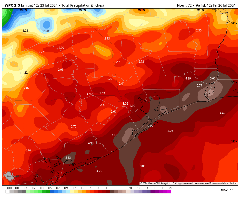
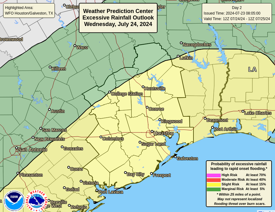
In brief: Houston faces three days of widespread showers, with the potential for heavy rainfall and street flooding, before conditions start to ease heading into the weekend. The entire metro area lies under a Stage 1 flood alert through Thursday, although the potential for heavy rain this week is highest near the coast. That’s where we expect the greatest accumulations, with 6 or more inches possible in some locations.
Tuesday
Showers have developed near the coast this morning, at sunrise, and are making their way inland. Coverage of these storms may widen for areas south of Interstate 10 this morning, and this may prove impactful during the morning commute. Some street flooding is possible. Later today we can expect widespread showers for much of the area, with embedded heavy rainfall through the daylight hours. Please be weather aware as you get out and about today.
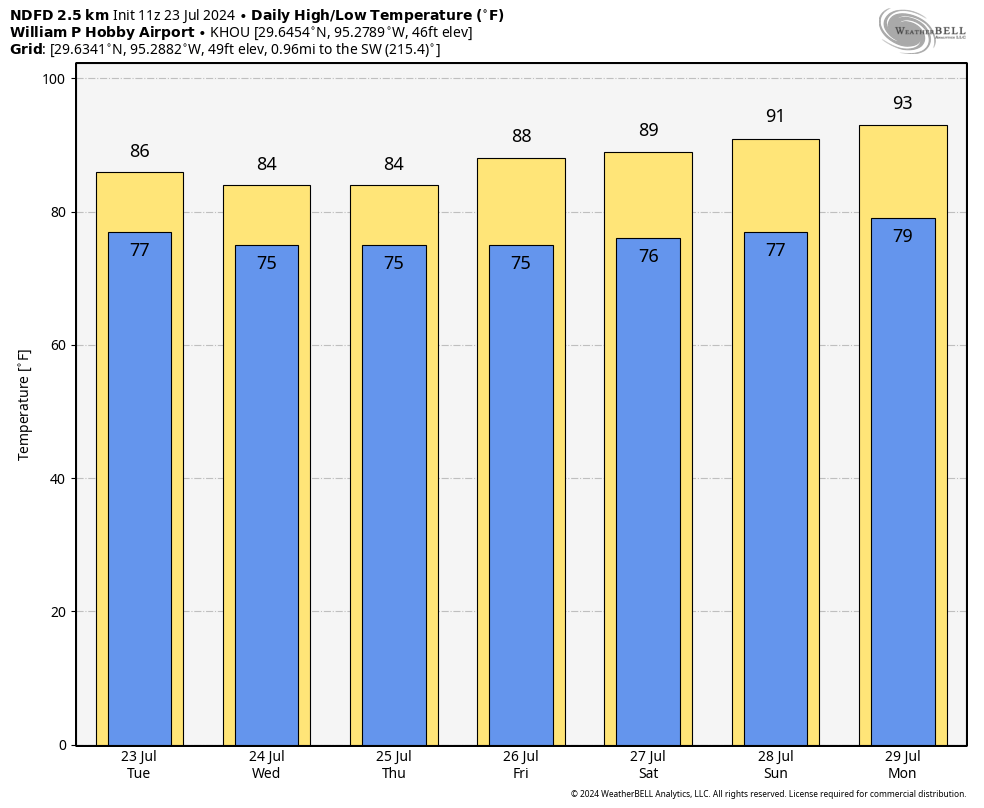
The coverage and intensity of showers today should wane as we get toward sunset, but some light to moderate rain will still be possible overnight. Highs today will get into the mid-80s for most locations, although far inland area (with lesser rain) may reach 90 degrees. Winds will generally be light, from the east, at 5 to 10 mph. Lows tonight will drop into the mid-70s.
Wednesday and Thursday
These days will both see widespread coverage of moderate to heavy rainfall, with the highest totals likely along and south of Interstate 10. Most of our modeling continues to paint coastal areas, from southern Brazoria County to Galveston Island, and up the Texas coast to Port Arthur with the greatest accumulations. Heavy rainfall is certainly possible for areas further inland, such as Katy, Tomball, The Woodlands, or Kingwood, it’s just that widespread coverage is less likely. In any case, be prepared for travel delays during the heaviest storms; but also understand that not everywhere is going to see heavy rainfall nor serious impacts.
Rain totals through Thursday night should be on the order of 2 to 4 inches for areas north of Interstate 10, with higher end totals of 6 inches or greater possible south of Interstate 10 and especially along the coast. We should also continue to see quieter nights in terms of storm coverage.
Heavy rainfall remains the big threat this week, with the possibility of damaging winds and other severe impacts much lower. Highs both days should be in the low- to mid-80s for most locations. Evening temperatures will be, dare I say, almost pleasant?
Friday, Saturday, and Sunday
Rain chances remain high for the weekend, albeit with less coverage and storm intensity with each passing day. By Sunday or so, only about half of Houston is likely to see rain, and accumulations should be modest. Daily highs will correspondingly rise from the mid-80s on Friday into the low-90s by Sunday.
Next week
By Sunday or Monday, we’ll start to feel the encroaching high pressure from the eastern United States. This will lead to sunnier days—we can probably expect mostly sunny skies most of the time next week—and warmer temperatures. Highs will likely start out in the low-90s next week, but I suspect we’ll be in the mid-90s by the second half of the week as we enter August. Rain chances are not going to go away entirely, but they’ll be greatly diminished, and likely to only occur during the afternoon along the sea breeze. Summer is going to summer in Houston, as it does in August.

Had some decent rainfall yesterday afternoon and a little bit in the early evening, here in Magnolia.
Looking at NWS radar now, this morning is a repeat of yesterday morning, so suspect that today we will have a duplicate pattern of rain movement … though I’d say the rains will arrive sooner (late morning?).
No alerts for our area (yet), per NWS and Wunderground. So nothing more than soggy pastureland for us. The cooler temps are a nice side effect !
If there is enough rain this week, we shouldn’t get to the mid 90’s next week. Grounds will be wet and cool and thus not allowing the temps to climb so high as last year. Then that will only give us 3 weeks left in August at which point I suspect a cool front may make it all the way thru next time. Hang in there y’all!!!
Had some very brief sideways rain yesterday and that was it, but those gusts took out Beryl-weakened limbs and fencing in a few places, so be aware of that, too, as you’re out and about and in your yard. Be safe out there.
Don’t agree with the coastal areas getting all the rain. This mornings rains died out as they were moving inland. Looking at radar there isn’t much ooph going on. Models over doing it
SCW took a lot of heat for downplaying Beryl until it was too late. Early models showed it to be nothing more than a mild storm that would miss most of Houston. I wouldn’t be suprised if now they want to err on the side of caution and overstate things now so that the same thing doesn’t happen again. Either way, it doesn’t hurt for us to be overprepared for any eventuality.
So anti-hype that they went too far and left us out to dry (or rather the exact opposite) with Beryl.
I know this stuff is hard to predict but they’ve gotten away with too many very wrong predictions recently.
“Gotten away with?” You do realize that this website costs you nothing but your time, right? You can look elsewhere if you think they’re incorrect.
Hey, @Harmanny Music … I do that … refer to multiple websites. And all are no cost.
Guess what – the Ventusky weather website predicted the EXACT path of Beryl days before it was in the breadth of the Gulf. (I discovered that website from another poster in here, when US sites predicted a Mexico path).
Seriously, I still have the screenshot where it shows the path turning northward, and crossing directly over the Houston area.
It used a non-US model, which I suspect why no US weather folks consider it (using Euro models).
“…but they’ve gotten away…”
What an extraordinarily childish remark. Do you really think someone owes you? This is a free weather ‘forecasting’ site, did you not understand that?
This site is no better nor no worse than any other forecasting site – it is just that – ‘forecasting’. No one with any sense ever relies on weather forecasts.
We’re supposed to be headed on vacation Thursday morning, flying out of Hobby. Very stressed and worried right now 🙁
Try owning a business that can’t get work done with all these rains. I’m sure your little vacation will be fine.
For some people, a vacation is the result of weeks and months of hard work and sacrifice all year, saving every penny, dipping into a limited number of PTO days, and something special for their kids. To see the “little vacation” ruined due to grounded planes, canceled flights that then have a ripple effect into the rest of the trip can be devastating. I’ve known people lose thousands of dollars due to awful cancellation policies, or half the vacation spent sitting in the airport. Have some compassion and empathy, because your “little” personal business problems may seem trivial to someone else.
Probably difficult for you to fathom, but these rains affect my ability to work. Which affects my ability to pay my employees. Which affects their ability to pay rent and buy groceries for their family. So spare me with the “have some compassion line”. Enjoy your steady W2 paycheck though. And I’ll continue to provide the livelihoods of 22 families.
In a word: diversify 🙂
There is no point playing “Who wins the biggest woe.” Stress, anxiety, and suffering are relative. You don’t get to tell other people they’re not allowed to be worried because you believe your worries are bigger. That is a petty and pointless attempt to make yourself feel better by putting someone else down. I’m sorry for your troubles.
I’m leaving on Thursday to go bury my late grandmother. I too am anxious about my travels with this rain and was hoping Anthony got an answer to his question to quell my own stresses.
Anthony, one strategy I’ve used in the past is to book a hotel very close to the airport for the night preceding the flight. It gives you a great buffer that’s worth the additional expense. Good luck and hope your vacation is awesome! Send us a weather report from your location:)
Summer comes only once a year for just a brief time, it is disappointing to have it ruined by so much rain and hurricanes.
Guessing you’re new to the area, let me tell you though, summer comes 6 months a year here, so it ain’t exactly brief. Also no one will argue the hurricanes, but rain in the summer here is a saving grace. You’ll figure out our weather, it’s just 2 seasons lol. Welcome to space city!
Will this weather effect the airports on Thursday and Friday? We fly out of Hobby on Thursday morning.
I’m flying out of Bush, myself. I’m wondering if I should reschedule to Friday.
With the clouds and rain our daytime highs will be well below normal the next few days. July, 2024 will go down below average which is a blessing in Houston, Texas. Hopefully August won’t be a blow torch and we will look back on the Summer of 2024 as the “Year Without A Summer”. Relatively speaking for us…
This is why I never take the climate predictions (temperature and precipitation) three months out seriously. Back in April/May the prediction was for a warmer than average July. It now appears it will be cooler than average. They are not very accurate.
Since the beginning of the year the predictions have been for a wetter than average July and August.
So glad I rescheduled an important doctors appointment because I didn’t want to drive to the med center in flooding rains, yet we haven’t had a single drop of rain anywhere near our house in the Heights. 😵💫 So tired of these flooding predictions that end up being nothing burgers. I don’t know if it’s the humans doing the analysis or the models, but forecasts are just NOT RELIABLE any longer sadly.
Can you guys toss out the models that show the heaviest rains “along the coast” and “south of I-10”? Kingwood is neither and here we are getting absolutely blasted for a second straight day.
If you have any rain to spare, we on the west side will take it. So far, zilch!
Man I’d love to share it. Believe me.
Hey @Derek … visit multiple weather sites – don’t rely on one single opinion!
I just want to put it out there that Eric and Matt and everyone associated with SCW do a stupendous job! If you as an individual think that it is there job to keep you from being impacted by weather you are doing them and yourself a disservice. Eric and Matt aren’t an individual weather service tailored to your specific circumstances and situation. All of us as individuals have to own our particular circumstances and situations. You can do everything right and sometimes you still get dunked on. Just the way it goes sometimes and you notice that both Eric and Matt are not grinding on their own personal issues which they have gone thru. I think they are stand up examples of getting thru the issues we have with weather here and should be emulated. Bravo you guys!!
Here’s some q&a for your next session. What variables are involved in forecast models? Is our current solar maximum cycle included? Geomagnetic activity as a result of solar winds? Or is it just temperature, winds, pressure systems locations etc? Curious why spaghetti models are all over the place early in tropical storms but seem to align later. Do some models put more emphasis on certain variables early on?
I’ll be flying out of state on Thursday morning. Should I risk this?
Are there hints of extremely excessive rain? I noticed Conroe has over 5″ already and we still have the rest of the week to worry about. Wondering if this is another 20″ thing for Conroe (which resulted in lots of flooding in May). They started their release and sadly, the City hasn’t indicated whether they are opening the gates at Lake Houston, which means worse flooding. NOAA totals thru Thursday are blown away already and it’s only Tuesday and not done at that.
We’re getting about 2″ per hour up here in The Woodlands. 8″ so far in the past 48 hours.