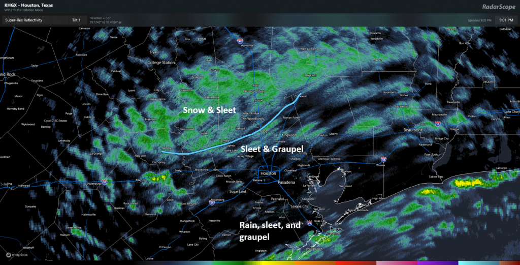
In brief: Houston’s forecast appears mostly on track, with a definite trend toward the heaviest snow and sleet emerging south and east of Houston by Tuesday morning. Accumulations may be as high as several inches under the most persistent bands, with a general coating to few inches elsewhere. Winds will gust near the coast Tuesday morning as well, and a very cold night still looks on tap tomorrow night.
Happening now
Well, our much advertised winter storm is underway across the Houston area. We’ve seen reports of sleet, graupel, rain, and snow across the region. We seem to be settling down into a tiered setup now with snow and sleet north and west, sleet and graupel in the lighter precipitation, and sleet and rain near the coast.

That area of snow and some sleet occurring north and west of Houston is going to gradually fill in and drop south and east through the night. As it does so, we’ll pick up some accumulating snow. As it gets closer to the coast and the potential for banding gets underway, that’s when we may see locally heavy snow anywhere from I-10 southward to the coast.
Forecast for the night
So before 3 AM, look for this potpourri of precipitation types. Again, plain rain should be expected in spots near the coast especially. This is not a surprise and was anticipated ahead of time. After 3 AM, there will be a transition to all sleet and snow and eventually just snow. There is a good chance we will wake up to snow falling tomorrow, although how much on the ground is an open question with a few possibilities. Snow should end from northwest to southeast after 9 AM tomorrow.
Why have we been kind of cagey on snow accumulation numbers?
Those that read us closely can tell we’re throwing out various accumulation numbers based on model data and National Weather Service forecasts but we’re not exactly confident. Now, the event is underway so we should be highly confident, right? Not right. The SREF is a short-range ensemble model, meaning it’s run multiple times with varying snapshots at the beginning to produce a more realistic spread in outcomes. Basically, we want to see how bad or not bad it can get. As of the 3 PM run this afternoon, this model showed snow totals ranging from nada to as much as 7 inches at Hobby Airport.

Now, Hobby Airport almost certainly won’t get 7 inches of snow. It probably won’t get 0.0 inches either. The average on this particular model is around 2 inches, which is reasonable, but there is such a spread in options here that it doesn’t necessarily inspire much confidence. The trouble with this event is that we’re dealing with a wintry mix at the start, we don’t know where banding will establish, we’re in a place that rarely sees weather like this so it’s far outside of the bounds of the climatology (normal) these models use, and we have the Gulf of Mexico in our backyard. All that to say, this stuff is hard. If you want snow, hope for the best. If you do not want snow, hope for the best. May the odds be ever in our favor.
Sleet versus graupel
Here’s a true story. Back in my on-air broadcast days in Utica, NY, I once was describing a day where we had a bunch of graupel fall in Upstate New York and explained what it was. Immediately after the news, I received a call from an older gentleman who told me he had a dictionary in front of him, couldn’t find the word, and proceeded to lambaste me for making up words. I can assure you that it is a real word. So what is it, and how does it differ from sleet?

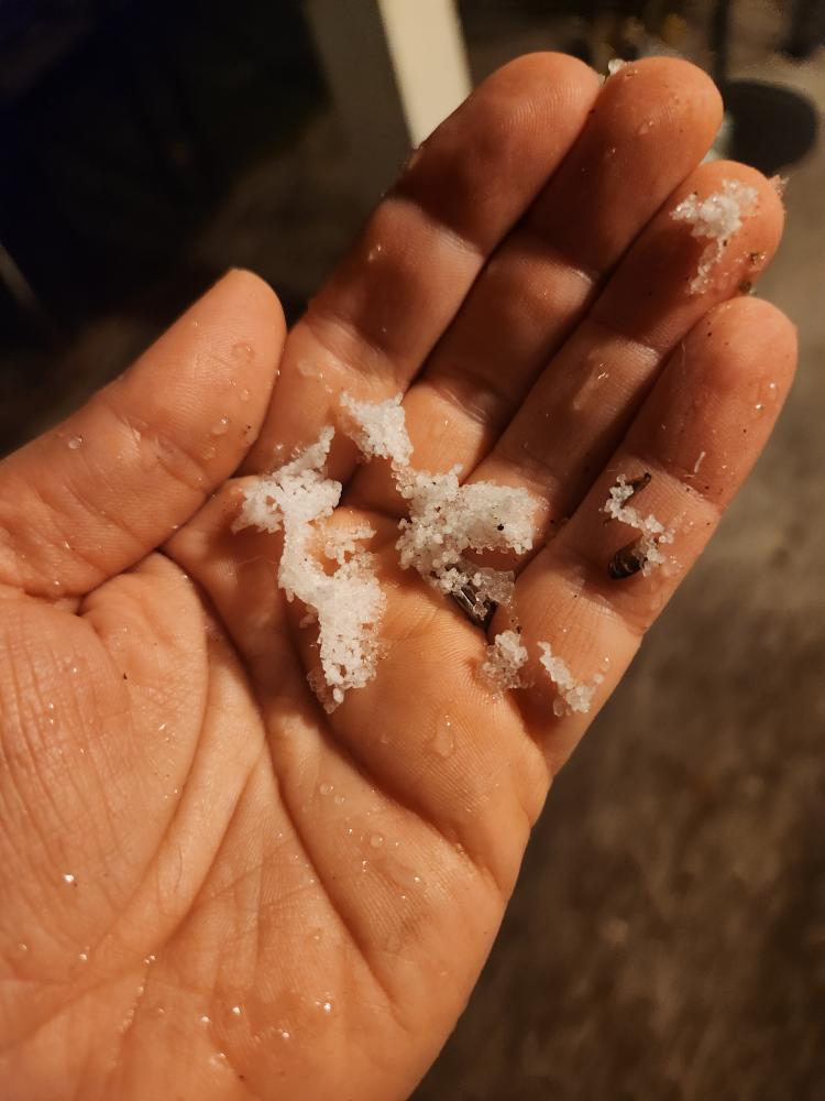
We’ve gotten reports of sleet and pictures of basically tiny “balls” of ice across the area. When you look at the pictures, however, they look more like Dippin’ Dots than ice pellets (sleet). That’s a tell-tale sign of graupel. The differences? Sleet is straightforward: A snowflake falls, hits a layer of milder air above freezing, melts, and then refreezes in colder air below that, falling as quite literally an ice pellet. Graupel happens when you get water droplets that are still liquid below 32°, (or what is called “supercooled”). The supercooled water droplets collide with and freeze on a snow crystal, a process called riming (which is a homonym of “rhyming”). They basically fall to the ground as snow pellets. They tend to be whiter (hence Dippin’ Dots-like!), whereas sleet is clearer. Sleet melts in your hand, whereas graupel may fall apart or crumble in your hand.
What many of you may have reported as sleet tonight was actually graupel. This is a weird storm because we have a pretty intense layer of dry air from the surface up to about 5,000 feet and from about 12,000 feet up to 30,000 feet. The region of the atmosphere where snowflakes will grow is up above 15,000 feet, so we’re seeing a bit of chaos ongoing above our heads. As the night goes on, this dry air will erode as the atmosphere cools, leading to more regular snow.
Eric will have the latest for you in the morning. Stay safe, stay off the roads tonight, and we’ll see where we are tomorrow!


The radar showed snow over Sweeny just 20 minutes ago but it didn’t do nothing. I fear the atmosphere just above may be to dry and is evaporating the precipitation before it reaches the surface at the moment. I’m sure that will change after midnight.
Thanks for graupeling with this article so late.
☺️
User name checks out.
Well played. 😂
Anybody thinking this could be a total bust? Should be seeing lot more stronger echos on radar. Dry slots embedded within. Hope this flips a switch and blows up overnight and dumps it all on us.
No. Geez its just gettin started! Im sure someone is gettin something somewhere..🤷🏽♀️
It was a bust in south Houston. Barely a dusting. The roofs are white but it wasn’t even enough to cover the grass.
Snow in historic Montgomery, Texas tonight (birthplace of the Texas flag).
Test
When my kids were young and I witnessed something objectionable, I’d say, “What the crap is this crapping crap???”. Now they’re older and on their own, and I don’t have to filter like I used to. But I’m going to change my catch phrase to, “What the graupel is this grappling graupel???”
Me again. This hasn’t been answered yet but I’ll edit to include graupel now.
How much graupel will fall at exactly 9:03am on my front yard by my basketball goal.. but specifically on the right side of the goal by the northeast corner of my grass?
Thanks in advance.
Grew up on the other side of Syracuse (near Watertown) for 18yrs of my life & I can’t say I’ve ever heard the term graupel. Wish my parents were still alive to see if they ever heard it lol!
How much graupel will fall at exactly 9:03am on my front yard by my basketball goal.. but specifically on the right side of the goal by the northeast corner of my grass?
Thanks in advance.
Graupel is a German word.
Which is why Tomball is covered in trample.. knew it.
See auto correct doesn’t like graupel either. Darnit.
Sure, you are right! Cassell‘s German – English Dictionary even makes no difference between hail and sleet, both is Graupel…
Prayers for the water pipes.
Discovered yesterday my brain has not gotten over the 2021 bursting pipes experience.
Well that’s a form of wintery precipitation I’ve never heard of, I guess I’ll have to graupel with this new knowledge.
as of 10p in Lake Conroe snow flurry and 1/8 accumulation thusfar on non-paved surfaces. Still melting on paved surfaces and stepping stones in the yard.
Thanks for the precipitation photos and explanations. You and Eric are THE BEST!
Thanks for all of your hard work guys!
Sleet in NE Brazos county – sticking to raised surfaces. Not sticking on ground. 10:15 pm
We live inside the loop on the northwest side. It looks completely dry for us in the next few hours. I guess we’ll see but this could be much ado about nothing which would be fine with me after 2021!
Graupel here in Humble so far!
Shout out to all the staff sleeping overnight in the hospitals to keep our loved ones safe and healthy.
Matt, what you are calling graupel, my dad who grew up in rural Oregon called “corn snow”.
Nothing closes for snow in Utica, NY, I’m a native of that town!
Thanks, and goodnight.
So far just sleet and rain in Sweeny which is a little concerning because temperatures have just dipped below freezing where I live but liquid precipitation is still falling which could spell bad news soon.
Just sleet and rain in west Houston too. Every site is saying snow, but I haven’t seen anything yet. Some ice forming on raised surfaces The temperature here hasn’t really gone below 32. I guess Marvin Zindler was right. Oh well, at least I covered my begonias and brought in Fluffy
Thanks for explaining what graupel is as well.
Watching from Oaxaca, MX wondering if our Wednesday AM flight home is still a possibility. Oh, and this trip was planned over a year ago, we’re not Ted Cruzzing down here, although I’m not complaining being in 80f weather.
Woke up hoping to see a blanket of white snow in League City, but ain’t nothing outside my window right now except wet 🙁
FWIW, 32F and a light coating/dusting around Tomball. Roads were wet, but no ice.
About 2inches on the raised deck near Liberty/Chambers county line and still snowing. Elderly (12 yrs) retriever took it in his stride but the 6 year old terrier set a personal best for getting his business done. After 45 years in Texas I still miss New England but snow on palmettos just looks weird.