Good morning. Houston’s stormy, spring-like weather will continue with two systems affecting our weather in the days ahead. One comes early on Thursday, and the other and soon as late Friday night, but there remains a lot of uncertainty about the details. In the middle, we’ll also have some sunny weather and, occasionally, some drier air.
Wednesday
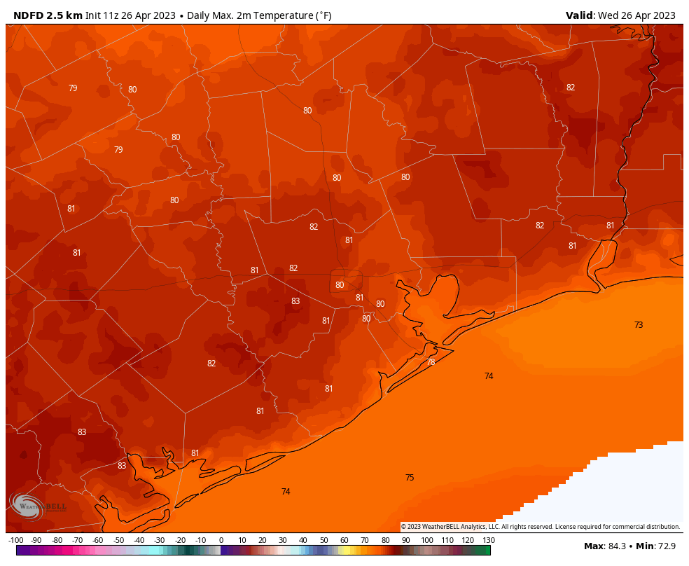
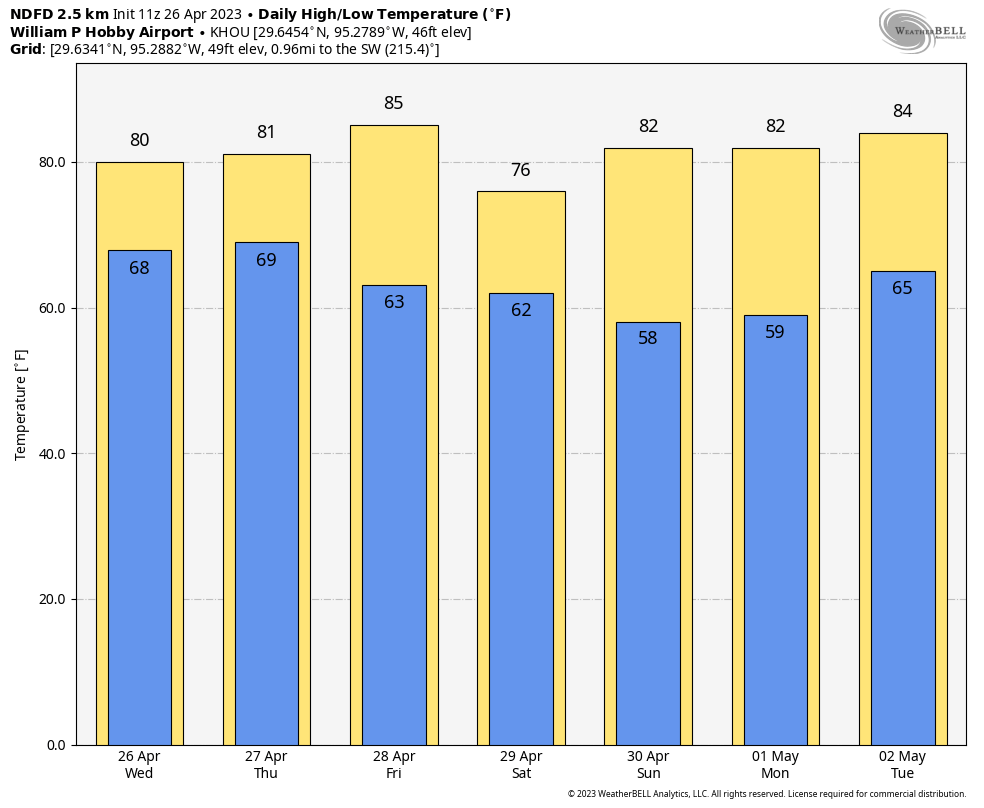
Today will bring mostly cloudy skies, with temperatures warming to about 80 degrees, and fairly muggy air. A very few, isolated light showers are possible today but overall I would peg rain chances at about 10 percent. This rather sedate weather should begin to change overnight, as a cold front approaches our region.
The timing of all this remains a bit uncertain, but around 2 to 4 am on Thursday morning a line of storms should move into the area of College Station and then progress through the Houston area in the time frame of 4 to 8 am, and push off the coast by around 10 am-ish. The best chances for rainfall will be along and north of Interstate 10, but I think the entire metro area has a shot at receiving heavy rainfall. Overall accumulations will likely range from 0.25 to 1.5 inch of rain, and there is enough instability to produce hail and damaging winds. So we’re definitely looking at the potential for some late-night mischief in Houston.
Thursday
Obviously, depending on timing, the above conditions may impact the morning commute. You’ll want to check weather conditions before venturing out early on Thursday. After the front moves through, skies should clear during the afternoon hours, with temperatures reaching about 80 degrees. Lows will drop to around 60 degrees on Thursday night with mostly clear skies.
Friday
The onshore flow returns pretty quickly on Friday, so this will be a warm and somewhat humid day, with highs in the mid-80s. Skies will be mostly sunny. Lows on Friday night will drop into the mid-60s ahead of our next chance for storms.
Saturday
Well, the weekend forecast is unfortunately not all that clear as the models have diverged pretty hard on the the evolution of cold front and an associated upper level low pressure system. The bottom line is that This area of disturbed weather will approach our region on Friday night. After that? The GFS model pushes things through fairly quickly, and largely ends rain chances on Saturday morning. The European model, however, shows the upper level low getting hung up, keeping on and off rain chances going into Sunday morning.
The most likely outcome is a more fast-moving system, I believe, such that rains end on Saturday morning some time, with mostly cloudy skies and highs in the upper 70s on Saturday afternoon with northerly winds gusting up to about 25 mph. But we now have to account for the possibility of shower activity lingering on Saturday and Saturday night, a probability I would put at about 30 percent. Lows on Saturday night will also depend on how fast the aforementioned upper level low and front move, so right now I’ll ballpark them in the upper 50s.
Sunday and beyond
Regardless of what happens on Saturday, we should see clearing skies on Sunday, and drier air. Look for highs in the upper 70s and another cool night before a warming trend early next week. We can probably expect highs in the mid-80s for most of next week, with the return of some clouds and pretty decent humidity by mid-week.


Was there any possibility of tiny hail this morning? Asking because I’ve heard some reports on the South part of BW-8
“ Overall accumulations will likely range from 0.25 to 1.5 inch of rain, and there is enough instability to produce hail and damaging winds. So we’re definitely looking at the potential for some late-night mischief in Houston.….” – Spacecity Weather
I hope this helps
Hi Eric! We live in Friendswood have a water party planned for Saturday afternoon. Do you think it would be wise at this point to push it to Sunday? I obviously dont want the kids to be too cold..
Thanks
Best to keep checking forecast next few days prior to your event to make that decision
Any chance we could get an MS 150 forecast update for Houston to La Grange Saturday and La Grange to College Station Sunday? About 5000+ riders are currently stressing over the unknown.
Can I get a Ween concert forecast?