In brief: Severe thunderstorms are developing in Houston as of noon on Friday, and will pose a threat for the next 12 hours across the region. We’ve got details about all of the threats in this update, with a particular concern for the evening commute.
As anticipated, with daytime heating, we are seeing severe thunderstorms developing in the Houston region. As of 12:30 pm CT there are large clusters of storms near Kingwood and just west of Katy. From this point forward we expect additional development throughout the afternoon and evening hours as the capping inversion over the region breaks.
From now until about 5 pm the majority of activity should be clustered along and north of Interstate 10, but that certainly does not preclude thunderstorms developing in the southern half of the region. Unfortunately we expect that the majority of the region is likely to see activity during the evening commute as the storms spread, making for a messy time on freeways. If you can leave earlier today, that’s probably for the best.
In terms of threats we have three major concerns right now.
RAIN: These storms will be capable of producing heavy rainfall, and under high rainfall rates we are likely to see street flooding. For this reason we have implemented a Stage 1 flood alert for the region through tonight. Essentially, you need to be weather aware on roads, take extra time, and do not drive into high water. Rainfall amounts will vary widely, with most of the area likely picking up 0.5 to 2 inches. I am concerned about a few bullseyes of 4 inches or more, which are possible.
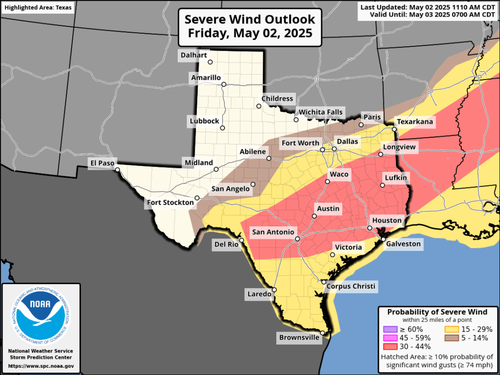
WIND: There is a healthy chance of damaging winds with these storms, so anything you can batten down would be helpful. The threat of damaging winds is the highest we have seen so far this spring, so again this is another reason to stay off roads amid strong thunderstorms this afternoon and evening if possible.
HAIL: In some thunderstorms near Kingwood weather spotters have already observed quarter-sized hail this afternoon. So this is a distinct threat as well as these storms pass through.
Tornadoes are also possible, but the threat is on the lower end of the scale.
Over the next several hours the bulk of the storms will shift southward, ahead of a front rumbling into the area. Areas south of Interstate 10, accordingly, will likely face the greatest threat of severe weather from late this afternoon to late this evening. By midnight, or shortly afterward, the threat of storms should move offshore. After that, the weekend looks lovely.
We will update later today as warranted.

Idk y’all… I just washed my truck to tempt the rain gods. My section of The Woodlands completely whiffed last night, and things look to be building to the east of me. Hope y’all are right i’d like to not run my sprinklers for a while.
Thanks for your doing your part!
Will this be a “nothing – Berger” like so many others? It seems to be trending that way.
Very odd – been watching NWS Radar site … it shows (history motion radar) we’ve been drenched in the last hour or so (Magnolia).
Nope, not a drop. Now 2.40pm and still shows rain around us, but zero.
We did get rain last night about 8.30pm, and showed more to arrive about 11pm, but it dissipated.
MSN weather states, “rain starting in 38 minutes” … we shall see.
You can have some ours in Kingwood. As usual, we’re taking the brunt of this crap.
Thank you for the update, Eric 🙂
Pardon me for feeling doubtful about all of this. Feels more and more like rainstorms just disintegrate into nothing as they pass over Houston
Theres been a capping inversion around Houston thats keeping rain away, but starting this evening that will chage as a cool front will push storms south thru the city to the coast
Okay, I’ll have to look up capping inversion, that’s a new term for me. As I’m looking at the rain accumulation map there’s a big ring around Houston showing basically no rain here :/
Yes, earlier today on the radar there was rain and severe weather to the west, north and east of me but nothing south. The cap was clearly visible over Houston and to the south. It’s eroding now but there doesn’t appear to be anything severe imminent. Hopefully just some good beneficial rain. Given the choice between a cap and severe weather, I’ll take the cap every time.
Water, water everywhere,
But not a drop in Houston
lol it’s so annoying I know! But that front has taken all afternoon to get from Kingwood to the city. Take a look at the sky right now before it rains harder. The clouds are blowing from the SW. The wind from the SW at cloud height is warm which is impeding precip. Like Tina said when the front gets here that will change.
Finally, the rain to west of us has moved over to the east into Copperfield and we are getting a nice steady gentle rain!