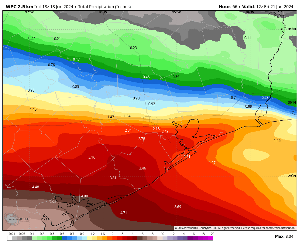
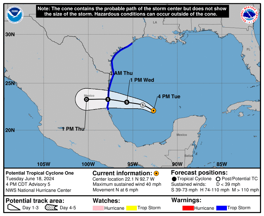
In brief: We’re starting to see a few bands of showers move into the Houston region from a ‘potential’ tropical storm in the Southern Gulf of Mexico. However, as we have observed over the last day or two, the threat of sustained heavy rainfall and flooding in the Houston area continues to decrease. We’re still watching things closely over the next 24 hours, but we don’t anticipate major problems in the metro area.

Airports and severe weather
Let us begin this post with question: My wife is flying into Bush Intercontinental Airport on Wednesday shortly after noon. Do you think her flight will be canceled with the storms?
It turns out this is a trick question! The wife in question is actually my wife. She really is flying into Houston tomorrow. Matt and I frequently receive questions regarding air travel and inclement weather, and I totally get the anxiety. However, neither of us are aviation meteorologists nor pilots. Unfortunately, we don’t have any special expertise or insight into the decision-making at airports that lead to flight stoppages, nor the cancellation of flights. We try to be helpful, but we’re never going to be able to give you the certainty on this issue that readers want. So I’ll give you the same answer I gave my wife: Probably not. Maybe. But probably not.
Before jumping into the post, I want to take care of a couple of housekeeping notes. If you’re wondering how to find us via email, our free app, or social media channels, please find all of those details here. Secondly, while this tropical system is increasingly unlikely to have serious weather consequences for the Houston area, that is not necessarily the case for southern Texas and Mexico. For more information about those sites, please check out The Eyewall. And finally, please find a brief message from our sponsor, Reliant, at the end of this post. Their support helps keep us online, and free for all.
Tuesday evening and Tuesday night
I anticipate that we’ll continue to see on-and-off showers and thunderstorms across the Houston metro area through this evening and during the overnight hours. Based on current model trends and radar activity, some of these showers may be briefly heavy, but we’re not seeing the kind of training storms that will lead to significant or widespread flooding. Some coastal areas may pick up 1 to 3 inches this afternoon and tonight, but most of us will see less than this.
Wednesday
Some time on Wednesday morning, possibly during the pre-dawn hours, more organized storms should move into the Houston area from the coast. Traveling from east to west, some of these showers may bring bursts of intense rainfall, and there could be some street flooding. This is a potential issue for the morning commute, especially for locations along and south of Interstate 10. Due to this potential for street flooding, we are maintaining a Stage 1 flood alert for the Houston region.
By Wednesday afternoon I think shower activity will start to become a bit more sporadic, but the potential for tropical rainfall will remain in place through the evening hours.

Rest of the week
We’ll transition to a pattern of more scattered showers on Thursday and Friday. Rain chances aren’t going to go away, but I also don’t think we’re going to be at any great risk of flooding. The gusty winds we’re experiencing today should persist into Thursday morning, by which time the “potential tropical cyclone” should move into Mexico.
Needless to say, we’re watching the evolution of these storms closely, and if there’s a change in our thinking we’ll post promptly.
A message from Reliant
Thanks to Eric and Matt for keeping us informed during this week’s tropical system and potential impact. We want to remind readers that Reliant stands ready to support Texans and help prepare. Here are a few things to keep in mind as we move through storm season:
- Reliant’s Storm Preparedness Checklist is a good place to start when thinking through what you need in place, like an emergency kit, go bag and communications plan with loved ones.
- Be prepared in case of an electricity outage. Your utility company (like CenterPoint in the Houston area or AEP for Corpus Christi) maintains the power lines, utility poles and electricity infrastructure necessary to deliver the power you purchase from Reliant to your home. Contact your utility company to report an outage or check the status of the repair.
- Check out more preparedness tips and recovery resources at ReliantStormCenter.com. The site provides resources for before, during and after a storm, including preparedness checklists and evacuation routes, weather and power outage updates, flood maps, safety tips and more.
Just like the summer heat, storms are a part of life in Texas, so being prepared is critical. Reliant is proud to power Space City Weather and help bring this important resource to Houstonians and our neighbors.

Thank you, SCW!
Thank you!!!!
What about the second system in the Gulf heading in the same direction as our current disturbance??
At this point it doesn’t look like a major issue for the greater Houston area. We’ll continue to monitor, of course.
Do you think it will basically follow the same path as the current one?
As of right now some sources are saying that the wind shear over that area by then should be greater than it is now and the chances of the second system developing don’t look as good. We’ll see.
Thanks Reliant for sponsoring SCW!
What about the second system ?? Any thoughts on it?in the Gulf heading in the same direction as our current disturbance
Second this. There’s another system coming right behind this one next week.
I suppose I can hate Houston slightly less for now.
Lol, you’re funny, Adam! I really enjoy you!
Channel 13 is still holding on to the 6-10 inch forcast over Matagorda and most of Brazoria Couny Lmao. SCW is called no hype for a reason 👍
Guess all in all, this was a “nothing Berger” for the Metro Area!!😂😂😂
hehe
Thank you for taking the time to keep us informed. I’m grateful that you guys are a dependable resource that we can trust!
Some TV people are using the word “cyclone”. Please explain how this word differs from storm and why it is being used. I thought it was for storms in the Pacific.
a cyclone is just air that rotates around a center of low pressure, occurring in the northern hemisphere.
It rained for five minutes out here in Magnolia. Right now, the sun beeming brightly. No cause for concern. (as I’ve mentioned in the last 2-3 days)
Good work guys!
I am reminding myself of the importance of stepping back and keeping my cool. There are likely to be many more such weather events this season.
Did anyone in Houston have a storm today? I line north of I10. We had a short sprinkle before noon. That’s it.
You’ve been saying the rain bands are coming in all day, & yet there’s been barely anything that touched HoUsToN besides a few scattered pocket…
And to think I held off on watering plants and the lawn
Exactly what I predicted two days ago… zero. We might see a sprinkle around midnight.
You did!
When I saw all the dry air filtering down I knew our rain chances would go to near zero. Not sure why the forecasters didn’t see this. On radar one could see the rain bands eroding away as they hit the dry air. Couldn’t see the forest for the trees I suppose.
I’m seeing the same thing. That deep plume of moisture is apparently not in place. All that rain out in the gulf that’s heading slowly this way seems for the most part to be drying up as it hits land. That could change, I suppose, but I may not even get one inch of rain out of it.
I’m a big fan of SCW and The Eye Wall, recommending the sites to others across the country, but what a blown forecast. Don’t get me wrong, I don’t wish floods on anyone, but my goodness…how far off can one get? “Record breaking precipitable waters” Efficient rains”. In reality its bone dry out here. Cool and pleasant. Our skies look like a winters day. Above 950mb the air is a desert right now.
Before you guys moan about what I write this sight puts its product on full display for all to see and comment on. I am commenting.
What, meteorologically, is going on?
Looking at the radar, spotted something weird. What’s with the donut-looking band of rain that appeared on the radar between 8:30pm and 9:30pm around Jackson, Mississippi?
These are usually birds or bats leaving their nest. Shows up on radar as an expanding ring. We get these here in Houston when the red-wing blackbirds take flight around sunrise-sunset.
I don’t get these comments. The rain is coming Tues night and Wed. That was always the case. Why are people acting like the storm has already passed and we got no rain? It’s not done yet.
Hi @Liz … well, it’s 6:04am Wed, and no storm yet here in Magnolia. And no doubt, if we do get rain, it’ll be a drizzle. Let us know when the “storm” arrives 🙂
Hey Liz,
Forecast had been predicting “heavy rain and flash flooding” for the greater Houston area ( not the areas closer to the storm track) for the past few days. Thankfully this hasn’t happened but we have to ask why. How could the forecast be so wrong? This affects all kinds of scheduling for airlines, trucking companies and so on. Most of us saw days ago the rain in this area would be slim to none but the weather product folks kept hanging on to the biblical floods.