In brief: Houston faces the threat of heavy rainfall, and possibly severe storms, on Thursday afternoon and evening. Beginning shortly after noon we’ll see stronger storms building north of Interstate 10. Eventually a (probably weaker) system will migrate toward the coast late this evening. Some additional rain is possible Friday before a prolonged period of hotter and sunnier weather.
The big picture
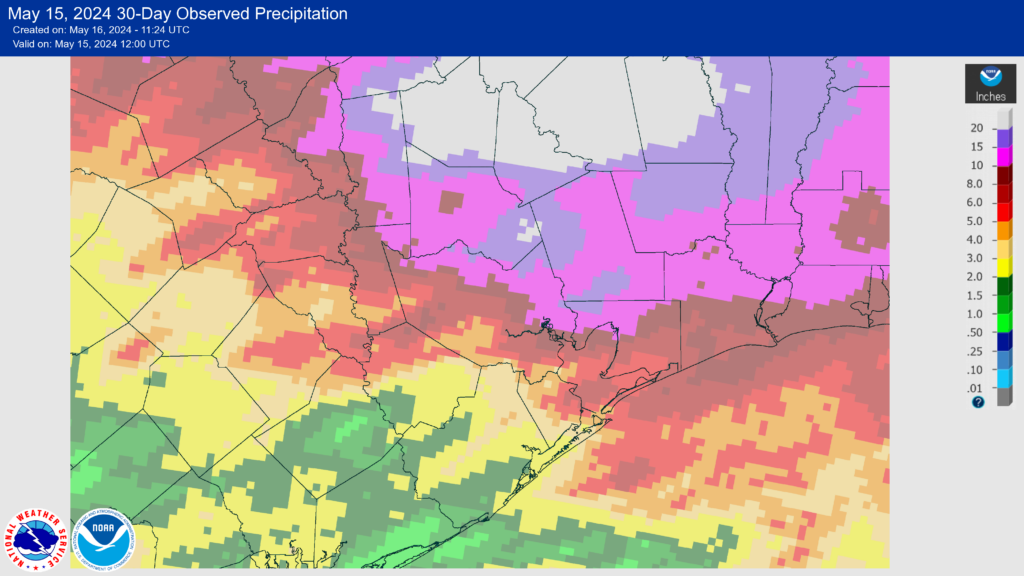
It may feel like déjà vu to be staring down yet another threat for storms and heavy rainfall, as it has been a truly wet spring for the Houston region. During the last 30 days, the majority of our area north of Interstate 10 has received at least 10 inches of rain, and locations further north, particularly in the Huntsville and Lake Livingston areas, have received in excess of 20 inches. This has led to significant river flooding, and we’re likely to see more of that in the coming days after storms this evening and overnight.
If you’re tired of it all, I don’t blame you. But I would also note, with some caution, that we’re about to experience a significant pattern change. High pressure will settle in, and after Friday the remainder of May looks very dry. Maybe not completely dry, but quite possibly so. This could set us up for another scorching June, not dissimilar to last year. So while significant flood relief is coming, we may begin to miss some rain in a few weeks. We’ll see.
Thursday
I’m not concerned about conditions on Thursday morning, which should bring cloudy skies and temperatures in the low-80s. However, beginning later this afternoon, perhaps around 1 to 3 pm, we’re likely to see the development of showers and thunderstorms to the north of Houston, in areas such as College Station and Huntsville. Conditions are ripe for heavy rainfall, as an upper-level system brings lift into an atmosphere filled with moisture.
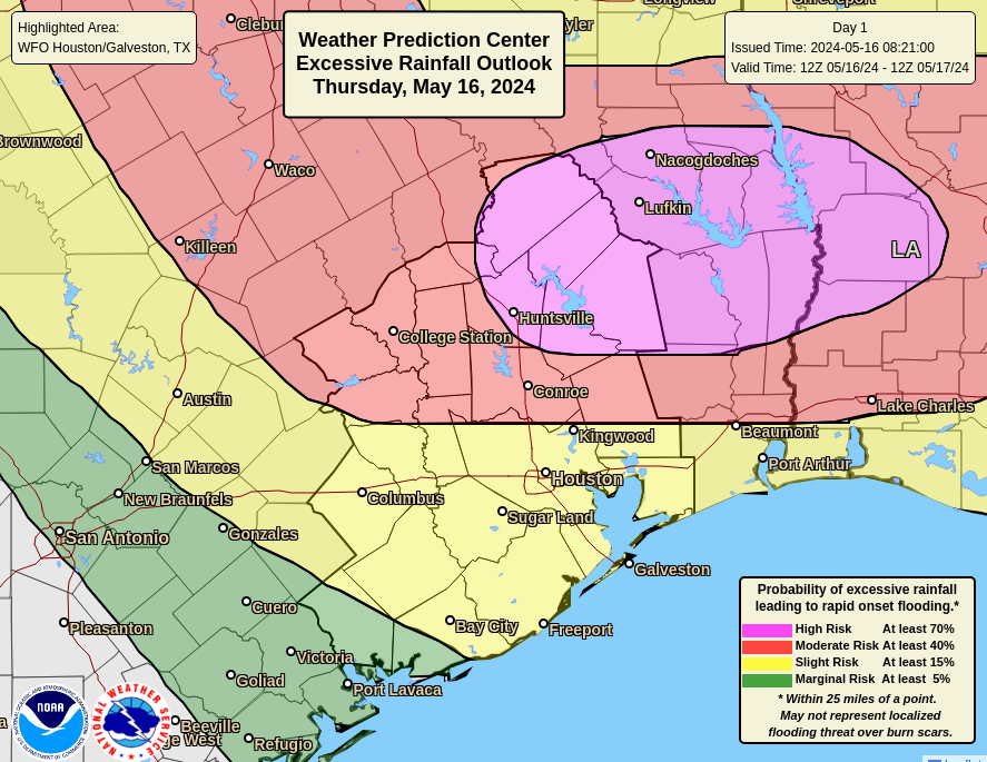
Some of these storms may well be severe. There is enough instability to support the threat of damaging winds and possibly a few tornadoes. (Hail, at this point, looks like a lesser threat). However, my biggest concern lies with the potential for heavy rainfall. Most areas north of Interstate 10 are likely to see 1 to 4 inches, but with these kinds of storms bullseyes of 6 or more inches are possible this afternoon and evening. By or before midnight, the worst should be over for inland areas. Long-term, we’ll need to monitor ongoing flooding of the Trinity, San Jacinto, and Brazos river basins.
After battering inland areas, the system is likely to migrate southward later this evening, and push closer to the coast near midnight. Heavy rain remains possible south of Interstate 10, but the overall threat is less.

Friday
An additional, final round of showers and thunderstorms is possible on Friday morning. This activity should be clustered closer to the coast, where the boundary will get hung up. Expect highs in the mid-80s, with possibly some partially clearing skies by Friday afternoon or evening. Lows on Friday night will drop to around 70 degrees.
Saturday and Sunday
The weekend looks sunny. I’d expect highs to slot somewhere into the low-90s on both days, with nights in the low 70s. Southerly winds look light, so plan your outdoor activities with confidence (and sunscreen).
Next week
More sunshine is on the way. Generally we should see mostly sunny afternoons next week, with highs likely pushing into the low 90s for areas of Houston closer to the coast. Inland areas may get a few degrees warmer. It won’t be full-on summer, but it will be rather warm. Rain chances are not zero, but they’re close for most if not all of next week.

It seems like every summer we settle into a High pressure ridge that keeps up hot and dry, usually lasting at least a few weeks, though sometimes can be several months as was the case last year, which was a seemingly normal year till May… then 4 months later we had water restrictions. My gut feeling, as a certified weather nerd, is it will be a rather normal Houston summer with a few hot dry spells, but nothing like last year. I also suspect we’ll get quite a bit of tropical rain this year based on the expected high activity.
Glenn has an over/under of 12 100F days. I’m taking the over. The SW ridge is coming. 500 mb up to 6000 meters. Memorial Day looks like a scorcher and it won’t take long to bake the water out. I love the rain. For me, the sunny blues are a gut punch after the last 4 years of dry.
Is it possible that this front will stall and/or come back up and dump more rain than expected in our area causing major damaging flooding?
Houston daily weather: hot, humid, rainy, and disgusting. Severe weather warning. Day after day. Get me out of this city already. I am so happy this is my last summer here.
Were you too busy complaining to realize that the weather was none of the above from November – April?
We too are happy, adiaos.
buh-bye, cya, enjoy having to shovel your driveway in the freezing temps.
It is So lame when people can’t resist being jerky. Even Here Even Grown Adults who probably think they’re upstanding Texans. Not just you whoever you are Mueschke but honestly. People can express dislike and Don’t deserve cowardly Baby responses. Be better. Do better. Some of us just wanna behave like sane non a hole adults. Be part of that crowd instead.
Agreed
I really miss snow and look forward to seeing it again.
Same. Love Texas, can’t take the murderous humid weather, year round allergies and 2nd worst pollution in the country anymore. According to a newly released Smart Survey report, the Houston area only had 38 good air quality days in 2023. Asthma is killing me. Taking kiddos up north to save them some of that and yes, I’ll get used to snow and 3 actual other beautiful seasons. Don’t blame Texas, but I do blame the leasdership. Texans deserve so much better.
It would have been great if all the recent rains could have been dispersed throughout May and June. We seem to have gotten into a “boom and bust” cycle of rain: all at once then none for a long time.
If we’re going to be hot and humid, we may as well as have daily cloudy afternoons with light short showers. Evens things out and keeps the temps in the low 90s.
To Jack and Mr.Jangle.
Im hoping you’re right. Im thinking the same way. We’re having a wet spring so far. That usually means the summer that we hope to experience. My examples that come to mind are 2002, 2003,2007, and most recently 2021. The Canadian long lead precip and the Euro models show above normal participation patterns especially for July through September. Whether that comes through tropical mischief or not we’ll have to find out on that one. It suggests the lack of the feared ‘death ridge’ torturing us for months on end.
Stay tuned.
I think the thing is, the rain has all been from temperate low pressure systems, which have stayed too far north for areas southwest of Houston to get much rain. Those areas have been on the northern end of high pressure south of us, which has been keeping that area dry. I think it was the same way last June. I fear that as this high moves north as summer approaches we will see absolutely no rain.
The issue is why in the world there is so little rain south of here. It is as if the high pressure systems are getting stronger, and suppressing rain more fully than they used to. How come we used to get the random sea breeze thunderstorms without any real low pressure system that might cause flooding, whereas the past two years, or arguably the past four years, we either have a strong high with absolutely no rain, or a low with flooding storms?
Please tell me I am wrong: Does global warming cause high pressure systems and capping inversions to get stronger?
Some forecasters are calling for increased rain chances next week (tue-wed) due to a frontal boundary. Can you speak to those risks?
So, any forecast for how many times my power will go off and on tonight? Last front was five times in 90 minutes. (Thanks, Centerpoint.)
Just glad we finally get good weather on the weekend and rain during the week instead of the other way around.
Other than the flooding, which was really bad a bit further north, I am happy to see consistent chances of rain right now as much warmer weather is ahead and we need the rain when we can get it. This helps the rivers, creeks, and reservoirs as well (I know flooding is not a good thing in these areas) and will help ward off drought conditions.
Tired of rain! What rain? The most rain we’ve had at one time this month was almost an inch! I’ve lived down here just south of Dickenson for 40 years. It always seems to rain more in Dickenson and then increases the further north you go. Therefore, I’d rather the rain continue in our area.
Why is there no SCW flood scale alert?
I love this website.
Great weather forecasting and the Comment section never disappoints for hilarious entertainment.
User name works for me!
Ugh. Houston weather is so extra. Nothing in moderation! Deluges of rain… followed by scorching drought. :-/
I am forced to agree.