In brief: The Houston region will see one final round of showers and potentially severe weather today, but only the southern half of our area is at risk. After this morning, the bulk of the heavy rains and thunderstorms will shift east. We then can look forward to a pleasant, sunny weekend.
Storm status
After some central and northern portions of the Houston metro saw storms on Tuesday and Tuesday night, it is now the turn of coastal counties to see widespread activity. An atmospheric disturbance is propagating up the coast, and it will drive showers and thunderstorms in our area, primarily south of Interstate 10, with the greatest activity for locations right along the coast. Although the likelihood of severe weather is lower than Tuesday, we cannot rule out the possibility of a tornado.
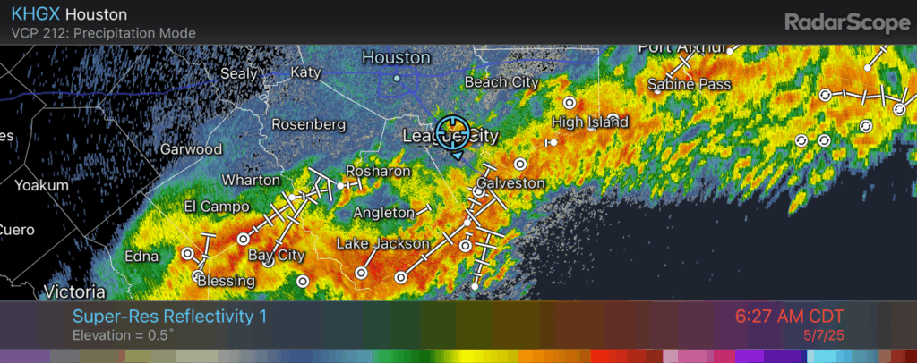
Rain accumulations may briefly flood some streets, so we are maintaining a Stage 1 flood alert in place for areas south of I-10. (Most areas north of I-10 will see limited to no rainfall today and tonight). Areas right along the coast may pick up 1 to 4 inches of rainfall, with lesser totals further inland. By mid- to late-morning the bulk of this system should have moved off to the east, clearing the region, and ending the possibility of widespread showers and thunderstorms.
Wednesday
As noted above, your weather this morning will depend a great deal on how far you live from the coast. However most of the region should see clearing skies this afternoon, and this will allow high temperatures to jump into the low- to mid-80s for most locations. Winds will generally be light, from the east. Lows tonight will drop only to around 70 degrees.
Thursday
This should be a mostly sunny day, with temperatures reaching the mid- to upper-80s. There will be a slight chance of afternoon showers and thunderstorms, perhaps 20 percent. Temperatures on Thursday night will drop into the upper 60s.
Friday, Saturday, and Sunday
A weak front will slowly drag some drier air into the Houston region, and this will lead to some nicer days as we approach the weekend. I’m not sure whether this will be the final front of the season to make a meaningful impact on temperatures and humidity, but it may well be. Anyway, we should see three mostly sunny days, with highs ranging from the upper 70s to lower 80s, with moderately drier air (dewpoints in the 50s, probably). Nighttime temperatures will likely drop to about 60 degrees for a few mornings, with some inland areas hitting the upper 50s. Again, this is not cold by any measure, but it is far cooler than the weather that lies ahead of us for the next four to five months. Finally, we cannot entirely rule out some rain chances, but they’ll be quite low each day.
Next week
As high pressure builds in most of next week looks hot and sunny. By Thursday or Friday we could start to see daily highs in the vicinity of 90 degrees, with plenty of humidity. Summer will be on our doorstep.

Posted this on the other article but don’t know if anyone would be reading those comments anymore
For those wondering, a lot of why the storms never really materialized in the metro area was due to lack of instability. A very large MCS (squall line) to the north of us shielded us from surface heating which underperformed by a bit, farther to the west there was plenty of CAPE (4000-5000 J/Kg) which is why a lot of the storms out west went severe. Lapse rates also underperformed by a bit. Although I do agree it was a forecast bust, spring time weather is very unpredictable and meteorologists such as Eric and Matt are doing their best. The problems at NWS and NOAA certainly don’t help either.
Thanks for all you do over there at SCW!
(Also feel free to correct me if you believe I’m wrong)
Hey, Weather Enthusiast …
I was watching Mike I. on fox26news this early am. He did make a somewhat negative comment during the forecast about the models being off. I tried to find the recording (it was after 7am), but they don’t save all the weather recordings. He showed a “model in motion”, where it showed no storm activity. That’s when he rolled his eyes and made his opinion about the model errors.
However, I did find the 5:18am forecast recorded video, and Mike said,
“the models are not doing a very good job on this”.
At 5.18am, the storms were still working their way from Corpus to Galveston area.
I’d agree, models always have their discrepancies but we are always lucky to have them, I remember around 2 days before all the snowfall around here occurred all the models besides NBM (the national blend of models) downtrended a ton on snowfall amounts to almost nothing, although yes that may have been because snow + Houston = confusion there have been plenty of other overperformances and underperformances (ex the day where there was supposed to be almost no severe weather but instability overperformed thanks to the GoM and there were 2 tornadoes in the Houston area)
Unfortunately there are people who don’t trust weather forecasts on this site even if your post has some valid info to explain what occurred yesterday. They expect perfect predictions throughout the year
Agreed, whine everytime. Great job Eric/Matt! 😊
It doesn’t always rain in SE Texas, but when it does, it does so during rush hour.
I’m happy when threats of severe thunderstorms and tornadoes fail to materialize. Although, for those who don’t follow weather forecasts closely, there is a possibility that those folks won’t believe the next forecast of severe weather, to their own detriment.
Same
For this part of the country the temps in May the past two weekends are great.
1/4″ of rain near the west belt is what we got from all the storms over the past several days. I put more water on the garden from my sprinklers than we ever get from the skies.
Dr. Ryan Maue has a program that evaluates the models skill scores and for whatever reason the GFS accuracy have dropped off drastically. Some speculate that it may be due to the DOGE cuts. But it is clearly performing poorly.
Some observations: Matt and Eric do a super job given the challenges of putting together a forecast with modelling data that doesn’t seem to be performing as well at times lately. Don’t know if it’s climate change, job cuts at NOAA and the NWS or whatever. Also, it is challenging to put out a general daily forecast that covers an entire viewing area (TV meteorologists) or an entire region. There could be two or more different weather conditions within that region. What ends up being a bust in one part of the region may not be a bust in another part of the region. Last night I noticed a few sources (Ventusky and TWC) had backed off on rain and severe weather for this morning in my specific area. Even KTRK lowered the rain chance to 40%. The other sources still had my area getting severe thunderstorms. Sure enough, this morning all I got was sprinkles and distant thunder. Technically a bust generally west and north but not a bust south and east.
I hope you’re right about the weather being nice this weekend because several other weather services are predicting 80% chance of rain Saturday
I would check your location figuration, although there may still be a cutoff low hanging around east TX and Louisiana I don’t think an 80% chance of rain and storms are justified by models currently. I’d expect a 15-25% chance (depending how far east you are). Rain is a possibility but not very likely
NOAA no longer has the data points it needs to piece together the forecast models, & yesterday showed the degradation of what the cuts are doing to the models.
The most recent Eyewall has a link to a document called Passback & its cuts to NOAA. It was a brutal read. It discussed how the services NOAA has been performing will be absorbed in the Department of Homeland Security. Free to read online.
Further, the DOD published a paper in 1996 for the ‘USAF 2025’, entitled ‘Weather as a Force Multiplier, Owning the Weather in 2025’. If what it says it true, then it might explain a lot about what’s going on with NOAA now. Free to read online.
Matt & Eric are trying to cobble together an accurate picture from decimated data. They can’t possibly know the extent of my gratitude for their efforts. Their experience and dedication will make a distinct difference in the health & lives of all of us, especially going into hurricane season.
Everybody loves a scapegoat. “Forecast became inaccurate after Jan. 20, 2025”
Agree. This isn’t new. I read the USAF paper and it reads like something from the 1950s. Utter nonsense from a weather forecasting point of view. May be useful on the battlefield but that day has gone the way of tank warfare. Drones are now.
I’ve scoured the internet since Dan started braying about this subject a few weeks back and the only losses I can read about are a few balloon radiosondes in various locations. It isn’t holes in the models and the initialization data. Its lack of follow-up reporting to see what’s changing – the deterministic models take hours to run. And folks have other jobs. One could look out the window and make an update. Some AI updates would be good – these run on desktop.
We missed the derecho and Beryl last year. This year we went the other way. So it’s not new. A once or twice daily update from NWS is not going to cut it in the springtime here. Very soon we’ll enter the summer doldrums and there won’t be much to do but complain about heat and humidity. A good time to tune.
PS I am glad it was a pleasant couple of days with only light rain. Would not have liked to redo the home repairs needed last year.
If it was 1950s scifi material, then the UN wouldn’t have standing agreements against ENMODS since the 1970s.
Tip of iceberg.
In March Matt said he was concerned with the level of error going up in concordance with the strength of a bad weather event. 90% of the time it won’t be so noticed, but the 10% will.
He also said it increases the risk profile & and “repeated increased loss of real-world observational data will lead to very significant degradation in weather model performance”.
There are holes in the weather balloon radiosonde data, the data that make up the models, the models which we have depended on to guide us towards best decisions.
Especially with hurricanes.
Yeah, it’s just a bunch of overdramatic people whining and spreading the medias fear mongering propaganda because the people they don’t like got elected. The cuts have not affected weather forecasting much at all, if any. Weather forecasting has always been hit or miss, and most of the time, a miss. Nothing has really changed.