In brief: Houston may see some short-lived thunderstorms this morning ahead of a front. But the real weather story is likely to be gusty, very dry winds that will increase the potential for wildfires this afternoon and evening. Please take care with open fires. After that we have a mostly spring-like, mostly pleasant week ahead of us.
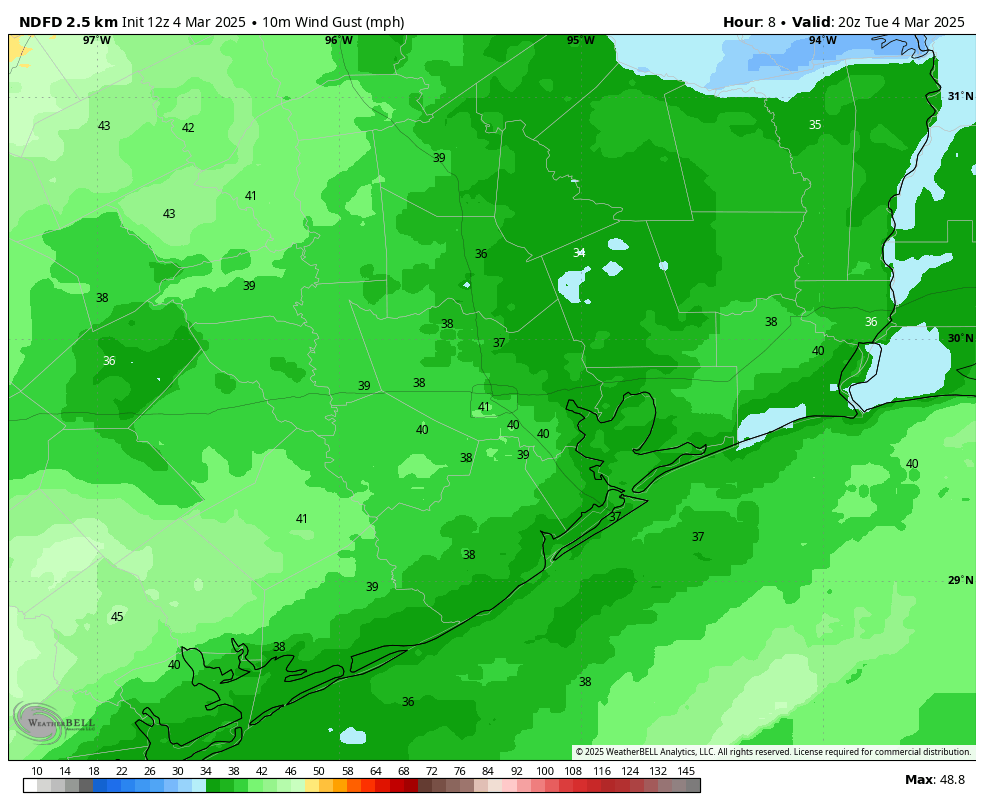
Red Flag warning
Nearly all of the metro area, save for areas east of Baytown, are under what is known as a “Red Flag” warning today after 10 am CT. This indicates the potential for fire danger due to strong winds and very low humidity. By late morning we will see westerly winds sustained to about 25 mph, and gusts up to 40 mph or potentially higher along with a front that is moving in. During this time you should avoid open flames and take care with cigarettes. Winds should begin to slacken this evening.
Tuesday
Houston faces the potential for one, or possibly two, thin lines of storms this morning ahead of a cool front. Although these storms are unlikely to be severe within the metro area of Houston, we cannot rule out some briefly strong thunderstorms. (The odds of severe weather are greater to the northeast of Houston, in locations such as Livingston). The last of these storms should clear the area by or before noon, with most locations picking up a few tenths of an inch of rain. Temperatures ahead of the front will be in the 70s for the most part with plenty of humidity. However, this humidity will sharply drop after the front, hence the Red Flag warning.

Rodeo forecast
The Houston Livestock Show and Rodeo kicks into high gear today, with the first concert of the season in Reba McEntire. This is a forecast you’ll want to pay attention to, because although you won’t have to worry about storms, winds will peak during the mid- to late- afternoon hours above 20 mph, with gusts of 40 mph or higher possible. These winds will have died down somewhat after the show is over. Temperatures will be about 70 degrees heading into the show, falling to the lower 60s by the end of the concert. Lows will fall into the low 50s by Wednesday morning in Houston.
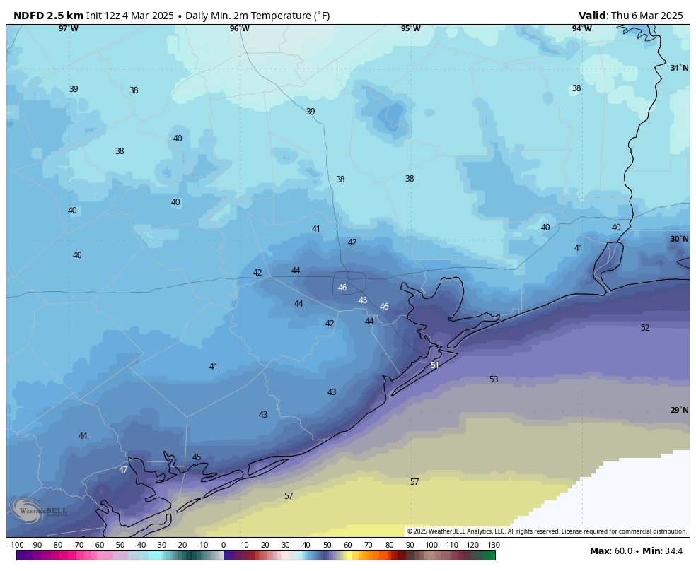
Wednesday and Thursday
These will be a pair of sunny, calm days with highs in the mid- to upper-60s. Wednesday night into Thursday morning will be the coldest one of the week, with lows dropping into the mid-40s in Houston, and cooler for inland areas. Thursday night will be several degrees warmer as a southerly flow returns.
Friday
This day should bring cloudy skies back into the forecast, and highs approaching 80 degrees. There will be plenty of humidity as well. Lows on Friday night will fall to around 60 degrees.
Saturday and Sunday
A cold front will arrive on Saturday, perhaps during the morning hours. Most of our guidance indicates this front will be dry, but at this point we cannot rule out the possibility of a few showers and thunderstorms. Saturday afternoon likely will see clearing skies, highs in the 70s, and breezy northerly winds. Overnight lows drop into the 40s in Houston.
Sunday looks sunny and very pleasant, with highs in the mid- to upper 60s. Expect another night in the 40s, probably.
Next week
We’ll be fairly warm next week, with highs likely pushing into the lower 80s. It should be some of our warmest weather of the year so far. Overall rain chances look fairly slight for much of the week.

With no rain after today for the next 10 days, it looks like the drought will return.
The drought will very likely return, and this summer will probably trump the 2011 and 2023 summer in terms of heat
Why in the world would it be hazy after the storms? Shouldn’t the storms clear out the gunky stuff?
I didn’t see anything about hazy skies mentioned in this post but I may have missed it.
It’s probably the dust from out west way up aloft. It looks like it used to look back home in north Texas when a big dust storm was on its way. My weather station says the humidit is 10% down here on the coast.
Man the rain on my roof up here in the woodlands right now sure sounds like a lot more than a few tenths of rain
Send some of that my way please.
Are you going to address the government firings at NOAA? I do remember the concern from one of you if this happened. It’s happened and nothing from you. Because you were told not to make any comments? If that’s the case, that’s a frightening issue in itself.
They did address it a few weeks ago on their February 9th post I believe.
There’s not always a conspiracy, although they do seem popular these days.
Well, it’s 9.30am now in Magnolia. The temp has dropped about 20°F within minutes – it’s almost 50°F now. Front just moved thru.
It’s been rainy since before 7am, and the winds have been about 30-40mph for about 20 minutes, with a (2nd) blast of showers, basically raining sideways because of the high winds.
We also lost power twice – first lost it when the high winds began. Fortunately, power is back on. And just now, the winds and rain have simmered down.
Surprised to see red flag warnings given how much rain I’ve had lately (almost 3″ one day), but it must have just been our part of town.