Good morning. As we get closer to the weekend our forecast is coming into slightly better focus, but we still have some questions about the timing and intensity of some storms that may roll through on Friday, and potentially again on Sunday. Let’s jump in.
Thursday
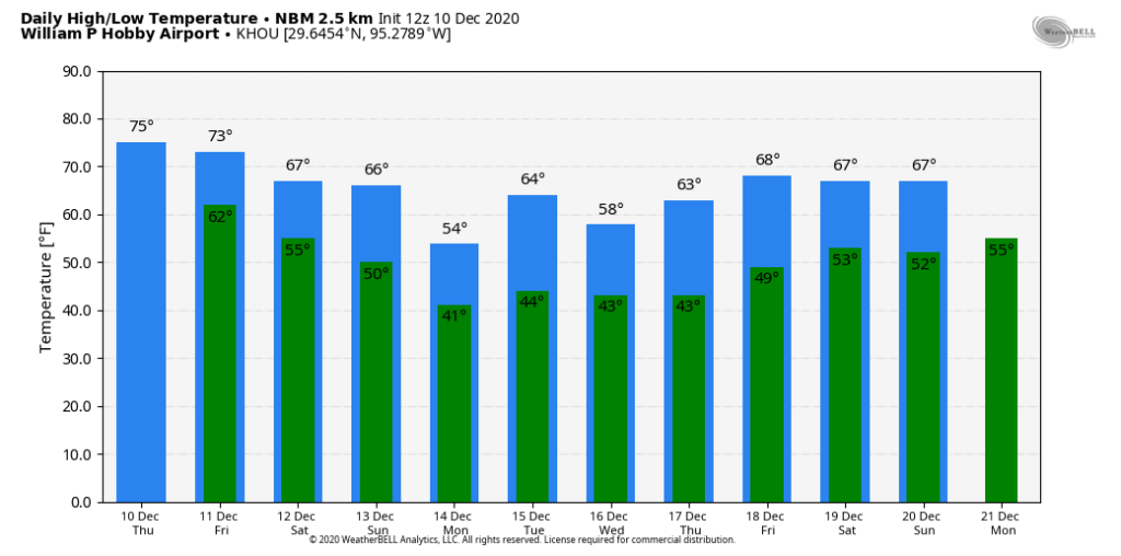
The big change for today will be winds, which will become more pronounced from the south during the daytime. Even though moisture levels will increase some, I still think our skies will remain mostly sunny. This will allow temperatures to climb into the upper 70s. Southerly winds will continue overnight, pumping more moisture into the area. Lows likely will not fall below 60 for most of the area.
Friday
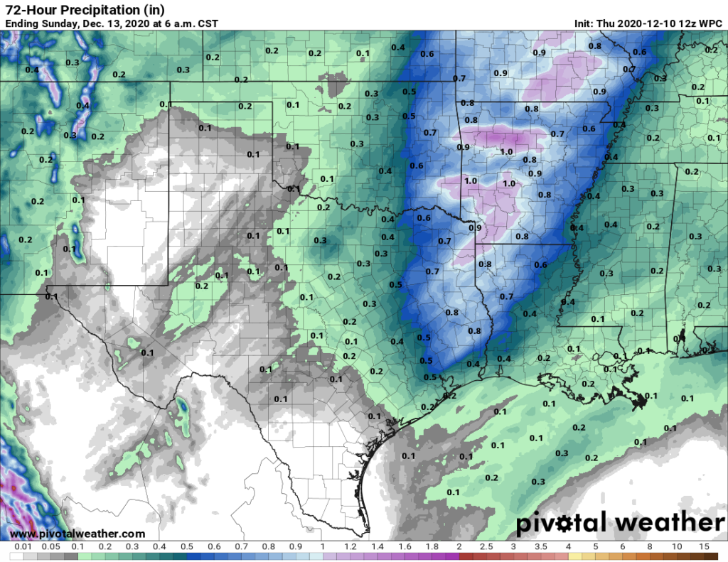
An upper-level system will approach Houston on Friday, and combine with this moisture to produce widespread showers and perhaps a few severe thunderstorms. The primary threat will come from strong wind gusts. I think the afternoon hours will be the most likely period for rainfall, and expect most of the region to see 0.25 to 0.75 inches through Friday evening. Rains should end by Friday night as a cool front nears the area.

Saturday
This front should reach Houston during the morning hours, and move off the coast by or before noon. At this point it looks like Saturday will turn out to be a rather nice day, with highs perhaps reaching near 70 degrees, and plenty of sunshine during the afternoon to go along with light northerly winds. Lows Saturday night will likely drop to around 50 degrees in the city.
Sunday
Another upper level feature will approach Houston on Sunday, and this could drive another round of rain chances during the daytime. The global models are not in great agreement on rain totals with this second system, but for now I’d expect less rain than the region will see on Friday. Matt will have to get the scoop for you in tomorrow’s post. Highs Sunday will likely get into the 60s, with partly sunny skies. A stronger push of cold, dry air arrives later Sunday, or Sunday night, setting the stage for cooler conditions.

Next week
I expect the cooler and drier weather—highs in the 50s and 60s, lows perhaps around 40 degrees—to hang around for much of next week, with a warming trend only kicking in perhaps by next Thursday or Friday. Winter is coming (back)!

Thoughts on Xmas week? Really hoping it’s not 75-80 degrees again this year!
We need it to be 80 degrees on Christmas, because you can’t gather indoors. The warm weather is exactly what we need. Hopefully this winter will, as predicted, be drier and warmer than average. Hopefully we won’t see any real freeze this winter.
Yeah I hope it will be a warm 80 degree day for Xmas!! Some rain is okay too as long as it remains warm and humid!!
I appreciate the weather. I attempted to contribute to the “fund” but could not make a contribution. Some way or another, my computer would not “send”. I want to contribute
Yeah that 79 degree sunny day was really nice Wednesday!! But today is even nicer now that a little bit of humidity is back!! I’m looking forward to a warm night tonight and I think I’ll very much like Friday’s weather!!
December has been a bit chilly this year so that brief warmup is much appreciated!! At least there hasn’t been a major cold snap. Even with the cooler temps, I still consider Houston winters to be moderate!
I have a very specific question per tomorrow’s rain:
I am hosting an event that has excellent northern protection but not southern protection. Is it possible to predict if the rain will be blowing in from the north or south or some other cardinal direction? Or is that just too specific? Thanks!