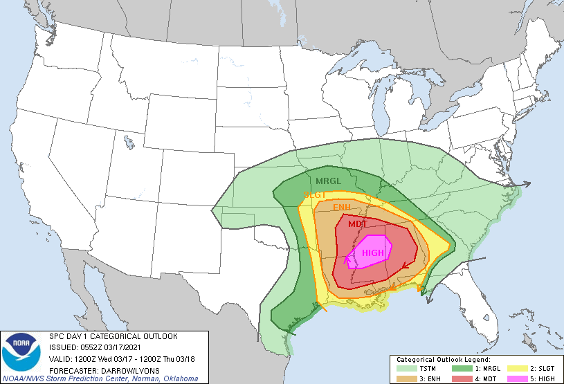
Good morning. Today will see a line of thunderstorms move through the Houston area between 7 am and Noon, to be followed by an influx of drier air across the region. This storm system will find more favorable conditions east of Houston, and there is a large area of the southern United States where severe storms—including tornadoes and hail—could form later today. NOAA hasn’t issued a “high” risk warning for severe storms, which is the magenta-colored area centered over Mississippi in the map below, since 2019. This is a serious situation, and any travel east of the greater Houston area today should be carefully considered.

Wednesday
As of around sunrise, a fairly organized line of storms is moving through the College Station area, and this will continue to advance toward Houston this morning. However, due to a capping inversion, we expect the intensity of these storms to weaken as they move into the city. They should exit to the east by around Noon or 1pm. Rainfall accumulation for most will be around 0.25 inch, which is unfortunate because many areas could use a little more than this. We cannot rule out an isolated strong thunderstorm, so take care when out and about this morning in Houston.
Glorious spring time weather eventually awaits us behind the front, and we should see clearing skies this afternoon as drier air moves into the area. Lows tonight will drop down to around 50 degrees, and winds may gust as high as 30mph out of the north.

Thursday and Friday
Thursday will start out gusty as well, but winds should die down some during the afternoon and evening hours. We’ll see sunny skies throughout the end of the work week, with highs in the upper 60s to 70 degrees, and lows in the upper 40s for the most part. It looks like Friday night will be the coldest night of the week.
Saturday and Sunday
Saturday will see full sunshine and highs of around 70 degrees, but as winds take on a more southerly flavor we may see a few clouds start to pop up by Sunday, when highs may climb into the low- to mid-70s. Rain chances remain near zero throughout the weekend.

Next week
We’ll see a continued warming trend into the early part of next week, as highs get into the upper 70s perhaps, with slightly better rain chances and more clouds. It looks like some kind of front will work its way through on Tuesday or Wednesday, but I don’t have any confidence in the details.
So for now, enjoy our amazing spring-like weather in the days ahead, and check on friends and family members in the southeast after the storms there later today and tonight.
I got 1.2” this morning in the Heights.
Woohoo!
I look forward to your posts everyday and forward them to friends and family!
Thank you🙏🏻