In brief: A line of storms passing into Houston will clear the area later this morning, and the region should see clearing skies for the second half of the day. Then we’ll have a brief period, about 24 hours, of somewhat drier and cooler air. A second front (no strong storms this time, probably) may bring some similarly cool weather for the weekend, but no promises.
Election Day weather
You don’t need me to tell you that today is Election Day in the United States. We are seeing storms pushing through the metro area this morning, but they will be east of the area by or before noon. After this there will be mostly fine conditions this afternoon, with clearing skies and light winds as a weak front settles in. Space City Weather is apolitical, but that does not mean we don’t encourage everyone to vote. Please find the time to do so today. The weather will be fine.
And then, after the election is over, I would hope that we remember that we are all Americans, stronger when united than divided. Just because your neighbor put out a Trump-Vance sign, or someone down the street has a Harris-Walz bumper sticker, does not mean they’re a bad person. We’ve been too conditioned by heated rhetoric and social media to ‘hate’ those who have different political opinions. If you actually get out and talk to your neighbors, no matter their political views, you’ll find that in Houston we’re all united behind common values, such as: summertime humidity here is the worst.
Tuesday
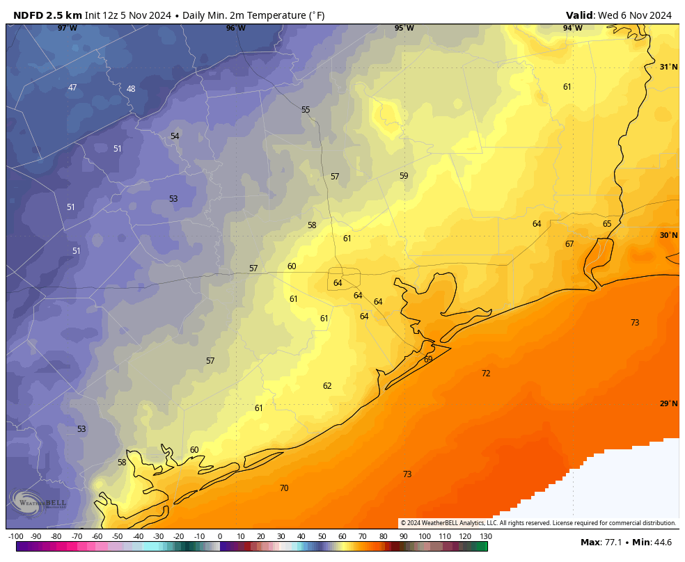
I expect the line of storms rumbling into Houston this morning to reach the coast by late this morning, and move offshore. Modestly drier air will move in behind the front today with northerly winds at about 10 mph. We should see clearing skies this afternoon with temperatures in the lower 70s for the most part. I expect it to be quite lovely this evening. Overnight lows in Houston will drop into the upper 50s for most locations, with coastal areas remaining in the 60s. For a day or so, it’s going to feel like fall.

Wednesday
By tomorrow we’ll start to see the beginnings of an onshore flow, and dewpoints will recover pretty quickly. So don’t blink or you’ll miss the drier air. Skies will be partly cloudy, with highs of around 80 degrees. Lows on Wednesday night will not drop below 70 degrees for most of Houston with muggier air.
Thursday and Friday
These will be a pair of partly sunny days with high temperatures in the low 80s, and warmish nights with lows around 70 degrees. There will be some low-end rain chances each day, but any accumulations will be slight.
Saturday and Sunday
Another front will approach the region ahead of the weekend, but the forecast models are still pretty divided on how much cooler or drier air it brings. In other words, I’m afraid our forecast for the weekend remains pretty low confidence. If pressed, I’ll say daily highs will be in the upper 70s, with nights in the 60s, but I’m prepared to be wrong. Rain chances aren’t zero, but they’re also not very high, maybe 20 percent daily. We had a question from the Houston Marathon about long training runs for this weekend, and at this point I wouldn’t be overly concerned about rain chances on Saturday morning. Whether we get some drier air in time for a long run remains possible, but not a certainty.
Next week
Even if we do get some decent cooling with this weekend’s front, we should be back into a warmer and more humid pattern early next week. Most of our guidance still indicates the arrival of a nice cold front during the middle of next week, but I’m still not confident enough to make any promises. However, it does seem fairly likely.

Tropics
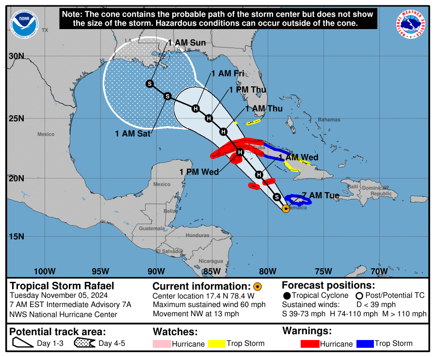
Tropical Storm Rafael is strengthening this morning, and should cross Cuba into the Gulf of Mexico by later on Wednesday, likely as a hurricane. The storm’s current forecast track may look concerning, but the reality is that there are two scenarios which are most likely—and neither is particularly threatening to Texas.
The first scenario is that Rafael remains a hurricane as it reaches the central Gulf of Mexico, in which case it is likely to be steered toward southeastern Louisiana or thereabouts. If Rafael becomes weaker it is more likely to drift due westward toward Texas. However, in this scenario the storm would be considerably weaker, and probably not pose much of a threat beyond some easterly winds and higher seas. We’ll continue to watch things closely, of course. Look for a full report on The Eyewall later today.

Yep! Houston summertime humidity is the worst!
I vote for fall in Houston to actually feel like fall… not summer jr.
I did a write-in vote for fall when I went to the polls. 🙂
fall/winter 2024
oh man it is ugly out there. luckily i got to work right before the downpour.
good luck out there houstonians
Thank you for your comments regarding valuing our neighbors for our similarities, rather than our potential political differences. “Storms rolling through the area” should apply only to our weather, not to our rhetoric.
Thank you for your message reminding us that we are all better when we are united! So true!
Yesterday’s official low of 78 is higher than the average high temperature for the date. Also the warmest November minimum temperature for Houston ever, I believe.
When in doubt stick to the weather! Since this is Houston, there’s usually a lot to talk about.
The one good thing about the extra humidity is that it is helping us get these needed downpours.
Beautifully spoken! I truly see concerns for both parties. I prayed and voted for who I thought would be the best leader. My continued prayer is that we come together and fix the wrongs on both sides.
Thank you for your very positive comments on the election.
As an Apolitical I cannot agree more with your comments about division, we need to stay united!!
No matter what happens.
I hope some cooler weather comes through soon though & that Hurricane stays away in the Gulf.
Still planning on doing a winter outlook post or did I miss it?
The odds are favoring a warmer and drier than normal winter largely due to La Nina which is expected to fully emerge by January. This doesn’t mean that we won’t have any cold and rainy days, it just means that we will see less cold and rainy days than usual because of a steady northern jet stream position. we have already seen that this fall. However, I tend to trust seasonal forecasts about as much as a coin toss.
might as well just say the weather will be disgusting the rest of the year into next year.
Since you raised the subject; wouldn’t it be perfect if people voted for the candidate who most closely matches their own standards of moral and ethical decency.
Life is not perfect Ken, whatever the outcome is, better to be united than divided
Yes–in the primaries.
“If you actually get out and talk to your neighbors, no matter their political views, you’ll find that in Houston we’re all united behind common values, such as: summertime humidity here is the worst.”
I’m just here to say that I’m not just here for the weather, even though it’s the best. I thoroughly enjoy your writing and the people you are in print. Your realistic perspective and humor are routinely the highlight of my news feed. Thank you for what you do and for doing it so well.
I’m ready for fall…These warm humid days, especially mornings, have me feeling bitchy at times…
Are we sure drier air is coming in? Just took my dog for a walk and while temps are down, I could definitely still feel the humidity. Looking at the forecast, it’s not predicted to go below 70%. I don’t really consider that dry air.
The dew points dropped into the low 60s and upper 50s this afternoon after the front passed through. That is not exactly run to get the skin lotion dry air, but the water vapor content is significantly lower. Even though the humidity is still rather high it still feels more comfortable than it would if the dewpoints were in the 70s like earlier this morning.
I really appreciate all of your posts about our weather. Today, I respect you for your comments about after the election. Our Rabbi also speaks about not hating or getting into fights with others for their political views.