In brief: Our confidence is increasing in the likelihood of heavy rain across the Houston metro area on Thursday morning, perhaps around sunrise or a few hours later. Flash flooding is possible in the strongest storms.
The overall forecast from the post we published this morning remains more or less on track. However, our confidence is now very high in impactful storms pushing into, and through, the entire Houston region on Thursday morning. Although we still have some questions about timing and placement, it is clear that a serious line of storms will go through.
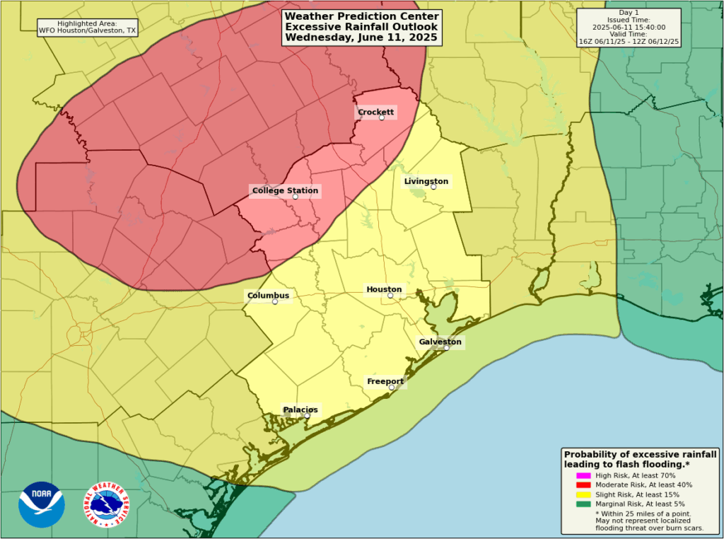
Tomorrow morning, before dawn, there may be some isolated or scattered showers and thunderstorms across the western half of the Houston metro area. However, the main event is likely to be a line of storms that forms northwest of the region and sweeps into the city. In terms of timing, we think this mass of storms will impact areas such as College Station around 5 am to 8 am, before pushing into central parts of the region (including the area inside Beltway-8/Sam Houston Tollway) between 8 am and noon. After this the line will likely continue down to the coast and exit the area to the east.
The models disagree on where the most impactful rains will be: Brazos County, Montgomery County, or Western Harris County are all possibilities, for example. But the bottom line is that we are going to mix a potent disturbance with an atmosphere with a lot of moisture. This is fertile environment for high rainfall rates, which can quickly back up streets and lead to flash flooding.
As a result of this we are elevating our flood alert to Stage 2 for areas along and west of Interstate 45.

Although we cannot entirely rule out other forms of severe weather, flooding is the main threat from these storms. Most of the region will likely pick up 1 to 4 inches of rain in a couple of hours, but there will almost certainly be higher bullseyes where 5 to 8 inches could fall in a very short period of time. In short, be prepared for disruptions to travel plans on Thursday morning, and be weather aware. We will have a full update for you early tomorrow morning.

“A wet June makes a dry September” – weather lore
I will take that trade off considering our history of storms in September.
That is not always the case. June of 2002 was wet and September of 2002 was very wet for our region. June of 2018 was wet, and September 2018 was extremely wet.
I just planted a new bed of vincas, mulched..This rain is displacing the mulch onto the sidewalks, and I keep sweeping back into the proper place..Bleh..I hope these daily heavy rains don’t drown my new flowers..
They make a mulch adhesive that can help keep it in place. Called the dominator I believe.
I’d rather have daily rain than a drought when heading into peak summer.
Dang! I was afraid of this. I have a medical procedure scheduled for 11:30 am Thursday in the Med Center area. Now I don’t know if I should drive to that area before the rain starts or wait until it’s over. If I cancel the procedure, it could be several months before I can reschedule it.
I’d go early. You can always hang out but you don’t want to not be able to get there if it will take a long time to reschedule. Hope it all goes well.
Don S
okay, Now, drive to the Med center get yourself a hotel room, stay there overnight. go to vist in the morning. Now actually call ahead reserve a room, and then drive down, and get a room,
bye
Thoughts on late morning/early afternoon drive from Willis to Katy? I’m debating heading home to Katy tonight instead.
Was the Memorial Day flood 8” in a short time? Is this the magnitude event we’re talking about?
Sadly east, west, south of something means nothing to me. Wish they would say cities most impacted!!
To each their own, but I prefer this way. I dislike listening to the weather alerts on the radio where they list off every affected county, city, region, subdivision, neighborhood, and HOA and you have to wait 30 minutes just to hear if yours is the one the tornado is bearing down on.
I think a simple regional map is an indispensable tool for better understanding any forecast, whether it helps one to identify all the nearby counties, cities, etc or to identify general directions such as “north of I-10.”
They don’t know exactly which cities or areas will be most impacted, aside from the likelihood that areas towards the west of 45 may experience more rain or flooding than areas east. Picking out a city like Sealy or Hempstead would make people feel like they are in the clear if they live in Cypress for example. Modeling is not going to give you the answers you seek, so they need to speak more in generalizations. Just prepare for heavy rain this morning, because there’s a shot you may get it no matter where you live.