In brief: Everyone in Houston, whether you want to be or not, is a storm chaser this morning. The worst of Beryl should unfold over the next three to six hours, after which we will see improving conditions from south to north. This post describes what to expect during this period of most intense conditions from the storm.
A few thoughts on the arrival of Beryl
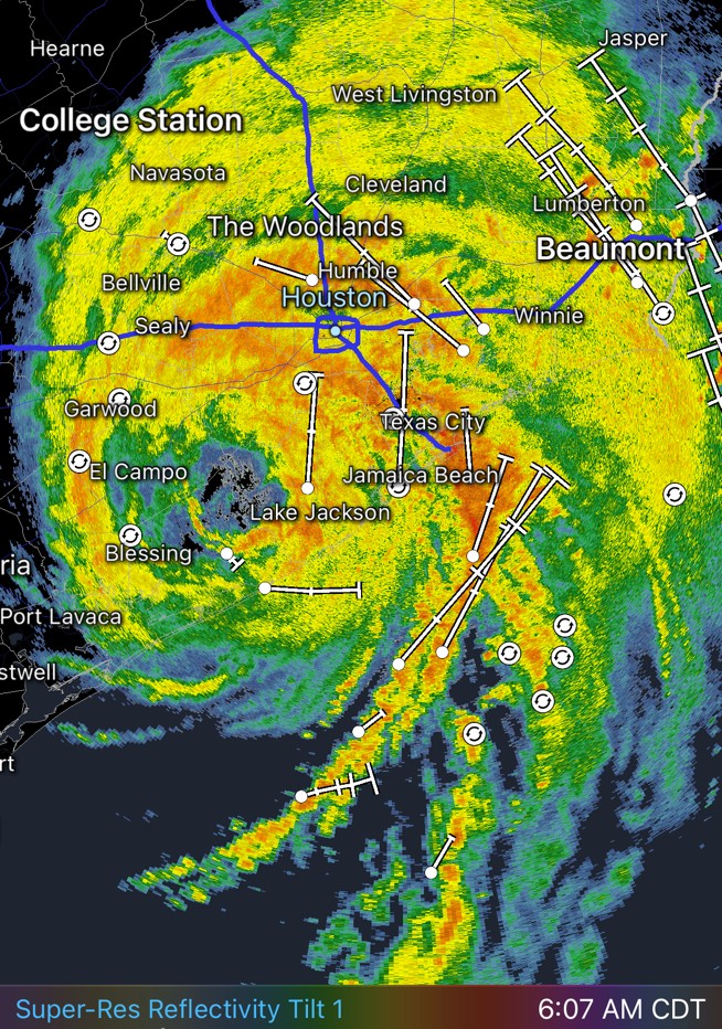
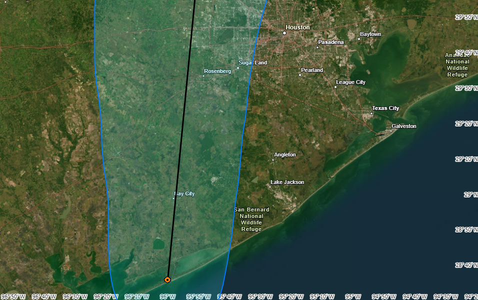
Good morning, everyone. Beryl is finally here—not that you need me to tell you that—and so far things are going about as expected. The storm is presently nearing Fort Bend County, and its center will pass through the western half of the city of Houston between now and about 11 am CT. The very worst of Beryl’s effects will be over by then for the city.
Let’s start with some good news. The storm is continuing to move just east of north at about 12 mph, which will allow it to clear the area by this afternoon. We are highly confident in that forward speed. Additionally, the storm did intensify some prior to landfall, but it came ashore as a low-end Category 1 hurricane, with 80-mph winds. Given that Beryl had more than two full days and nights over the Gulf of Mexico to intensify, and with water temperatures in the upper 80s and increasingly low shear conditions, I consider us to be fortunate that Beryl was that strength at landfall. It was starting to intensify, in earnest, as it came ashore. Another 12 to 24 hours and it’s likely a significantly more powerful hurricane.
That may be small comfort if you’re sitting at home this morning without electricity or have some property damage; or if you’re just feeling really miserable as the tempest engulfs you. But this could have been much worse had Beryl gotten to 90 or 100 mph prior to landfall. It’s ultimate track is going to bring the storm’s center and worst winds and rains over large parts of the Houston metro area. This is a very bad track for wind damage with a Category 2 or Category 3 hurricane.
What’s next for Beryl
As the storm encounters land it will start to weaken today. However the storm should remain at or near hurricane strength as it traverses the metro area this morning. The center will move through Fort Bend County, passing near Sugar Land, and up through the western half of Harris County. It will then push into Montgomery County by or before noon before exiting to our north early this afternoon. And then, it will be gone.
Beryl’s winds
Much of the Houston region is starting to see sustained winds above tropical storm force strength this morning, with gusts of 60 mph or higher. These winds should increase a little bit as they reach their peak levels across much of Houston over the next four hours. For areas north of the city, including Montgomery County, peak winds should come a little bit later, perhaps between 10 am and noon CT.
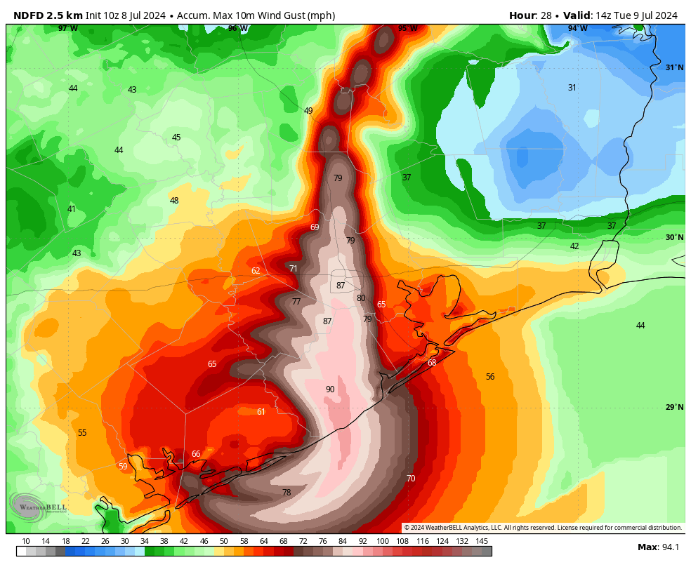
As the winds have increased this morning, the number of power outages in the metro area have steadily increased. As of 5:45 am CT, CenterPoint is up to 396,000 customers without power. Expect that number to increase as Beryl pushes inland. Efforts to restore power should begin as early as later this afternoon as the winds subside.
Heavy rainfall
The strongest band of showers and thunderstorms is now moving through the metro area, roughly along Interstate 45, from Galveston to League City, on into central Houston. These storms are dropping 2 to 3 inches of rain per hour and there are numerous reports of flooded streets. Based on radar trends, I anticipate these rains will slowly lift north with the storm over the next several hours.
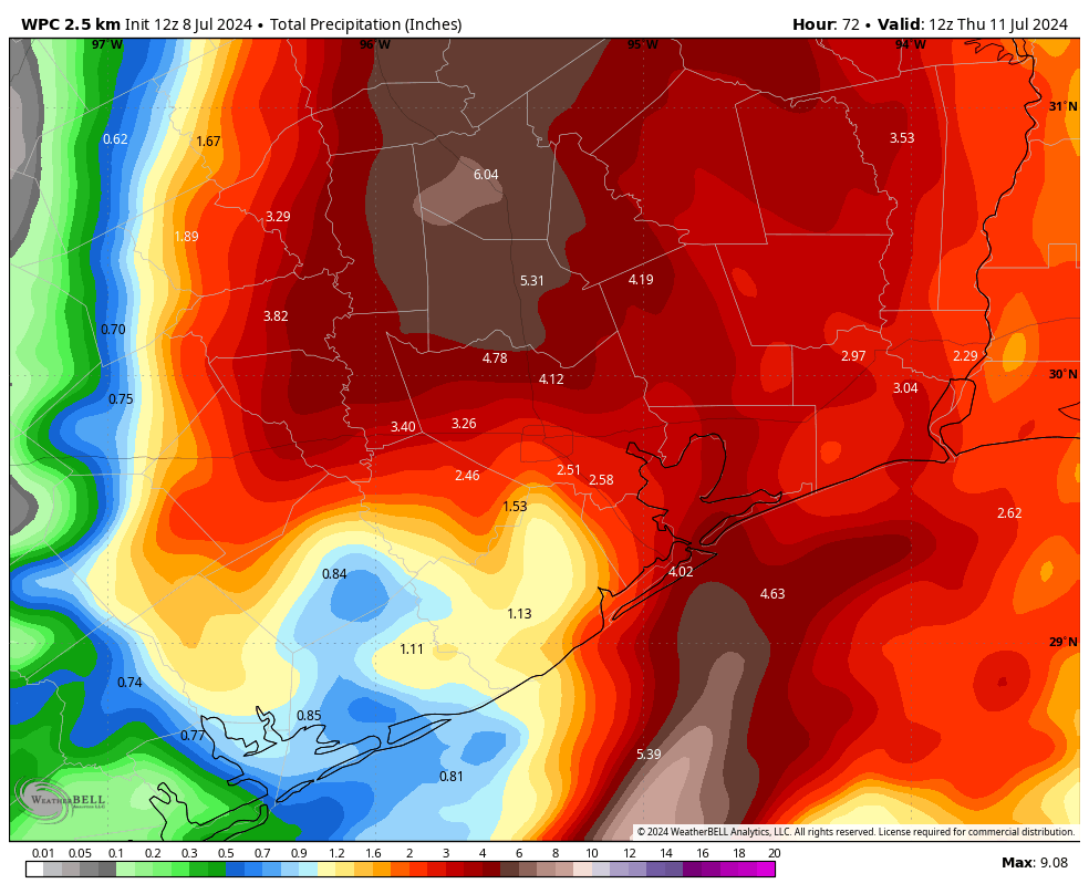
Expect the heaviest rainfall to end, from north to south, likely between the hours of 8 am and Noon CT. Additional showers will be possible thereafter, but the worst should be over. Expect accumulations of 4 to 8 inches for most locations, with the potential for some higher bullseyes.
Tornadoes
We’ve already had one tornado warning this morning for areas north of Houston (it has since ended) and we expect some sporadic twisters to spin up as Beryl’s core moves through the city. These will be fast moving tornadoes, and likely only touchdown for a short period of time. If you receive a warning on your mobile phone, please seek an interior room on the lowest level.
Coastal flooding
Storm surge flooding will peak over the next hour or two, with high tide coming in a few hours. These waters will rapidly recede this afternoon as Beryl pulls away.
Our advice this morning
The worst of Beryl is now upon us. Conditions may deteriorate a bit further this morning, before we start to see improvement in conditions by late morning hours. So hunker down for the next 4 to 6 hours, and then we can begin to assess the damage and move forward. If roads are passable (considering flood waters or downed trees) it should be safe to be out and about this afternoon, and especially this evening.
Our next update will come between 10 am and 11 am CT.

Thanks for everything you guys do!
Let me echo the thanks to the whole SCW team on this eventful morning!
Rain coming down here (not severely though) in Magnolia as expected (6:26am). No high winds yet. Looked out front of house – no sign of debris blowing around.
We obviously lost power for a while, because the clock on the microwave was flashing, asking to be set. Hopefully, if we lose power again, it’ll be short lived.
Any expectations for northern counties? Polk? Thanks y’all!
Just hunkering down with power out waiting for the winds to pass by. At least the clearing will be South to North so those if us here in the Greater Clear Lake Area will get relief sooner rather than later.
My mom is in Clearlake. How is the weather there now?
What do we think about Brays Bayou? Will it flood and lead to houses flooding? I.e. Meyerland area?
Go to the Harris County Flood Warning website and you can see rainfall rates, totals, and even stream elevations.
https://www.harriscountyfws.org/
Next level you can see forecast stream elevations on NOAA website. Bray’s Bayou:
https://water.noaa.gov/gauges/HBMT2
Lost Power Crosby, TX since 4:30am.
North side of Crosby here. Mine was lost at 6:30.
Neighbors across the street still have blue tarps on their roofs and yours truly is fighting with insurance from the tornados back in May. And now this bs. We have paid our dues. Hate to be that guy, but other parts of the country can take then next few. Sorry not sorry
Oregon definitely needs rain badley. Prayers for all of Texas.
Things mostly okay in west League City. Power’s flickered on and off multiple times, but it’s still on. Street has some water but isn’t flooded or anything. The wind is definitely making some noise, though!
Pretty rough in Sugar Land now, tree limbs down, electricity going on and off, winds gusting 50+. Overall, could be worse.
Downtown Humble has been without power since 6am. Heavy rain and wind is happening
Power out in Clear Lake by NASA. For about an hour it was very unstable but now staying off.
Great job. As always. Thanks.
Power’s out for us in Pearland as of aroud 5:30am. Generator is blessedly doing it’s thing! Best investment by far to not be trying to move around the house in the pitch dark with 2 Velcro pets who don’t much care for storms. Stay safe and thanks Eric and Matt for gently talking us through this one.
On the bright side we should not have to worry about a drought for the rest of the summer…
I wish that were true. It’ll be bone-dry in a couple of weeks….
Grateful to still have power for the time being. Raining pretty good here in the Heights and gusty winds now and again. But not complaining one bit. As you said, could have been a lot worse if a Cat 2/3+ had followed the same track. As always – thanks for all you do!!
Your weather reports are priceless. THANK YOU!
3rd Ward is seeing gusty winds and lots of rain. Rain is driving in from the East, North/East which is rare. The streets are draining. Tropical storm level winds. Don’t want to jinx it but we still have power.
Power out and major street flooding with water 3/4 of the way up yards.
I’m on the edge of Spring/The Woodlands and the power has been out since 6:30. I had high hopes it wouldn’t go out since it didn’t during the derecho but no such luck. I had just turned on Dark Side of the Moon about 10 minutes before, a great album to listen to as storms roll in. Anyway, thank you as always for keeping us informed and being straightforward about it all. You guys are a much appreciated calm amongst the sometimes chaos of Houston weather!
Thanks for this, haven’t heard from my family in the area so going to chalk it up to power outages.
You’re welcome! The power came back on for a while then went out again around 9:30. Cell service has been really spotty. A lot of my texts aren’t going through, but I just received 16 at once so maybe the towers are coming back up.
the Weather Bell rain map is hard to believe. The numbers nearest the 610 loop, south of I-10, are 2.46, 1.53, 2.51, and 2.58 inches remaining for this storm. Can they possibly be this low?
Tomball, NW of Houston, it’s darker like early morning and we are getting gusts with intermittent bursts of hard rain. So far, no flooding. We have power and water.
In Clear Lake and power flickered for a few mins then went out about 4:00ish. Winds have been the issue for us as there are a lot of limbs down. I’m hopeful we’ve sent (or will very soon) the last of the big gusts! Stay safe everyone!
These winds gusting to maybe hurricane force are impressive. I can only imagine a cat 5 hurricane with sustained winds of 150+ mph. I can’t even fathom that…
Remember the widespread power outages for the next storm. Don’t predict that only south of I-10 will have widespread outages. Now it’s a waiting game–how long before my power comes back on (here near Champions). Tomorrow? A week from now? Will anyone ever hold Centerpoint accountable for its pathetic management of the local grid? Why not bring some competition to power restoration–pay multiple companies to restore power, a certain dollar amount per customer restored. It would be like the tow trucks racing to the scene of an accident competing for the revenue. Centerpoint does not need a monopoly on power restoration and they should be penalized for the terrible job they’re doing around here.
In west Houston on hwy 6 just north of Bear Creek. Power went off at 6:00 am. Sitting here with coffee and my fan thanks to the generator. Good luck, all!
Wagoner’s opera The Flying Dutchman comes to mind this morning.
Thank you. I’ve recommend your forecast regularly. I appreciate the personable no hype content.
Eric,
Every single prediction I’ve seen, either here or in the models (except ICON) showed this as tracking far west of Houston. This feels and looks like a direct hit, right? Seems eye still tracking Northeast. Perhaps this is for the debriefing but what happened here that the models we rely on got it so wrong?
You’re reports are priceless~ no power here in Champions since before I woke up from the noise around 6AM. If this is a Category 1, I cannot imagine anything above that. Thanks for all you do.
I have a question. I went outside around 5am and the rain smelled like the ocean or salt water, so I wondered…How much of this rain is salty ocean water and does it have an affect on the plants and grass? I’ve never paid attention after a hurricane to see if plants are affected.
My water softener sometimes has issues and when I water indoor plants it has killed them almost immediately and left the white salt powder on the soil. That’s when we know the softener was having an issue allowing salt water into the faucets.
I noticed the same thing and also wondered.
Channel 13 has lost power. Streaming on Instagram Live.
We are in the eye. Completely calm. 14 Cowboy Way, Richmond Texas. 😎
Power had been out here in Montrose since around 4am. I feel like we didn’t even make it to the big event before we lost it lol. Made some good ol pour over coffee and feeling grateful that things weren’t worse. Matt and Eric, y’all are incredible. Thank you for all the hard work and thank your families for letting us have you in these times of need.
How can you have a hurricane without a single flash of lightning or thunder clap in Houston just west of 610?
Baytown has gotten hit hard. Constant rain and wind bands coming in over Bolivar and steady on us since 4-6 am. The gusts have been beyond crazy. Lots of damage. For us over here the big story is the wind. The eye of Ike went right over my house but this has been scarier.
Just changed my phone battery. Still waiting for the wind to die down to assess damage. It is nice that the temp has dropped since power is still out. Been more wind than rain.
How about Bush Intercontinental? We had our first option direct from EWR cancel. Now routing through Ft Myers and into IAH at 6:45.
The damage is bad in Sweeny. The power has been out since 2:30am and there is tree limbs everywhere. The neighbors across the street had a tree fall on their roof. My house was spared thankfully.