In brief: The overall forecast remains the same. We’ll see hot and sunny weather for a couple of more days. Saturday still should bring a decent shot of rain into the region, especially for areas closer to the coast. Then we’re back to sunny and warm until some sort of front arrives early next week, perhaps on Tuesday. A little fall weather would certainly not be unwelcome.
Wednesday and Thursday
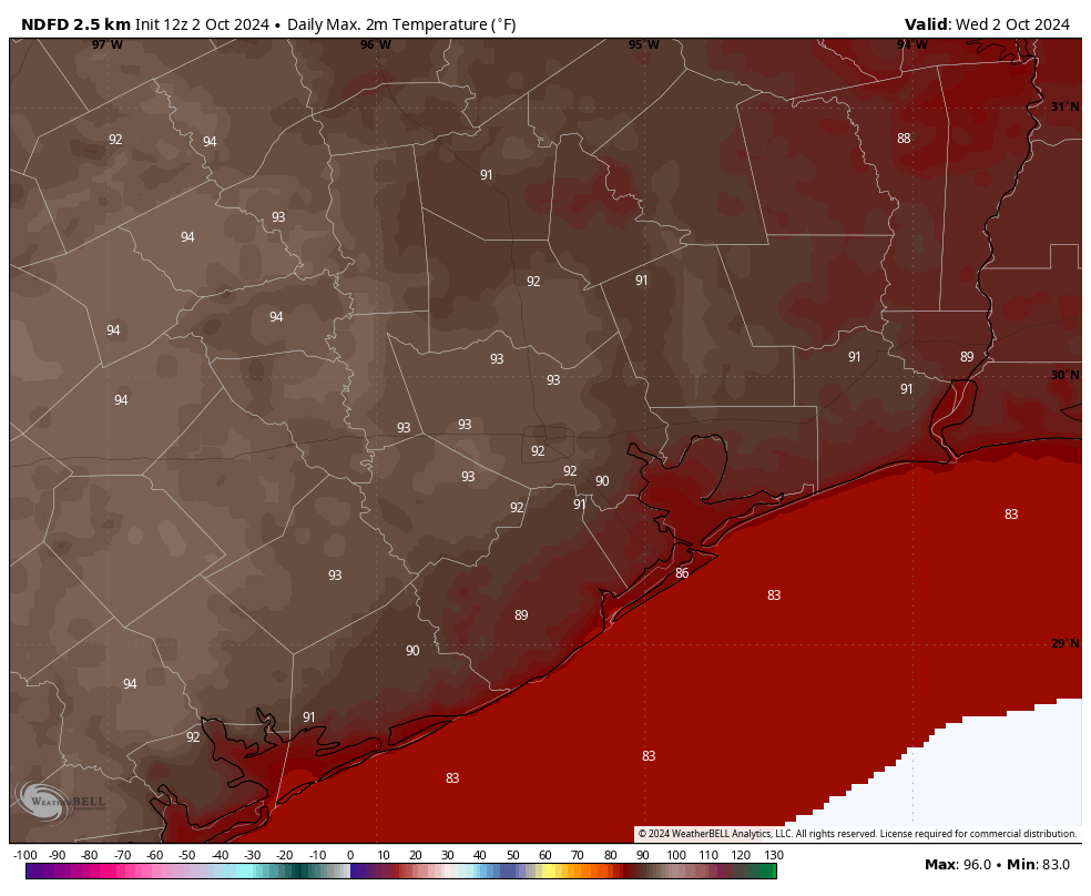
Clear skies and warm temperatures will continue for the next couple of days across the metro area. We’ll see nearly 100 percent sunny skies, with no chance of rain, through Thursday evening. High temperatures, for the most part, will be in the low 90s. Overnight lows will drop into the lower 70s for most locations not immediately along the coast. With dewpoints remaining in the 60s, the air will feel marginally drier than typical summertime conditions in Houston. Winds remain light, generally from the east at 5 to 10 mph.
Friday
We’ll start to see a few clouds by Friday as the upper-air pattern becomes more unsettled. However, skies will still be at least partly sunny, and rain chances are only likely on the order of 20 to 30 percent. For areas inland of Interstate 10, they’re even lower. High temperatures will reach about 90 degrees for most locations, or perhaps a touch warmer.
Saturday and Sunday
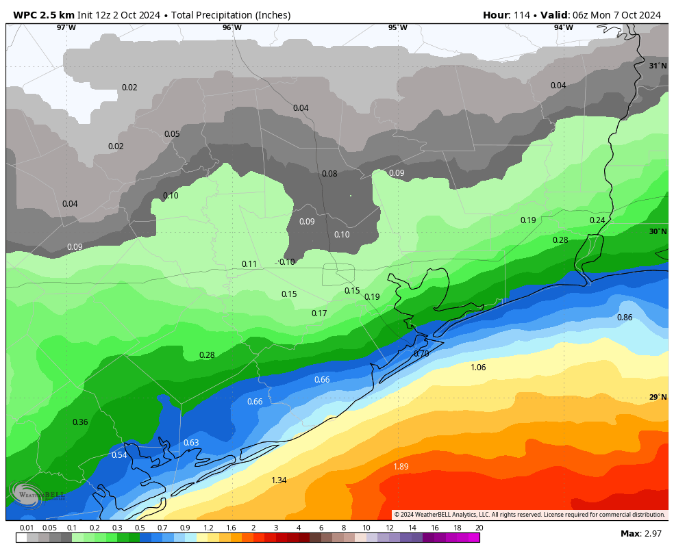
We should see more cloud cover for the first half of the weekend, as well as our best rain chances for the forecast period. Locations along and south of Interstate 10—closest to the source of moisture—will probably have about a 50 percent chance of showers during the daytime, with lesser chances further inland. I do not expect a deluge, but rather a series of scattered showers pushing through. Accumulations for most locations will likely be on the order of a few tenths of an inch of rain. Highs, due primarily to the clouds, should be in the upper 80s.
By Sunday we’ll be transitioning back to a more sunny pattern. However, I still expect to see at least some partly cloudy skies, with perhaps a 20 to 30 percent chance of rainfall. High temperatures will get back into the lower 90s.
Next week
Monday should bring more clear skies and high temperatures in the low 90s. However, at some point on Monday night or Tuesday, we should see the arrival of a front, with some drier and cooler air following it into the region. There’s still quite a bit uncertainty as to how much drier air will arrive, given that our region will be receiving a glancing blow from the front rather than a full on push out of the north. Nevertheless, I expect highs to at least drop into the 80s, with lows in the 60s. It’s possible we’ll get a bit cooler than this, but determining that six days out just isn’t possible with this kind of front.
Tropics
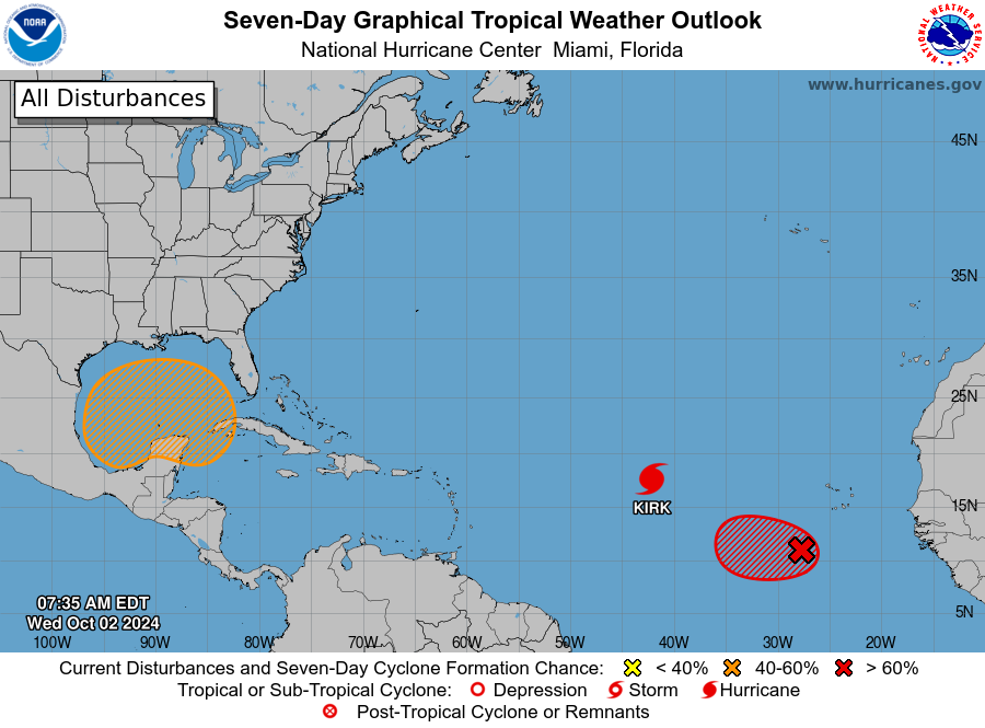
Although some sort of tropical system may develop in the central or southern Gulf of Mexico over the next week, it is not likely to have a significant effect on our weather in Texas.

Need rain in the Katy area badly!
I’m sorry but 96 degrees in OCTOBER? Climate change is really making these miserable summers last longer.
Reached that temperature at both airport for peoples’ information.
Ouch – that is excessive
That is true but ridiculous late season heat has kind of always been a thing in SE Texas. The hottest October temperature in Houston is 99 degrees back on October 1st 1900. Before the urban heat island affect mind you.
Also, todays record is 97 from 1938.
That’s true, there have been days like these in 1900, 1938, and 1962. But we also hit 95 in 2015 (IAH only), 2017, 2023, and now 2024. Both urbanization and climate change play a huge factor for these increasingly brutal late summers.
Very true and the summers have been staring earlier on average as well. We had a peak heat index of 115+ across the region last May 28th. We have never had heat index values that high in May before. That was a direct result of water temperatures being much warmer than normal, which is one of the main symptoms of a warming world. The excess water vapor release from the oceans makes the heat even more dangerous. We always had freak anomalies like the record hot May of 1996, the freak Summer of 1980, and 1998, but those were the exceptions not the rule like in recent years. Over the past 15 years we have been experiencing late July and August type weather in mid June more often than before as well.
I also believe massive urbanization combined with cyclic climate changes make freak weather anomalies, more common..For instance we experienced a hurricane in early July..I honestly thought I was going to swim and beach all through July without having to worry about hurricanes hitting our area..And then Beryl came to visit..
I think the urbanization over the decades, also the past century hasn’t helped with flooding however…Space is a finite thing..If we need space to spread out with our new housing developments/businesses, we should probably expand upwards instead of taking up more land..
Urbanization most definitely exacerbates flooding. The more big cities expand due to the endless growing population the less rain it’s going to take to overwhelm bayus and rivers cause all the rain that falls is just going to runoff the extra concrete and rooftops into the nearest creek or river instead of soaking into natural land and trees. Urbanization is partly what made the flooding in Harvey so bad. Don’t get me wrong Harvey would still have been a major flood event without urbanization but it definitely made it a little worse than it would have been naturally.
Hurricane Beryl was caused by unusually warm ocean temperatures and ripe atmospheric conditions. It was the earliest cat 5 on record before entering the Gulf. It would have been much worse for us if Beryl wasn’t battling dry air on its trip to Texas. We got very lucky. July hurricanes are pretty uncommon for Texas. If I’m not mistaken, the last hurricane to strike our area in July was Claudette back in 2003. That was a cat 1 that made landfall in southern Matagorda County. It tore up parts of Matagorda and Brazoria County but it traveled westward. I don’t think it affected the Houston area much.
I Am Hopeful That Southeast Texas Is For The Most Part Done With This Hurricane Season.
Me too!
It’s Halloween time 🧡👻🧡
Previous threads have often suggested North Carolina as a possible relocation alternative to getting out of Houston. A friend did some years ago and now has lost everything – and nearly his life. We should be careful for what we wish for. Houston is crap – no doubt abut that – but other places are not so perfect either.
I have to agree on that..My sister lives in the beautiful mountains of Colorado..Her backyard is a huge open space..She loves her life there..Until she has to evacuate wildfires..
My thinking is this..We have to watch for hurricanes EVERY SINGLE YEAR on the REGULAR, if we live on the coast..So there is risk vs payoff..If one loves to live on the beach, then for most people this comes with plans and preparation for hurricane season..They usually want to build to resist the floods and hurricanes..They have an evacuation plan of some kind..
As imperfect as places many hundreds of miles inland are, they may be more livable for those people fed up with the yearly hurricane preparations, having to repair hurricane damages, or having to rebuild every few years….Especially people like me, who have only a moderate income that limits my options..
Based on history, it’s not hard to hope, or even assume it will be decades before another full strength hurricane hits the middle of the country badly enough to cause the kind of destruction we saw with Helene..
I’m feeling old, and am getting tired of worrying about hurricanes yearly..We’ve done both evacuation and ride outs over the years..
There will come a point, when I want to hedge my bets and decide to move to North or Central Texas..Or Arizona, or New Mexico, as imperfect as they are..So that I won’t have to dread late summer and early fall EVERY single year..
Sadly, North or Central Texas is dry and can be very hot in the summer and very cold in the winter – plus they get tornadoes. New Mexico has little to offer except Taos which is very pricey and has similar climate to the previous location ideas. Arizona is a migrant and retirees haven with a climate nearer to the Sahara. So, I’m afraid you are stuck here with the rest of us.
Actually, once one is inside one’s own home, one can really imagine oneself anywhere in the world. Remember the old adage: Bloom where you are planted.
I’m used to the very cold..I used to live and study in Chicago..Would walk to school in the aftermath of a blizzard after sidewalks were cleared..
Also I lived in TN…I lived in California as a child..
We moved to Texas in the early 80s for work..
I enjoy 4 distinct seasons in a year..
With that said I have grown roots and made my home here near the coast (not immediate coast)..Same home now going on 40 years..
I’m probably not moving unless health or mobility makes it extremely hard for me to deal with hurricane evacuations or ride outs..We do not have a home generator, because we evacuate hurricanes more often than we ride them out..
I am pushing 70..I don’t know how many zesty years I have left of being an energizer bunny that deals well with hurricane aftermath lol..
So.tired.of.the.heat.