In brief: In today’s update we review our warmer than normal October, which ended up tied for the sixth warmest October on record in Houston. We also look ahead to roller-coaster weather this week, with rising temperatures before a front late this weekend.
October review
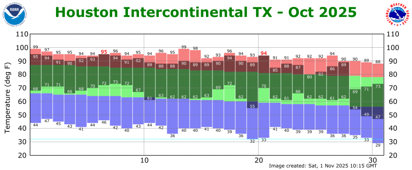
If you look closely at the chart above, you can see that every daytime temperature in October was warmer than normal until the cold front at the end of the month, which dropped us nicely into fall-like weather. Thanks to this turnaround Houston did not end up with the warmest October in the city’s history. Rather, the average temperature of 76.0 degrees (4.2 degrees above normal) tied for the sixth warmest October on record. Our days were especially warm, averaging 88 degrees across the month, when the normal high is just 82.8 degrees.
Monday
The forecast for this week will be straightforward, with sunny skies expected to prevail from dawn to dusk. The big changes of note will be the return of the onshore flow on Tuesday, and then a front this weekend. Aside from that, everything is small details. Anyway, for today we can expect mild temperatures in the mid-70s, with light easterly winds skies. Skies will be full sunshine. Lows tonight will be similar to those of Sunday night, in the low 50s for most locations, although it will be cooler further inland, and warmer near the coast.
Tuesday
Expect another sunny day, this time with highs in the upper 70s. As winds shift to come from the southeast we will see a warmer night, with most locations dropping into the upper 50s or lower 60s.
Wednesday, Thursday, and Friday
These days will bring mostly sunny skies and slowly warming conditions. Highs in Wednesday will likely be in the lower 80s, rising to mid- to possibly upper-80s (for a few areas) by the end of the week. With dewpoints solidly in the 60s this weather will feel fairly humid, but not oppressively so. Lows during the second half of the week will only fall into the mid-60s for most locations. Basically, did you like the weather during the second half of October? Because it’s coming back for a couple of days.
Saturday and Sunday
Saturday should be fairly warm (mid- to upper-80s) and mostly sunny. A front is on the way this weekend, but right now the timing is a bit uncertain. I think it probably will arrive sometime during the day on Sunday, and this will impact our temperatures. At this point most of our model guidance indicates a dry passage, but it is possible we see a few very light showers with the front. Anyway, highs on Sunday will probably be somewhere in the low- to mid-80s depending on the timing of the front.
Next week
The first half of next week looks cooler, with highs in 70s and lows probably in the 50s in Houston (40s possible further inland). A warm-up of sorts is possible later next week, possibly into the lower 80s. We’ll see!
