In brief: Today’s post shares some thoughts about the beginning of the Atlantic hurricane season, which fortunately appears to be starting slow. We also look ahead to some modest rain chances to start the week before high pressure and Saharan dust push our highs toward triple digits by the weekend.
Hurricane season begins
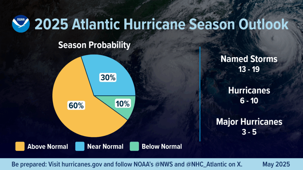
The Atlantic Hurricane season officially kicked off on Sunday, June 1. The season nominally lasts for six months, but longtime Houston residents will know that the season usually starts slow, and reaches its crescendo for our region in August and September, before the threat diminishes rapidly by the start of October. So it’s a long slog, but for us it’s typically a four-month slog rather than half a year.
April and May are what I like to call “hurricane season forecast season,” and we’ve seen dozens of outlooks. Having read most of them, I can tell you that almost everyone is calling for near-normal, or modestly above-normal activity this year. The reality is there are no hugely strong signals for what to expect. It does not appear as though El Niño or La Niña will have a major impact on the season, and although sea surface temperatures in the Atlantic are running above normal, they’re not excessively so. We have a deeper rundown of all of this on The Eyewall, but to be honest, none of it matters a whole lot. As always, prepare for any given hurricane season like normal, whatever the forecast is.
As for the tropical outlook for the near future, as usual we have been seeing the US Global Forecasting model throwing out some wild solutions for a Gulf hurricane in the 10 to 16 day portion of its forecast. This is typical for this time of year, and can likely be safely ignored. We will, of course, continue to watch things closely and update Space City Weather with any tropical information that Texas residents need to know. For now it looks like we’re going to slide into the season quietly for at least the next week or so.
The most important advice I can give you is that a little bit of preparation goes a long way. Understand your vulnerabilities to wind, storm surge, and inland flooding, and know under what circumstances you would stay, and under which you will leave. Then make a plan for the supplies needed to hunker down; and have an idea of where you would evacuate to and what you would bring. With these plans made, you will be able to face whatever challenges arise this season with a measure of confidence. We promise that we’ll be here every step of the way.
Message from our long-time partner, Reliant
We first began supporting Space City Weather during the 2017 hurricane season (i.e. Harvey!) and have been grateful to Eric, Matt and the team ever since for keeping Texans informed and prepared during inclement weather. We certainly hope this year’s hurricane season will be a quiet one, but regardless, Reliant and Space City Weather will be there for you.
Take the time now to protect your family, home and business. Let this official kickoff serve as a reminder to prepare now, before the height of hurricane season here in Texas. Here are some tips to get you started:
- Create or update an emergency kit to ensure you’re stocked up on essentials like nonperishable food, water, medical supplies, flashlights and radios. Be sure to customize your kit to fit your family’s personal needs.
- Develop or refresh a communication plan with your family. This will ensure everyone is informed, on the same page and operating in a way that maximizes their safety. This includes sharing emergency contact info, including an out-of-state contact and enabling your phone’s emergency alerts.
- Protect vital documents so you can easily identify yourself, submit insurance claims and request assistance. Important files, including personal, financial and legal documents, should be saved in a waterproof, fireproof bag and backed up digitally.
- Know how to shut off water, gas and electricity in case of an emergency.
- Invest in backup power. Backup energy solutions can help you ride out the storm, including portable options or whole-home generators like the one Eric and Matt have.
Check out more preparedness tips and recovery resources at The Reliant Storm Center: reliantstormcenter.com.
Monday
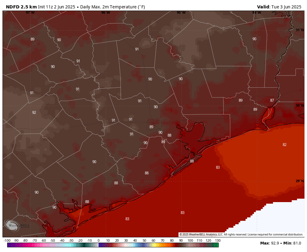
We’re starting June off warm, but not excessively so. Today should bring sunny skies and high temperatures in the vicinity of 90 degrees. Winds will be generally light, from the southeast at 5 to 10 mph. Lows will be modest, in the mid-70s. Compared to what is coming, this represents a rather benign start to summer in Houston (which for my money, also begins June 1).
Tuesday and Wednesday
Both of these days will have a puncher’s chance of some showers as a front drops into central Texas, but won’t reach all the way to our region. I’d say there’s about a 20 or 30 percent likelihood of rain, with the barest chance of a thunderstorms. Most of us will see partly to mostly sunny skies most of the time, with highs in the vicinity of 90 degrees. As for humidity, we’ve reached that point of the year where the humidity is going to be high every day in Houston. It’s a fact of life. Anyway, if you’re not impressed with the rain chances these days, they’re far better than what’s to come.
Thursday and Friday
These days should be a little warmer, with mostly sunny skies. Two things are going to happen during the second half of the week that are really going to make it feel like summer around here. One is that high pressure will begin to build from the south. And secondly, we’ll see an influx of Saharan dust that will turn our sunsets redder and help to clamp down on atmospheric moisture. The bottom line? Expect highs in the low 90s on Thursday and Friday as we transition into this pattern.
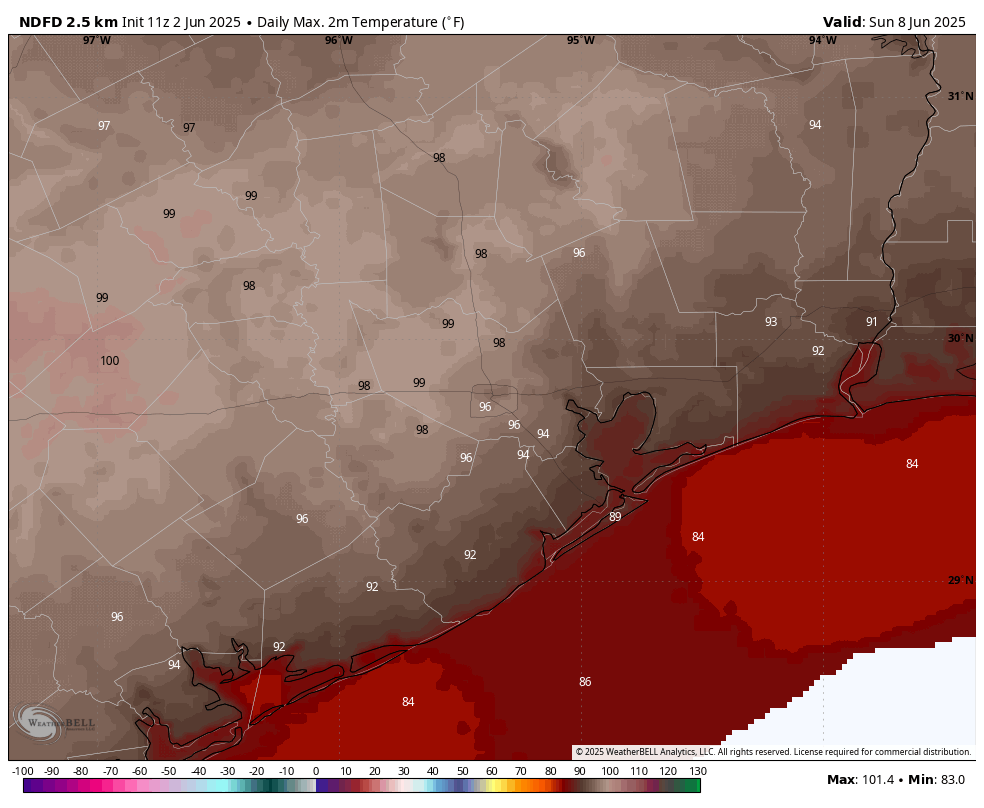
Saturday and Sunday
Our temperatures should be solidly in the mid-90s to upper-90s this coming weekend, with sunny skies. Lows likely will be in the upper 70s. Need I say more?
Next week
The hot pattern continues for a couple of more days next week before there’s a possibility of some slight relief. This would take the form of some scattered showers and slightly lower daytime temperatures. But we’re still going to be in the 90s.

As always accurate and timely advice – thanks!
Valuable documents need to be kept in a waterproof and fireproof safe. Most safes are neither as they are designed to protect your valuables from thieves and not the elements.
Documents should be inside fire sleeves when inside fireproof safes as well!
We just experienced the 4th warnest May on record. Last April was also the 4th warmest April on record. Last March was the 9th warmest on record. 7 months from last year, were amongst the top 10 warmest on record. There seems to be a trend going on here, I can’t quite put my finger on it, though.
Galveston alone had weather records to 1871, west Texas starts around 1900 when new mercury-shock glass thermometers and nerds spread. Even from normal variation the temps can ramp up and down each decade, 30s was hot. Unlike Europe with folk memory of monks writing stuff, wow us in US have little idea what NORMAL DECADE VARIATION we could face, good and bad, we aren’t Europe. A
I’m not sure what your point is, but average temperatures have been steadily rising globally for decades now. Specific regions experiencing brief fluctuations have not altered the overall gradual upward trend in global temperatures. Periods of abnormal heat have become commonplace now as a result.
We have all seen the trends… in your repeated daily messages.
There are over 15 Uhaul outlets in the greater Houston area where you can rent moving trucks.
I plan to have a professional mover handle mine. It will be to a place (TBD) at least 200 miles from the Gulf of Mexico.
Just go ahead and say it…. it’s right on the tip of your tongue….. you’re battling your conscious wanting to say it….. just spit it out already 🤣🤣🤣
This year, summer began on May 13th, which is not far from normal. I consider the official beginning of summer to be when we start consistently having highs in the upper 80s to low 90s with lows in the 70s.
“Be prepared, not scared”.
I prefer to be prepared and paranoid for the next six months. It’s one of the main reasons I moving well away from the Gulf of Mexico, or the Atlantic, when I retire.
Noticed last night that GFS was brewing up one of their early season “scare-i-canes” for Houston at the end of the month. Actually, a “scare-i-tropical storm”. I’d ignore it, folks.
Everyone, today, at Kroger buy $50 bottle water, $50 peanut butter and jam and crackers, $50 garbage bags (handy and in pinch add warmth). On Amazon or ebay $50 USB fans $10 each (they cool so much), $100 lithium battery packs gets 4 brick sized each with 100 phone jumps. $300 in total, cost of hotel room. Fans especially make week without power OK. A
Thanks Tom …
Native Texans here, so no kroger for us. (HEB)
Agreed on stocking plenty of water.
And yea, battery-operated fans are a good idea.
Lithium battery charging packs are good … we use our vehicles to charge our phones.
We prefer “snack on the run” packages (small box includes a small can of tuna or chicken, crackers, and a baby spoon),
A box of fruit bars,
Canned veggies, and canned meat-sorta products (pescatarians here)
A box of “fruit cups” (diced fruit in plastic sealed containers),
Dry-shelf milk (you know, the milk that’s not found in the fridge dairy section)
If your stove-top is gas fed, but needs power for igniting, have matches handy (or click lighter)
I know I’m missing some other simple tricks of the hurricane outage trade 🙂
Aggie, Lights are a vastly overlooked piece of kit in my opinion. Lanterns, flashlights, and headlamps have proven invaluable to me while working on my generator, navigating the house, and generally working during evening/morning hours.
Also an emergency radio, as the cell towers will be too overloaded after a storm to do anything more than send texts. Not only does it provide great updates, but also it just breaks the silence and hum of the generators.
I had all that stuff last year – esp the D cell operated fans/lanterns – oh clever me, I thought. Went through the amped up so-called ‘cat 1’ Beryl. Of course the power the went out, but then it stayed out. Once that heat begins cooking your place, heat illness starts setting in. That’s a serious, serious business. You can become slowly ill & not realize it (those fans did help for a little bit, but they could not combat the oppressive conditions).
So, by the next day, it became clear the power wasn’t coming back on. So, we evacuated after the storm. The most valuable thing we did was make sure the vehicle was gassed up before that storm.
(I didn’t want to evac after my Rita experience – from which I learned to always have a good gas syphon).
Prioritize & keep presence of mind. Make sure you can leave, esp w the amped up probability of a rapid intensifying storm and a dearth of radiosonde info.
“Be prepared, not scared.”
I plan on being prepared and paranoid for the next six months.
It does look like the GFS is brewing up its usual “scareicane” for the end of this month -headed for Houston, of course. More like a “scare-a-tropical storm”. I would ignore it, folks.
Yea, I replied about GFS goofing up on EyeWall website. About 6am today, GFS showed a hit to Corpus Jun16 (using Ventuski).
But NOW, it shows the hit to HOU area. Switch to ECMWF model – nothing.
GFS is definitely hallucinating.
Looking that far out in time, models will change each run
Yeah, the GFS is expecting a storm to arise in the Caribbean when the MJO arrives around the 9th (I guess to grace the psuedo-gyre). I guess they’ll play together.
The Euro shows storminess on the E Pac side, but storminess that stays broken up. Rooting for the Euro.
Well, just checked the NHC website and we now have Disturbance 1 (Atlantic) off the south-eastern coast. 10% for 7 days, 0% for 2 days.
Is there any way to know how a high rise apartment in Uptown would fare in the eyewall of a progressive storm making landfall at 150 MPH ?
A lot of variables involved, but 150 is well into de-roofing and window blow-in speed, but you’re unlikely to see those speeds on Uptown.
The head of FEMA just learned there as a hurricane season. Maybe SCW should send him this article.