In brief: In today’s post we dive into the latest data about the impending winter storm and share our thoughts about freezing rain, hard freezes, and more in Houston. There is also a new wrinkle, with the potential for thunderstorms on Saturday morning. Because, why not?
Winter Storm overview
We continue to monitor the impacts from an Arctic front that will arrive this weekend in the Houston region. Friday and Saturday should be fine for getting around, although in a new wrinkle we now anticipate the potential for some thunderstorms on Saturday morning. Fortunately this will fall just as rain. We are still watching closely for when temperatures reach the freezing mark in the metro area, as that will make all the difference as to whether we see freezing rain and icy roads on Sunday morning. See below for a full discussion of all this.
Friday
We are seeing plenty of fog across the area this morning, with light winds, and temperatures and dewpoints both settling at about 60 degrees. Highs today will push into the upper 60s, with mostly cloudy skies. We could see a few light showers, but these should be nothing to write home about. Lows tonight should drop into the 50s, area-wide, as the initial push of colder air arrives from the cold front.
Saturday
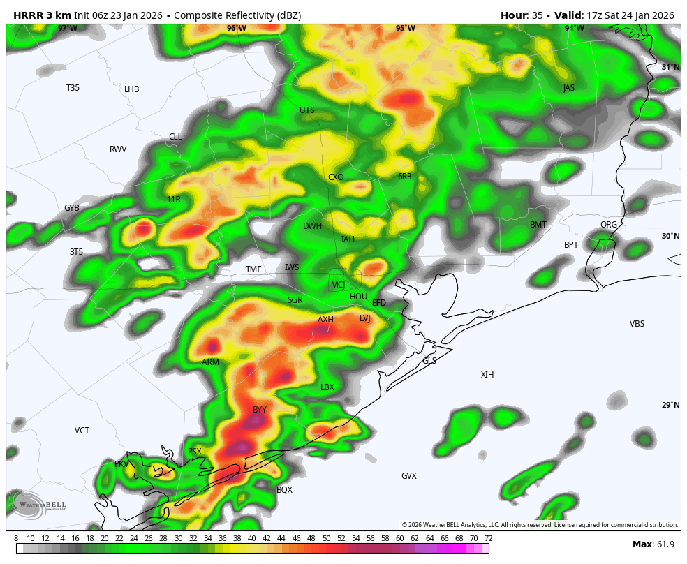
There’s a new threat to talk about on Saturday. There will be an interesting setup with very moist, and warm air offshore and much colder air over inland parts of Texas. This could well lead to the development of some thunderstorms during the mid-morning hours on Saturday, as essentially a line of storms pushes through. This is likely to drop 0.5 to 1.0 inch of rain pretty quickly, and I hope the city’s efforts to treat bridges and overpasses for ice (which may come later) takes this rainfall into account. With temperatures likely around 50 degrees in Houston on Saturday, this will indeed just fall as rain.
After these showers and storms move through, we could see an end to precipitation for awhile on Saturday afternoon, although our skies will remain mostly cloudy. Temperatures likely will hover in the 40s during the afternoon hours, with modest northerly winds. At some point on Saturday evening to Saturday night, freezing temperatures will start to get closer to the area. They could arrive in Montgomery County by around 9 pm to midnight, and likely not moving into Harris and counties closer to the coast until after midnight or later. I expect area roadways to remain passable, at the very least, through Saturday evening.
Sunday
Ahh, Sunday. This day remains the bane of a forecaster’s existence. We really need to know precise temperatures throughout the day, literally to within a degree, and as of yet we still don’t have that kind of certainty.
With that said, I expect to see additional light showers overnight on Saturday into Sunday, followed by what may be a second line of showers and thunderstorms around sunrise on Sunday, or shortly thereafter. And then the rain should exit to our east, for good.
Question no. 1 is: How cold with temperatures be across the metro area at sunrise on Sunday? If they’re below freezing at your location, there’s a decent chance of some minor ice accumulation. If they’re above freezing at your location, it’s just very cold rain. I think there’s about a 50 percent chance of freezing temperatures in a location such as The Woodlands at this time, and perhaps less than 50 percent along the I-10 corridor in Houston, and less still south of there. So when you wake up on Sunday and consider going out and about, you’re going to need to be weather aware. Check local temperatures. See if the precipitation has moved on. Read what we’re saying here. Roads on Sunday morning may be fine. They may be mostly OK with some issues on elevated surfaces. Or it may be pretty icy out there and you should stay inside.
For now our best guess (emphasis on guess) is this: There could be up to 0.2 inch of ice accumulation in Montgomery County, especially along and north of Highway 105. Ares of northwest Harris County, as well as Waller and Austin counties, may see some minor ice accumulations. Areas closer to the coast probably will not.
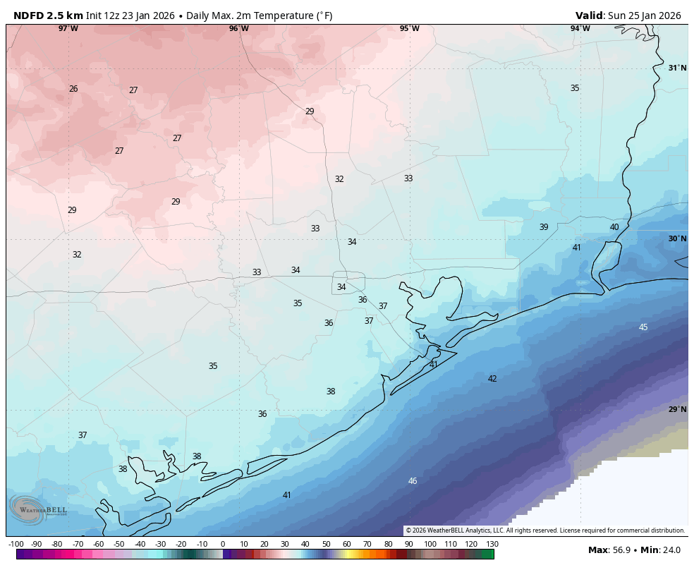
Question no. 2 is: How warm will temperatures get on Sunday afternoon? As precipitation exits to the east, we should see some partially clearing skies on Sunday. With gusty northwesterly winds (perhaps up to 25 mph from the north) we are going to see a lot of very cold air advecting in. If temperatures are above freezing in your location for a couple of hours, with a little sunshine and these winds, we are going to see good conditions to dry out roads. However, if temperatures remain at or below freezing at your location, any ice is going to stick around. My general guess is that we are going to see roads dry out, at least in non-shadowed areas. But an alternative possibility is that we don’t get enough heat or sunlight before frigid temperatures descend Sunday evening. Again this is going to have to be a game time decision.
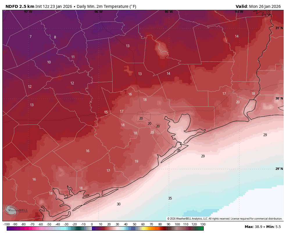
We remain highly confident in temperatures plunging on Sunday night, probably down to the 20-25 degree range in urban Houston, with conditions a little warmer closer to the coast, and a little cooler in places like Katy and The Woodlands (15 to 25 degrees). Note there still is some uncertainty about how cold it will get.
Monday
What roads look like on Monday morning will depend on what they looked like Sunday evening. We are not going to see any additional precipitation, so if they’re dry on Sunday night, they’ll be dry on Monday morning. We should see temperatures climb to highs between 35 and 40 degrees on Monday, and with clear skies and light winds, we can expect another very cold night. Temperatures likely only be 1 to 3 degrees above conditions on Sunday night.
Tuesday and beyond
We’ll warm up a little next week, likely with highs in the 50s and lows in the 30s until Thursday or Friday. After that time there’s the potential for a secondary Arctic blast, although I don’t think the overall airmass is going to be quite as cold this time. However there is also a non-zero chance of some snow with this system. But it’s all pretty fuzzy, and the models are hopping around a lot from run-to-run. So we’re not going to speculate too much here.
Our next update will be posted by or before 3 pm CT today.
A message from Reliant
If you’re new to our website, welcome. We recently celebrated the tenth anniversary of Space City Weather, and have always been—and always will be—free and freely available with no paywalls. We do not track our readers or collect their personal information. This is possible because of our readers who contribute to our annual fundraiser, and our long-time sponsor, Reliant. They have been our valued partner since 2017, and have helped us grow over that time. Today they want to offer a few tips to help you stay warm and manage electricity usage during upcoming freeze.
Try space heaters in high-traffic rooms. Lower your thermostat and use an energy-efficient space heater in rooms where you spend the most time.
Check your thermostat. If you have an electric heater, set the thermostat to 68 degrees while you’re awake. Lower it and add an extra blanket while you sleep to save energy.
Use your drapes. Thermal drapes can help block drafts and retain heat, especially on older windows. Open south-facing curtains during the day to let in sunlight and close them at night to trap warmth.
Invest in smart plugs and smart power strips. These allow you to control the power supply to devices remotely via a smartphone app. This way, you can easily shut off power to devices not in use, even when you’re not at home.
Layer up. Reach for a sweater or blanket before reaching for the thermostat. Weather-appropriate clothes help reduce the demand for heat. Plug in your electric blanket and stay warm for around 25 cents a day.
Install insulation. While more of a long-term project, you can regulate your home’s temperature and reduce heating costs by adding insulation.
Weatherstrip exterior doors and windows. With a couple of hours’ work, you can seal out the cold and save up to 10 percent on total energy costs.
