In brief: The coolest morning since spring has brought crisp conditions to Houston today! Look for more of that tomorrow. A chance of showers will disrupt the forecast on Saturday, but additional pleasant fall weather should follow Sunday through Tuesday. We may then see a more significant warm up in temperatures later next week.
Apologies for the delay on this. I was a little absent-minded this morning and forgot I switched with Eric, who unlike myself actually runs on cool mornings! For those that have been waiting for this, congratulations! One of the five warmest Octobers on record in Houston has saved its most crisp weather for the end. Temperatures this morning were in the 40s and low 50s everywhere. Here’s a map of all places that clocked in at or below 46 degrees (because I can’t get the filter to sit at 45 degrees):
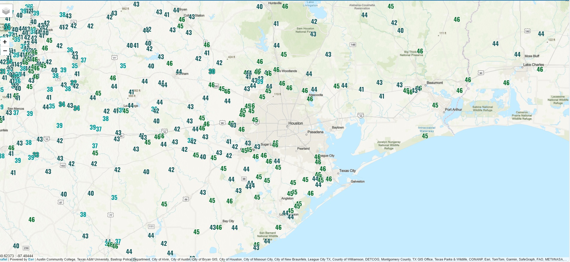
Some cool things to note on the map above are the presence of the urban heat island, where most areas inside the Beltway ended up closer to 50 degrees, as well as the influence of the Gulf and Galveston Bay, which moderates temperatures warmer near the coast.
Anyway, the good news is that we’ll have some delightful weather today, with much less wind.
Today and Friday
Look for ample sunshine today and tomorrow. High temperatures will peak near 70 today and probably in the mid-70s tomorrow. Humidity will remain low, and there will be generally light winds, except at the immediate coast today. Morning lows on Friday should be fairly similar to this morning.
Saturday
The one forecast hiccup comes Saturday. A weak reinforcing cool front is going to move in from the north. As it does so, we’ll see an increase in clouds and some scattered showers. Not everyone will see rain on Saturday. But at least scattered coverage and a few isolated thunderstorms seem likely. After morning lows in the 50s, look for daytime highs in the 70s.
Sunday
The air mass behind this front will be less potent than what we’re currently seeing. Look for lows in the upper-40s and low-50s on Sunday. Winds will be notable, but a good 10 mph or more lower than what we saw on Wednesday. Gusts of 20 to 30 mph will be possible, especially along the immediate Gulf coast. Other than the breeze, expect sunshine.
Next week
Quiet weather locks in for most of next week it appears. Temperatures will begin to warm up with highs in the low-70s Monday, mid-70s Tuesday, and near 80 on Wednesday. Warm weather may linger deep into next week or weekend.
It does look like the first half of November may pick up where October left off last week. I anticipate we will see a front or two sneak in eventually, but in general, warmer and drier than normal weather is expected to dominate the front half of November.
