In brief: We are continuing to track a couple of tropical threats to the Gulf of Mexico. To put this into perspective, we’re sharing content published earlier today on The Eyewall. Though a serious system is not likely to develop, locally heavy rain and flash flooding are a good bet along the coasts of Texas and Louisiana during the middle of next week.
As of this afternoon the northern Gulf of Mexico looks fairly spicy when it comes to tropical activity, and the system in the northern Gulf of Mexico has now been dubbed Invest 90L. It’s drifting southward, while a lot of its moisture gets sheared off to the east. Basically, it’s beginning the transition into its next phase of life now.
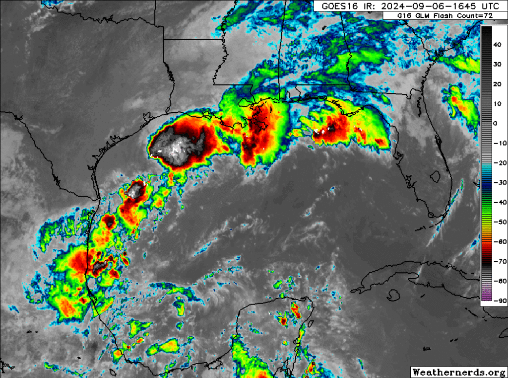
From here, 90L should drift all the way south into the Bay of Campeche where it’s going to finally meet up with the tropical wave we’ve been discussing ad nauseum that’s exiting the Caribbean today. Whether this gets classified as Invest 91L or stays 90L, I don’t know. It’s a procedural mystery. Whatever the case, I’m going to refer to it as 90L.
Anyway, by the time we get to Sunday, this whole mass congeals in the Bay of Campeche. It probably won’t develop right away, but it will begin to stir a bit.
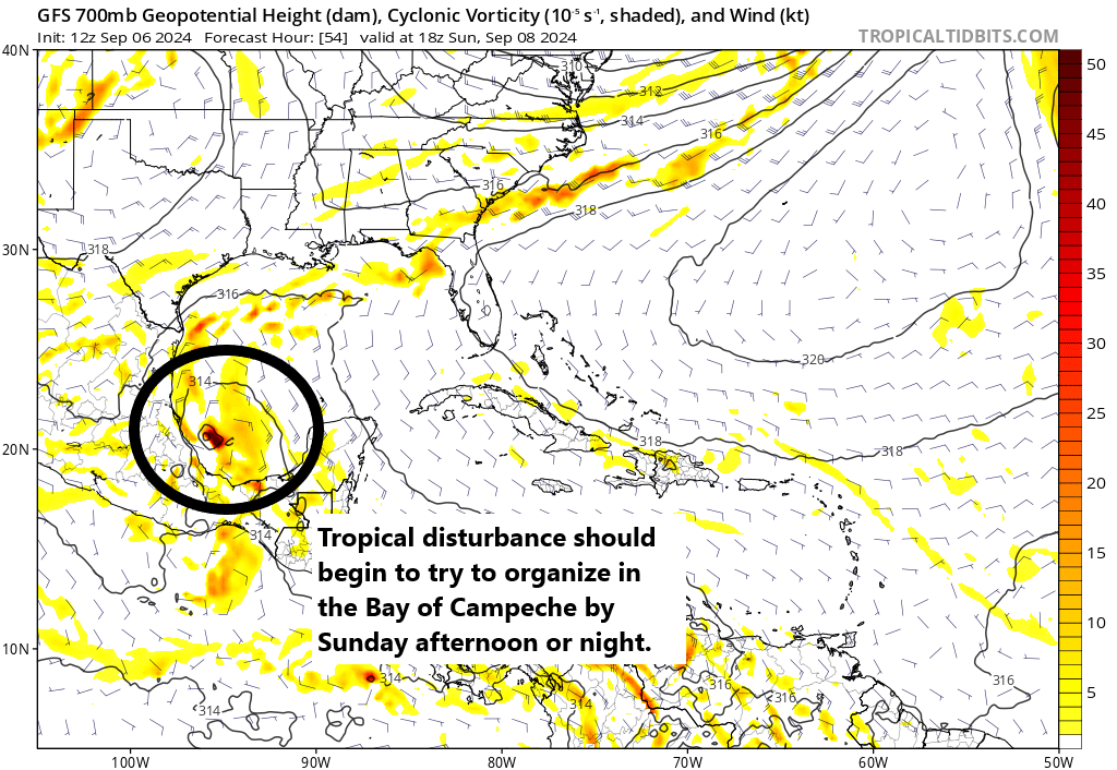
In general, from here we expect this thing to track northward. I think we stop at this point in terms of talking about specifics. Everything becomes kind of theoretical. If 90L forms farther offshore, it may have a better chance to organize a bit more and track more due north or north-northeast toward extreme east Texas. The stronger it gets, the farther northeast it will go, deeper into Louisiana. If 90L continues to hug the coast of Mexico, as shown on the GFS here, it would likely try to become a tropical storm and then slide inland. A weak system would probably come ashore *in* Mexico, whereas a slightly more organized depression or tropical storm would track more toward the Texas coast.
The ceiling on this is *probably* below hurricane intensity right now, if it develops. Never say never obviously, but virtually all the signals we are getting from tropical models, operational models, and ensemble guidance keeps this as a tropical storm or weaker. So from a “will we see widespread power outages and/or major hurricane damage” perspective, the answer is almost certainly not at this point.
But, I would advise folks between northern Mexico and Vermilion Bay in Louisiana to keep monitoring this through the weekend.
Gulf Coast rainfall concerns
Now, the bigger concern I have with this system is rain. Rainfall over the last 10 days or so has been prolific in portions of Texas and Louisiana.
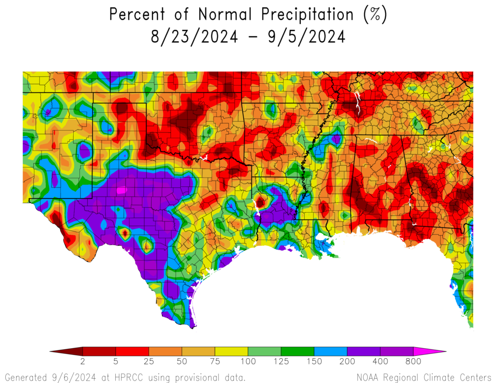
The Houston area has been primarily spared significant rain, but Galveston has seen over 10 inches. Louisiana has seen significant totals also. As has Corpus Christi. So there are a lot of vulnerable areas in between some areas that could handle rain fine next week. I won’t post a rainfall forecast because that outcome will depend on if a storm develops and how it tracks. There will be locally heavy rain even without a formal named storm, so no matter what, we’re looking at the potential for another 4 to 8 inches of rain or more in spots next week as this comes northward Tuesday through Thursday.
Bottom line: Check in on this again this weekend.

Hopefully this become another Beryl!
“Doesn’t” become another Beryl
“Doesn’t” become another Beryl
It won’t. We’ll be lucky this time.
“will we see widespread power outages”…. with minimal rain we lost power yesterday ….even though we were notified in early Aug that “CenterPoint crews and authorized contractors will be working in your area in the coming days to improve resiliency and help reduce the risk of outages this hurricane season.”
40%-50% of the latest most widely used models show a disturbance with barometric pressure 980s hitting Houston / Galveston almost dead on..Thoughts?
Yes this is likely going to affect Houston.
What information do you have that makes you so sure?
Look at this mornings model runs, tropical tidbits…GFS, CMC, ICON, all agree, straight into Galveston / Houston with a barometric pressure high 980s, low 990s..Idk where that falls in strength or impacts..I hope we get updates today..I’m very concerned now…Weather people need to start sounding the alarm soon if this may be more than a tropical depression…
I just looked up 980s-990s barometric pressure…High end tropical storm, or Category 1 hurricane…
Hi @Lisa … the Ventusky website shows the path of 90L passing thru Houston area (slightly east) sometime between Sep10 to Sep11. I sent a screenshot of the potential path to family in Surfside and Lake Jackson, so they keep a watch.
Also, about 20 minutes ago, Mike at Fox26Houston also showed the same potential path with approx landfall Sep11. He was also cautious to not hype it up, just a “wait and see”.
I looked on the Tidbits site and there’s a 0hz and 6hz model. 0hz has a couple right at Houston/Galveston while the 6hz trends more east. Do you know which is the better one to use?
Expect some changes being a 4-5 days out. Don’t know which is more reliable of those versions.
*0z and 6z. Don’t know where I got the h
Here we go again . . .
Just hoping for no rain, or at least no lightning with the rain for the high school football games.
Bren lucky so far, knock on wood.
Beaumont/port Arthur area is slightly east of Houston. Will probably affect tx/la state line
Pray