In the September Q&A, even though we think Texas’ hurricane season is in our rear-view mirror, many of the queries we tackle this month are hurricane related. Oh, except for the one about humidity and swimming pool water!
Got questions you’d like us to consider for next month? Reply in the comments below, or use the Contact link on the blog’s home page.
Q, As I get older, and having been through Ike and Beryl in Pearland, I’m becoming much less willing to endure another major storm so close to the coast. If a Cat 4 or 5 were to hit somewhere near Freeport or Galveston, would living somewhere like Magnolia or Katy really offer much more protection than Pearland? After Beryl, we drove to Dallas and saw downed trees all the way through Madisonville, about halfway there.
A. You know, I had similar thoughts as we rode out Beryl in League City. It was an unpleasant experience. (Personal note: I’m very much not a storm chaser. I appreciate the video and images they capture, but I like my storms far away, thank you). I used to think that I would stay in place for a Category 1 or Category 2 hurricane, but with the wildly swaying trees during Beryl, I’m not sure any more.
As for what you’ve asked, there is no question that Magnolia (especially) or Katy would on average be less susceptible to impacts from wind than areas closer to the coast, including Pearland. However, much depends on the strength of the hurricane, the angle at which it strikes the coast, and the speed at which it moves inland. Let’s look at a reasonably good wind gust forecast for Beryl:
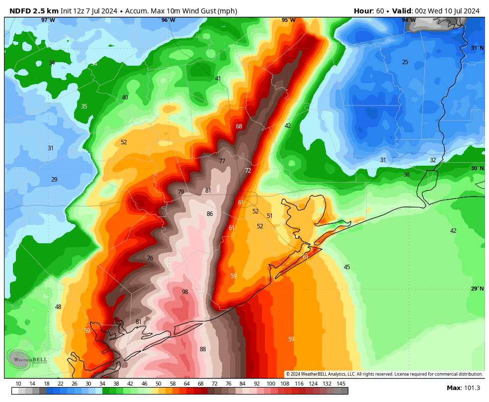
This is not exactly what happened, but it’s pretty close, and it is illustrative of what I want to talk about. Specifically, note how important the track, and proximity to the core, is for the strongest winds. Whereas some areas of Galveston County near the water experienced gusts well below that of hurricane force, areas north of Montgomery County, including San Jacinto County, were vulnerable to hurricane force gusts. This is more than 100 miles from the coast.
The bottom line here is that there are a lot of variables. In general, however, the further you live from the coast, the lower the odds that you’ll experience significant wind damage from a hurricane. But that doesn’t mean the odds are zero.
– Eric
Q: (Are) there any historical trends or data to predict a ‘strong’ winter weather (e.g. extremely cold) based upon the low hurricane season activity relevant to Houston? As well as broader US implications? Given our weather patterns are tied together, highs dragging hurricanes and lows pushing them.
A: So the simple answer is no, there is no consistent way to use hurricane season as a gauge for the upcoming winter. We also hear a lot of people say “Well we had a hurricane, so we’re getting snow this winter!” Back in 2021, I wrote a section in our winter outlook, specifically for Houston that showed, historically, a hurricane strike on Houston doesn’t mean anything really and that the odds of snow in a normal winter were pretty much identical to the odds of snow in a post-hurricane winter.
But in a broader sense, a weather company (WDT, which I believe is now part of DTN) published a post a few years back to correlate Accumulated Cyclone Energy (ACE) to winter temps, which found nearly no correlation. The atmosphere is complicated and singular weather events like hurricanes, whether frequent or infrequent are unlikely to have an appreciable impact on an entire season’s worth of weather 3-4 months later.
I will say, there has been some work done to try to quantify this at a hemispheric scale, and there have been some results. A professor at Florida State has done good work on this. So I think there may be something we will eventually be able to gather from all this, but it’s unlikely to be due to one ocean basin’s activity.
– Matt
Q. Love your content. I’m curious, the models you cite [during hurricane coverage] sound like the same ones we’ve been using. Are AI models in development? I wonder if we can dump them all into AI and see what it thinks…
A1. This is the first year that we’ve really begun to use AI models as tools for hurricane forecasting. (If you’re curious how they work, compared to traditional physics-based models, I wrote a longer article here). We’re going to need to get to the end of the hurricane season to know precisely how well they worked. At that point there will be some comprehensive studies done to calculate how well AI-based models handled hurricane tracks in comparison to physics-based models. But my sense is that, for a new product, they’re surprisingly useful. They’re another tool in the arsenal that we look at every day. Matt may have some thoughts about this as well.
– Eric
A2: I will add that specifically for this year’s Gulf storms, the European AI model (the AIFS) has done astoundingly well. It has locked in early on and has tended to front-run the other model guidance in the right direction. In my day to day with it, I have also found it to occasionally have some skill in snuffing out risks to the forecast, such as a cooldown in mid-summer. Perfect? No. Useful? I believe so. The AI suite will get a good test this winter of how reliable they are at picking out cold snaps or snowstorm risks in the Midwest/Northeast. But they are firmly in my toolkit daily now. –
–Matt
Q: This may have an obvious, easy answer but why am I constantly filling up the pool in the hot HUMID summer? I would figure dry air would sop up pool water (moisture) quickly but not so much air already saturated with water.
A: This is an interesting question, and your assumption is correct: More humid air tends to reduce evaporation of water in a pool. So the question then becomes, what’s going on?
One possible reason could be exposure to sun. If it’s in a lot of sun with limited tree coverage, even in high humidity, you’ll still deal with evaporation. Another possible explanation could be the very dry stretch we went through in August. The spigot shut off for an extended time, which probably didn’t help. Beyond those two explanations, there may be something else afoot! Probably something to monitor for pool maintenance folks, just in case!
–Matt
Q. I’ve noticed that many major hurricanes in the Gulf of Mexico during September and October tend to impact Louisiana and Florida more than Texas. I’m curious about the reasons behind this pattern. For example, does it have anything to do with the position of the Bermuda High or seasonal changes in weather patterns? Additionally, is it common for hurricanes to stop hitting Texas after mid-September, or are there historical exceptions?
A. I noticed this phenomenon nearly 20 years ago, and did a little research to figure out that after the date of September 24 the historical odds of a hurricane striking the state of Texas are about 1-in-50. So every year, around this date, I write something to the extent that the Texas hurricane season is pretty much over. (Here’s this year’s post). At some point I’ll probably be embarrassingly wrong about this, but generally, if we get to September 24 and things look quiet, it’s a fairly safe bet that we’re done with the threat of hurricanes. And I am talking about hurricanes—the odds of a tropical storm or depression are higher.
There are sound reasons why this is. Generally, as we get toward the end of September, the upper air pattern starts to change as the jet stream begins to move southward. This provides a generally eastward steering flow that we don’t see in August or earlier in September. A good indicator of this is when we start to get our first cool fronts (we’ve already had two this month). The big risk here, of course, is that the Caribbean Sea and Gulf of Mexico are still plenty warm in October to support hurricanes, so the threat is there. It’s just that, meteorologically speaking, it’s difficult for these storms to track westward into Texas. That’s not a taunt, mind you.
–Eric

Love your content and style. Thank you!!
I will never forget Harvey and how they released the Barker Cypress reservoir. My parents lived in Katy (since the 70’s) and had they lived only a few miles away they would have been flooded. I 10 was flooded and I couldn’t drive from Montrose to help them for a week.
Interesting about pool water evaporation. Our pool is surrounded by large live oak trees but we have been experiencing substantial loss of water, too.
I had assumed that our skimmer was leaking (which it has done before).
But maybe there is more to this than meets the eye????
Live oaks are infamous for breaking concrete with their roots, esp foundations. Their root system often spreads several times beyond their canopy and enwrap around water sources.
Just a thought.
Very interesting! I particularly appreciate this comment.
“The atmosphere is complicated…” 🙂
DaveinTX here. Also a Dave A by the way. Water will evaporate from the pool when it is sunny and hot. During the middle of the day, the humidity level actually goes down some, and evaporation rate increases. Just a fact of life….. Over the dry periods in the summer months, I need to add water to my pool about every 7 to 9 days. If we get significant rainfall, not so often, of course. When it is cooler and there is less sunlight, it drops to once every three weeks to even a month between intervals.
I come from UT. And up there, you had to add water to your pool about every other day during the summer months and 10% RH.
We can comment on the Magnolia thing.
Born in Houston – lived in the area 67 years now (various outlying areas). Harvey took away our Cypress property (5+ feet water in home). Harris County bought our Cypress property, as well as 20+ other acreage properties in that area.
HC assisted us to find a property that would not be at risk of flooding. It worked – HC approved our 10 acre property out here in Magnolia (even though it’s in Montgomery County ).
Lots of high winds during Beryl, but nothing significant, water-height wise. We’ve never had any water-height issues in the last six years.
Two comments here:
1) As long as the temperature is above the dew point, you’ll get some evaporation though more slowly as the difference between the two shrinks. The driving force is the difference between the absolute humidity (pounds of water vapor per pound of bone dry air) and the saturation humidity (100% relative humidity at a given temperature). So at 95 degrees, you get more evaporation in Arizona than Houston, but you still get evaporation in Houston.
2) As I mentioned over at The Eyewall, for me it’s looking like 300 miles inland when I retire in a few years. Even that isn’t always enough – North Carolina and Tennessee are supposed to get drenched by Helene.
No matter where you go, you either get forest fires and blizzards, OR hurricanes and flooding, or tornadoes. Nowhere is safe these days! But we will be heading towards CO after something happens with my MIL. My heart cannot take the stress of living down here much longer….. Been here for 27 years now.
43 years here for me. Leaving will be tough, but then again not so tough knowing I’m off to a better place to live.
Temperature is always above the dew point, unless 100% humidity, when they are equal
Whether to evac takes messy guesses, has another figured out the numbers. Evac is costly, like $3000, and heart attacks and car crashes rise… But luckily on avg a Hurricane hits a metro once each 5 years last decade… One cant move house, and can put items on shelves, so can’t change property losses. Big issue is risk to life — a Cat 1 even right at shore likely won’t kill people in houses just roof tiles and trees and maybe broken bones (this is half of H)– Cat 2 might kill 0.02% in shore county so if 100k and half evacuate that’s 10 dead (this is 1/4 of H). Cat 3 gets scary maybe 0.1% shore county and 0.1% second county so 200000 and half leave that’s 200 dead (so 0.1% risk if stay, but save $3000). Cat 3 is maybe 1/8 of H. Cat 4 is scarier, maybe 0.5% shore county and 0.1% another 5 counties (from trees and tornadoes), so if 5 counties are 100,000 plus 900,000 BUT HALF EVAC that’s 50 + 450. Cat 5 are too rare to ponder… Yes I’m guessing, but gotta start somewhere.. I don’t think they can pin down intensity well, so assume it’s a Cat 2…. Cat 2 is 0.02% risk if stay, which is less than risk of dying in car crash which is 0.05%… Or I could be wrong.
The adage I live by is run from the surge hide from the wind. This is also dependent on where you live, if there are giant trees around your house or you live on a bayou…
In my situation is Friendswood I don’t worry about storm surge but I have lots of trees. With that being said I made up my mind that I am close enough to danger that anything higher than a category 3 sends me packing…
Lets hope that the disturbance in the Western Caribbean doesn’t test the 1 in 50 odds of a hurricane hitting Texas in October!
Awesome article (as usual). I hope we can get the public away from the wrongheaded notion that AI “thinks”–it doesn’t. It is a model that uses statistics to guess at the next word.
Will SCW deploy the “Texas Needs to Monitor the Gulf Even Though Texas Hurricane Season is Over” headline Monday or sooner?