Man, will you look at the calendar! August’s almost done with us, but we are not done with it, which means it’s time for our monthly Space City Weather Q&A.
And yeah, we know, there wasn’t an installment in July. We have no excuses, other than to say that July was . . . a little busy.
Anyway, we’re reporting for duty now. On with your questions!
And don’t forget to to feed this beast: Post questions for future Q&A’s in the comments here, or use the Contact link below the blog’s header.
Q. If you were on summer vacation, at what time would you come back if there was something tropical-ish heading for Houston?
A. First, a word on my own plans for summer vacation. I try to never take them in August or September, because that’s the time I’m most concerned about when it comes to tropical weather and Houston. And when I travel in June or July, I definitely bring a laptop.
As for returning in the face of tropical weather, it’s really a difficult question because there are so many variables. Are you returning to prepare your house, only to evacuate again? Are you returning to prepare and hunker down? Are you most concerned about, wind, surge, or inland rainfall? That said, the fundamental question I would want to answer is how long you need to make whatever preparations you want to make before the storm hits. If it is 24 hours, then I would return no fewer than 24 hours before the onset of tropical conditions.
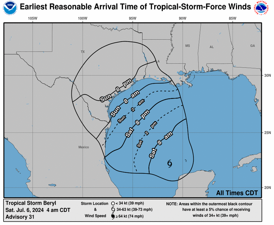
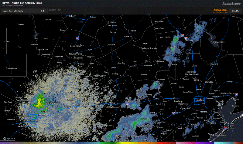
The National Hurricane Center has a useful tool for this you can use during active systems. This product offers a forecast for “earliest reasonable arrival” of tropical storm force winds. (The image below shows the forecast for Beryl, issued on the morning of Saturday July 6, for example). Essentially, this is a good guide to when final preparations for an impending storm should be made. We sometimes publish them on Space City Weather for this very purpose.
–Eric
Q. On Sunday, July 21, in a special weather statement for areas east of Houston, the statement talked about the risk of tropical funnel clouds. What are these and why is there a special weather statement for them vs. a tornado watch?
A. This is a good question. It’s a phenomenon we see frequently in Southeast Texas but not one we really talk a lot about. Tropical funnel clouds form typically when it’s humid and breezy. Why do they form? Funnel clouds form by similar processes both within supercell thunderstorms (which can produce tornadoes) and in these more benign tropical environments. With breezy, humid conditions, you can get a setup with a little bit of wind shear, especially near the coast, where wind direction may change with height. This can lead to some “spin” in the atmosphere, or what we call vorticity. As that vorticity gets stretched out a bit vertically, you get faster spin. And as that happens, you can get a funnel cloud.
So why are these benign? The process by which these funnel clouds form is much slower than the process by which supercell thunderstorms can produce funnel clouds and subsequently tornadoes. Additionally, they usually dissipate after a few minutes. Very few of these funnel clouds ever reach the ground, producing a tornado, and even if they were to do so, the tornado would likely cause minimal, minor damage. So they’re more likely to just get noted as a curiosity more than anything else. Because the process is slow to evolve and quick to dissipate, it doesn’t warrant a watch or warning.
–Matt
Q. My mom says she can remember back 10 or 20 years ago that Houston would normally get thunderstorms every day in the summer. Today it seems like long periods of no rain in the summer is the new normal. Has the weather pattern changed in the past 10 years? Or is it is just a lot drier where we live now (near Addicks Reservoir) than it is over downtown?
A. As best I can tell the patterns of summer rainfall have not really changed all that much in Houston, during the summer, over the last couple of decades. (That’s in contrast to temperatures, which have gone up strikingly, particularly at night). We have always been subject to prolonged periods of summertime high pressure during which there is no rainfall. Sometimes, as in last summer, these highs persist for months on end. This year, the high pressure pattern did not emerge until early August, in which case it hung around until the last week of the month.
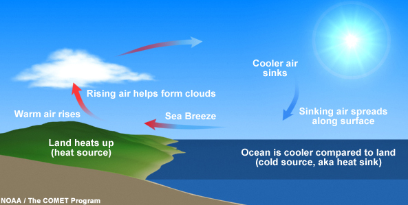
In June, July, and August, when we are on the periphery of a high pressure system, Houston summers are like the ones your mom described. This is due to the sea breeze, a pattern in which the land heats up faster than the Gulf of Mexico. This typically happens during the late morning or afternoon hours, and the rising air over land forms clouds a few thousand feet up at the lifting condensation level. This can then lead to the development of showers and thunderstorms. Some summers, particularly the ones your mom remembers, can see this type of pattern persist for weeks.
–Eric
Q. I saw a (radar) effect I can only describe as a rain “splash” or “bubble”. This is a ring of what appears to be very light rain, that starts centered on a newly forming cell and expands in all directions, rather quickly, before eventually dissipating. It appears like a two-dimensional cross section of a bubble inflating, or the expanding wave one might see after tossing a pebble into still water. Are you familiar with this phenomenon?
A. This is good opportunity for us to explain some common features you may see on weather radar that aren’t specifically precipitation. When you look at radar and you see what looks like a bunch of “noise,” as if there’s a bunch of light precipitation, we call this ground clutter.
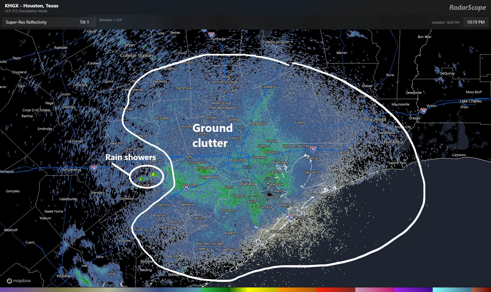
Ground clutter can literally be anything other than precipitation: Birds, bugs, bats, etc. can all make it up. You see it at every radar site. After awhile, you learn to disregard it. Radar can also pick up wind turbines.
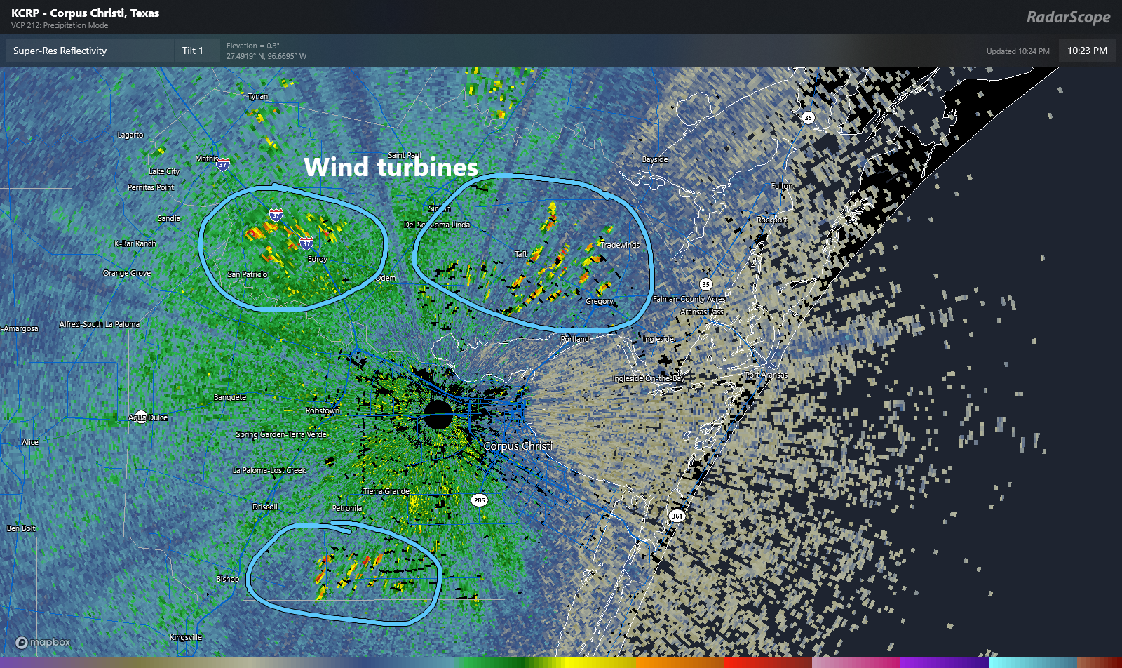
These can be a bit of a headache when you look at radar, but again, after awhile they sort of just become background noise to a seasoned user. I noted ground clutter above. How about bat colonies heading out for a night of snacking?
Similar to bats at sunset, you can see birds emerging from slumber during the morning, a phenomenon that looks like something is literally exploding on radar. These are just enormous flocks of birds taking off for the day from various locations. We call these “roost rings.”
Then, I think we get to what this reader asked about. If you look at this radar loop from July 17th in the afternoon, you can see numerous showers and thunderstorms over the Houston area generally propagating westward.
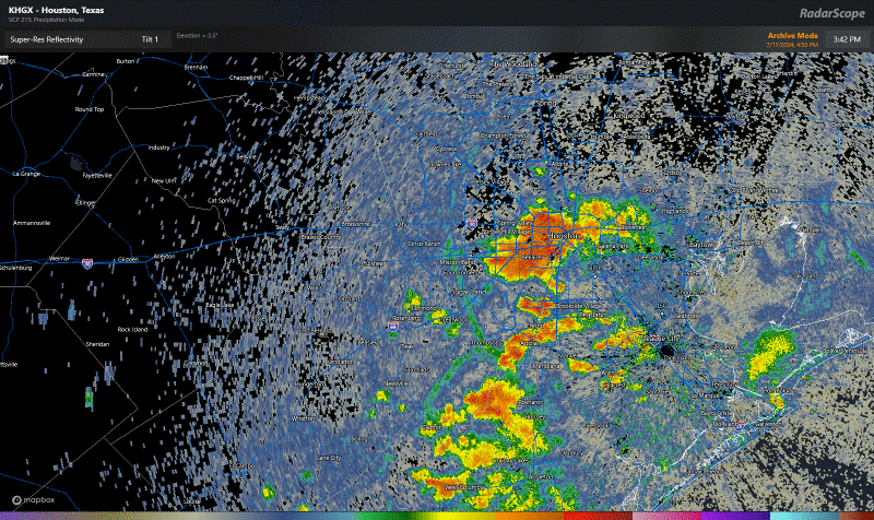
To the untrained eye, this is a chaotic mess of storminess. But if you look closer, the radar can actually tell you what’s happening here. Let’s zoom into Sugar Land and Greatwood down into Fort Bend County.
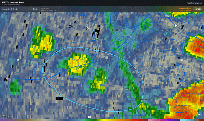
If you look right above and on the right side of what I circled on the loop above, you can see what looks like a “line” of green on the radar. We call these outflow boundaries or gust fronts. When we get thunderstorms, sometimes a cool breeze or cool gust of wind will move in before it starts raining. That’s what we call outflow, and you’re literally feeling the rain-cooled air come in ahead of the rain itself. In this case, outflow from the storms east of Greatwood, closer to Pearland was pushing west. Near Greatwood, it ran into another outflow boundary that was lifting northwest from storms down in Brazoria County. As the two boundaries collided, a new storm formed right over Highway 59/I-69, flared up and then weakened.
Such outflow boundaries are common in our area in summer. Sometimes, you’ll see what looks like outflow lifting north from the Gulf of Mexico. That’s the sea breeze, and once one storm pops on a hot day, it can create an effect of boundary collisions all over the place in erratic fashion. This explains why so often you’ll get a quick inch of rain whereas your neighbor 5 blocks away gets next to nothing. I liken it to atmospheric bumper cars: Pure chaos.
Anyway, now when you look at radar, maybe you’ll be able to detect some cool features too!
-Matt
Q. Do hurricanes come in clusters in certain parts of the Gulf and Atlantic? Several years ago, it seemed like Florida and the lower East Coast were getting slammed over and over. Then for a while the upper Gulf Coast was the big target. Is this faulty memory, or does this actually happen? And is it maybe the Texas coast’s turn?
A. The simple answer is: Yes, that can happen. Look back at 2020 when it seemed as if every storm had its mind set on Louisiana. But we can look back at some other seasons and see this concept in action. Let’s take 1995 for example.
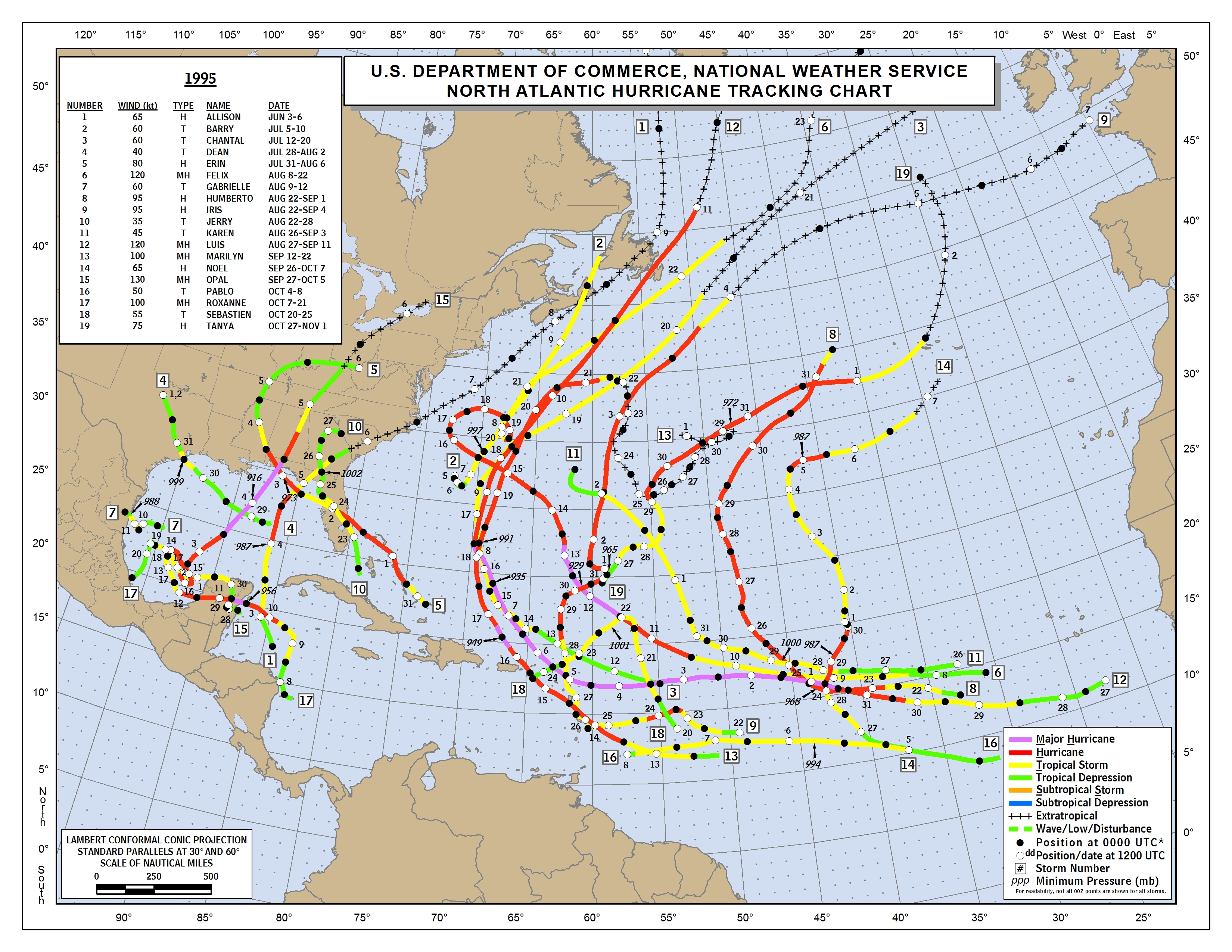
In 1995, there were 19 total storms. Many ended up in the Atlantic, clipping the Caribbean islands or just wandering out to sea. There was a secondary cluster of storms in the Gulf, particularly near the Florida Panhandle. 2010 was another season like that, where we had lots of storms clustered into two distinct areas. The first was out at sea as in 1995. But the second was focused on Central America and Mexico. But then you get seasons like 2017, where anyone and everyone was in play for hits from storms.
The reasons are tough to explain in a simple Q&A, but in general: The weather pattern in summertime can be semi-permanent. In other words, the Bermuda high over the Atlantic can sit in place for weeks at a time. Like we experienced last summer, high pressure can sit over Texas for weeks at a time. When patterns like this happen, it can sort of lead the atmosphere to produce a more common outcome. Those features help steer storms, so when they don’t move, most storms will follow generally similar tracks. Each year is a blank slate, though various climatological cycles can possibly predispose a series of seasons to a more common outcome (see the 1950s on the East Coast of the U.S.).
So does that mean anything for this year? Our weather pattern this summer has been a little more chaotic, though it has firmed up some in the last month, trending more toward stagnant over Texas. That would theoretically put the East Coast or western Atlantic in play, not so much the western Gulf. And we’ve seen Ernesto (Bermuda) and Debby (Florida) do just that. Will that hold through October? No clue truthfully. But it would be nice for us to say Beryl was it for this year.
-Matt
Houston absolutely did not get thunderstorms “every day” in the summer 10 or 20 years ago. At least in terms of precipitation, August here has pretty much always been how it is now.
Your mom might be thinking of central Florida or something.
Not necessarily. My husband and I didn’t know each other in the 70’s, but both of us remember summers when you could set your clock by the afternoon rain. Every day just before 3pm. Lasted 20-30 minutes.
My mother-in-law moved to Houston in the early 1970’s and before she passed she told me how back then it did rain more in the summer.
Matt, that was a great answer to the radar question! Explosions of emerging bats, “roost rings”, “atmospheric bumper cars”. Delightful descriptions that really clarified what was happening on the radar examples. Thanks so much, I learned something today.
It would be AWESOME if Beryl was it for this year 🌹
If Comments (Reply) are CLOSED, then state so (Replies are now Closed) at the Reply box … better yet, remove the Reply box and also state so.
Very annoying to sit and type a Reply, then click the Comment button to submit it, only to see the “Comments are Closed”.
We do exactly that: Remove the reply box and state “Comments are closed,” as you can see if you go back a few days and look at comments.
They close after a day, or sometimes earlier, depending on the tone of the discussion. What most likely happened is that either a.) the closure process happened as you were typing, and completed before you hit the Comment button, or b.) comments had closed but you were in a cached version of the page that didn’t indicate it.
Love this feature and this time – that radar lesson is awesome!!!!
The noaa web site has lots of interesting info on hurricanes by year.
https://coast.noaa.gov/hurricanes
Surprising to see that there have been quite a few July hurricanes in the past. And hurricanes as early as May and as late as December.
As they say, weather is unpredictable.
Going on vacation to the Panama City Beach area in Florida next week. Should I be worried about the possible Atlantic storm that was discussed yesterday?
Turns out “mom” or lore is not the most reliable source for how things really were in the good old days. I grew up in the 1970’s when this part of the world was going through a decade of much below normal temps. If you go to NOAA and look up the winter of 1976 and compare many of the daily temps to what we experience today you would be quite surprised. Weather is chaotic but there are decadal patterns. In addition most of the recent observed warming has come at night most likely due to the areas growth and the urban heat island effect. For whatever reason the “Great Pacific Climate Shift Of 1976 changed our weather from a colder cycle to a warmer one and it stands to reason that it could change back even in a world that may be effected by man.