In brief: Houston will see high rain chances through the coming weekend, but the threat of heavy rainfall will be particularly acute during the next four days. We have issued a Stage 1 flood alert for now through Thursday, which indicates the potential for street flooding. Basically, you’ll need to pay attention to the weather this week.
A wet pattern
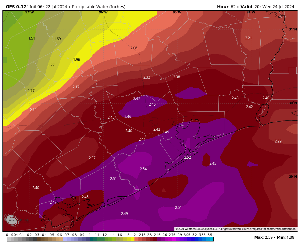
As we discussed on Sunday, the overall setup for this week favors moderate to heavy rainfall, with the potential for some street flooding. The upper Texas coast will lay beneath a trough in the upper atmosphere, and our atmosphere will be laden with moisture. Tuesday and Wednesday look to have the most favorable setups for heavy rainfall, but chances will remain high from now until Thursday.
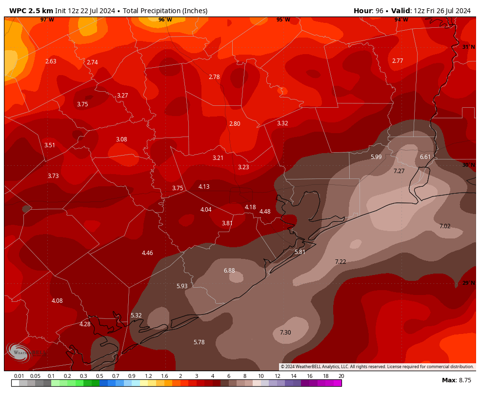
In terms of overall accumulations, I think the Houston area will pick up between 2 and 6 inches of rainfall this week. My biggest concern lies near the coast, with access to the most moisture from the Gulf of Mexico. This is where we could see some bullseyes above 6 inches of rainfall this week. To account for the threat we’ve issued a Stage 1 flood alert for the entire region, which produces street flooding. We’re closely monitoring the situation to determine whether we need to elevate this to a Stage 2 flood alert for coastal counties.

In Houston, roads are designed to flood during heavy rainfall. This is annoying, but in a generally flat region prone to heavy tropical rainfall, roads become arteries by which water is carried into streams and bayous, and thus eventually out into the Gulf of Mexico. So during intense rainfall, roads will briefly back up. This is why we repeatedly stress to not drive into high water. The bottom line is that, this week, we will need to be weather aware. Check the radar before you leave. At this point we don’t anticipate significant home and business flooding, but the heavy rains will likely cause some inconveniences. We’ll be here to try and pinpoint the times of greatest threats. If warranted, we will post multiple updates a day.
Monday
Of the next four days, Monday likely presents the least threat of widespread, heavy rainfall. The chances today actually look best along the coast, from Matagorda to Galveston Bay; and inland, from Montgomery County northward. The most likely scenario is that each of these boundaries remain far enough apart that the central Houston region, including downtown, remains relatively quiet today in terms of rainfall.
However, there is a slight chance the boundaries meet over downtown, near Interstate 10, in which case things would become more active over the central Houston area. Like I said above, keep a good radar app like RadarScope handy. Generally I think things will quiet down this evening and overnight. Highs today will reach about 90 degrees, or so, given the extent of rain-cooled air at your location.
Tuesday and Wednesday
Both of these days should bring waves of moderate to heavy showers through the Houston area. The first of these could arrive some time on Tuesday morning, pushing from south to north, and afterward we should see additional impulses with consistently high atmospheric moisture levels. With mostly cloudy skies, these days should see high temperatures only in the 80s—a remarkable contrast to last year when we were consistently hitting 100 degrees in late July. Overnight lows will be in the mid-70s.
We’ve had some questions about severe weather, and while we can’t rule out some high winds in stronger thunderstorms, generally the wind, hail, and tornado threats will be quite low this week. Our major concern will be heavy rainfall, and rates above 2 inches per hour that can quickly back up streets.
Thursday
We’ll remain in a very wet pattern on Thursday, but forecast models indicate that the impetus for the highest rainfall rates will back off a bit. Regardless, expect widespread showers, with highs in the 80s. At this point we’re planning to expire our Stage 1 flood alert on Thursday night, but we’ll of course be monitoring this closely.
Friday, Saturday, and Sunday
Elevated rain chances will remain through the weekend, but the threat of heavy rainfall should continue to diminish. If you have outdoor plans, I would have a backup plan. Daily rain chances are on the order of 60 or 70 percent, with mostly cloudy skies. Expect highs in the upper 80s to about 90 degrees.
Next week
Rain chances diminish further next week and we’re likely to see a sunnier pattern. As this happens, expect our highs to return to the mid-90s. I don’t mean to terrify or threaten anyone by saying this, but the month that comes after July in Houston is August. And well, August is the worst month of the year as we can expect heat in abundance, and the tropics to become active again after this mid-July lull.

I feel like it always stage 1 or 2 threats. If we ever have stage 3 or higher before the first rain drop falls, we’re probably in big trouble.
The post cleary states “flat region prone to heavier tropical rainfall”, so it should not be surprising to the risks of flooding to occur
*clearly
grammer police, why?
“We don’t expect significant home or business flooding” yet I got 3 feet in my home in Beryl during a Stage 2.
Between the latest misfires and the switch to Accuweather garbage over NWS data, my faith in you guys is all but gone.
See ya….
I can’t go anywhere else so I get to stay in my flooded home, but thanks for the kind response in this trying time?
I’m very sorry you flooded. But to blame Eric and Matt for it is unreasonable.
I’m not blaming anybody just calling out the difference in severity in what is predicted vs what happened. Several bayous overflowed their banks and lives were destroyed, and it was downplayed as “localized impacts” in Stage 2.
I know they didn’t target me or anything, but you come to my house with all my stuff destroyed and you tell me it’s not okay to be angry.
I don’t think Shaken and Stirred was blaming Eric or Matt for his/her flooded home, but the fact is that they and most meteorologists were wrong on their forecasts. Just two days before Beryl made landfall on the coast south/southwest of Houston and moved over Brazoria, Fort Bend and western Harris County, we were told there was a 98% chance Houston wouldn’t see hurricane-force winds or severe flooding. It turned out to be the biggest wind event countywide since Ike in 2008, and 85% of Harris County was without power at one point. Flooding was worse in some places than others, but it wasn’t insignificant. Five or six days earlier, everyone was forecasting Beryl would strike Mexico somewhere south of Brownsville. My view is that predicting the track and intensity of tropical storms and hurricanes is still a very inexact science even with modeling and AI technology. I’ve been paying attention to tropical storms in the Gulf since Audrey in 1957, Carla in ’61, and Camille in ’69. They’re all unpredictable, so plan for the worst and hope for the best. If you live near the coast or along a bayou or creek that regularly floods, have a plan to evacuate farther inland. Do it early so you don’t get in traffic jams as with Rita in 2005, which was another blown forecast, but a favorable one for Houston. Wishing a fast recovery to everyone who suffered during Beryl and the aftermath.
A stage 2 is for “flash flooding with mostly localized impacts” according to their scale. You were one of the unfortunate areas that got that flash flooding that impacted you. The stage 2 alert largely held up for Beryl.
I’m gonna bet you also expect to get that “sticker” MPG every time you drive, too.
Well, that escalated quickly.
Well, we’re past the halfway mark and almost there. In my extremely unreliable prediction, I say about 60 more days left of summer (out of 150 days) before the real cool fronts arrive. Stay in there! Stay focused!
Does “we can expect,” mean the long-range forecast indicates business per usual,, or you’re just throwing that out there as what is “typical?” I know y’all generally shy away from long-range forecasting, so wanted to ask if modeling is looking that way. Thanks!
The pattern this summer seems to be high pressure to our west and the Bermuda high camped off to our east leaving us stuck in the middle with flow coming off the Gulf. If this pattern continues it’s going to get a little spooky around here in August and September when the tropics really get active. My neighborhood in Friendswood still has piles and piles of storm debris from Beryl piled up on our curbs…
That’s an unsettling but apt observation.
Weather and I have now broken up. I’m done. 🫠
This is not 2022 or 23.
The pattern resembles 2021. The death ridges this summer is centered in the intermountain west not over TX. Once in a while the ridge will expand and dry us out and heat us up a bit. Then the dome contracts and opens the door for sensible weather. Summer thunderstorms ,passing showers, Beryl , you get the idea.
Gotta take the good with the bad. Gardens are thriving, it is seasonably hot but not furnace conditions.For the next 7 weeks or until the 1st autumn front, we are vulnerable to the canes.
The “good” thing about summer of 2021 was that we got plenty of rain during June and July, then high pressure finally set up over us in August, protecting us from hurricanes. Hoping for a similar setup for us this time around…
We’re up here in Magnolia. I’ve been watching the radar since about 5am (Wunderground and Ventuski).
I see the line of showers along the coast and they’ve only moved slightly upwards.
.
The showers up north (and the associated front), have been lingering there for hours (a line above Waco to Center), and they are moving slowly to the east.
.
… so yea, I’m not too worried about today (related to the “Montgomery County” comment). We’ll see how it all progresses thru the next few days. Okay, off the HEB.
Grateful for your expertise and thoughtful communications.
Depending on how much rain we see this week, this could end up being one of the wettest if not wettest July’s on record for Matagorda and Brazoria Counties. Parts of both counties have seen over a foot of rain already this month. In July 2007 parts of Matagorda and Brazoria County saw over 20 inches of rain. It looks like we could challenge that record this year.
I have a Samsung Galaxy S23 Ultra running Android 14 One UI 6.1 and when I tap the bell in the lower right corner SCW app it crashes the app and closes.
I was with you until the end, but we all know September is the worst month. You expect August to be hot as heck. September is like…. we were promised fall and given more heat and humidity and when will it end already?? September is painful.
Just to clarify your Stage 1-5 flood alerts, Is this your version of the NWS Flood Watch? Because as of right now there is no Flood Watch for our region as far as I know.
“My biggest concern lies near the coast”. Would Almeda Mall/Hobby area be coastal?
Fix your stage 2 graphic. It’s e.g., not i.e.
Bill gets the Persistence Award 🌟