In brief: Houston has three more modestly warm days before a strong front brings much colder conditions by Saturday night. After that we still have a lot of questions about how cold things will get, and what type of precipitation Houston will see. It could be really messy, or it could be mostly fine.
Winter storm status
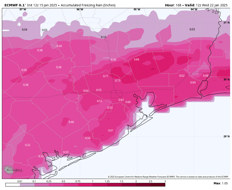
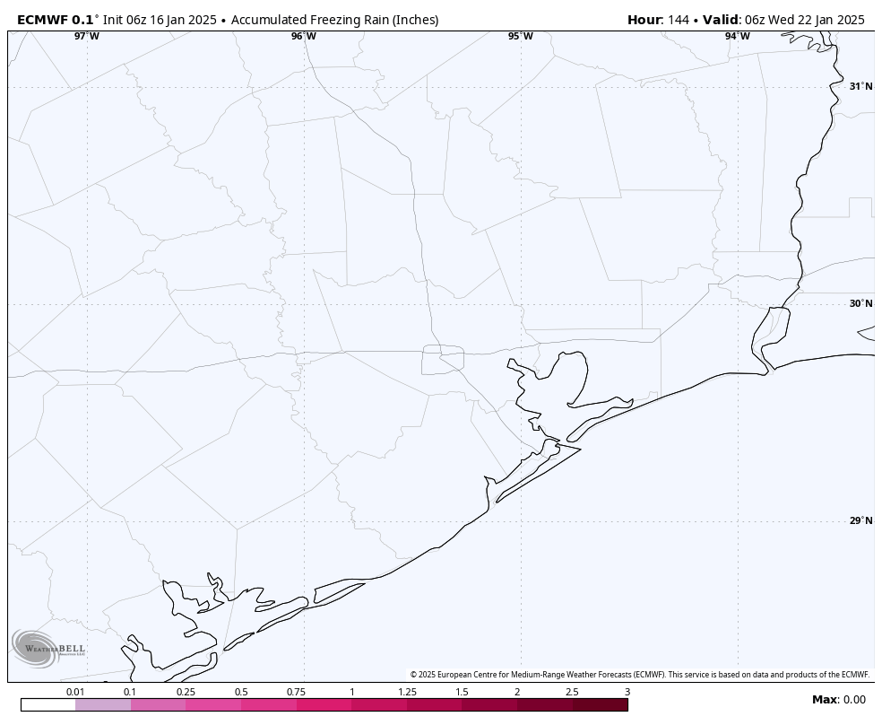
We are continuing to see a distinct lack of consistency in the forecast for next week, both in terms of low temperatures and the potential for snow or other kind of wintry precipitation. To give you an example of this, over the last 24 hours, the highly respected European model has forecast everything from nearly 1 inch of freezing rain, to 2 inches of snow, to nothing in terms of wintry precipitation. So good luck with that.


When we are vague and talk about the ‘potential’ for a winter storm during the period of Monday night and Tuesday of next week, that’s just what we mean. Although your phone may be telling you there will be six inches of snow or some other type of precipitation, just know that this forecast can, and probably will change. Our advice is to continue to be prepared for wintry precipitation early next week, most likely on Monday night and Tuesday, but to understand that it also may not happen. I know the lack of certainty is frustrating, but it’s the reality of the forecast at this time.
We’ve had a lot of questions about electricity as well, and that’s understandable. This will depend on how cold it gets in Texas, and locally, whether we see a lot of ice (which gets on powerlines and can snap them). At this time I’m leaning toward the potential for lower impacts and fewer outages, but again this will depend on how the forecast plays out.
Thursday
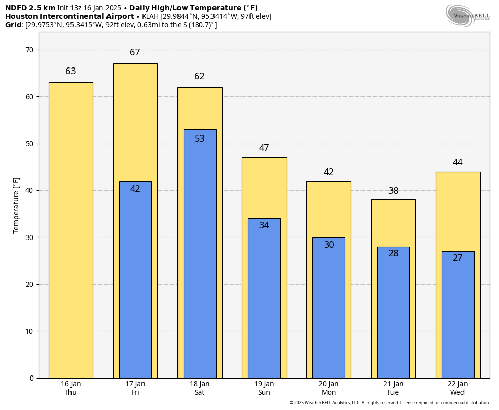
We don’t have any weather concerns today in Houston. Expect high temperatures to reach the lower 60s, with mostly sunny skies, and light winds. Honestly, this is a good candidate for the nicest day of 2025 so far. Low temperatures tonight will drop into the mid-40s, with clear skies.

Friday
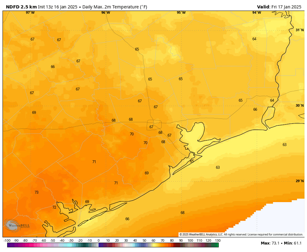
This will be the warmest day for awhile, even as clouds build over the area. Expect highs in the upper 60s to possibly 70 degrees. We’ll also see humidity levels briefly spike up on Friday afternoon and evening. You remember what humidity is, right? Lows on Friday night will only drop into the 50s.
Saturday
Hello, cold front day. The front should arrive some time on Saturday morning, in the form of drier air and stronger northerly winds. However, as skies will be partly to mostly sunny after the front, and the colder air will lag behind a bit, I think high temperatures will still get into the low- to mid-60s for many locations on Saturday. So while this will be a breezy day, it won’t be a particularly cold day. That will change toward evening, however, as colder air arrives with the setting Sun. Lows on Sunday night will drop into the mid-30s in Houston, with the potential for a light freeze for inland areas.
Sunday
For the Houston Marathon, there’s no way to get around this. It’s going to be cold. We’re going to see brisk northerly winds which will, at times, be gusting up to 20 or 25 mph. Start line temperatures will likely be around 34 to 38 degrees in downtown Houston, rising to the lower 40s by late morning. So yeah, a very cold race. By Sunday afternoon temperatures likely will reach the upper 40s. Lows on Sunday night will probably drop to around the freezing level in Houston, give or take, with the coast remaining above freezing and inland areas dropping a few degrees below freezing.
MLK Day
If you’re planning on attending the parades on Monday, or participating in some other activity related to the holiday, please bundle up. Skies will be partly sunny, with high temperatures around 40 degrees. There’s also the potential for a light drizzle on Monday afternoon or evening.
Monday night through Wednesday
This is the likely period of coldest weather in Houston, and when we are most concerned about the potential for freezing weather. The problem is we don’t really know how cold conditions will get in Houston or surrounding areas, and we don’t know precisely how much precipitation will fall, or when. So right now we’re smacking you with a big snowball of uncertainty.

My sense is that temperatures in central Houston will probably fall into a range of 25 to 35 degrees on the mornings of Monday, Tuesday, and Wednesday. That obviously ranges from a borderline hard freeze to non-freezing. (Obviously, the likelihood of a hard freeze is significantly higher for locations such as The Woodlands, and points to the north and northwest of Houston). So if you have sensitive pipes and plants you should be preparing for very cold weather here. But the reality is, we may not get that cold.
As for precipitation, a coastal low pressure system is likely to bring some form of it to the region on Monday night and Tuesday. Because of the uncertainty on temperatures, this could still come in the form of rain, snow, freezing rain, or possibly even sleet although that looks like a lesser possibility. The bottom line is Tuesday morning may be pretty messy on the roads around Houston. Or it could be fine. It may yet be a couple of days before we can say for sure. I want to see some agreement and consistency in the models, and as yet there is none.
Temperatures begin to warm up on Wednesday and Thursday.

Preparing for the worst, hoping for the best. Found about a 9-12″ length of pipe in the attic where critters had borrowed the insulation for their nest, so please be sure to do a check.
Worst might be a couple inches of snow on the roads, especially overpasses, that melts and then turns into a hockey rink overnight.
Parts of Houston could be left in ice-olation
Ice-elation for some…
☺️
Ice-olation….ugh….that one was painful.
As usual, your “Hype-free forecast” is soooo much appreciated…good luck with the marathon…
I don’t know of any other forecasters that can say what u just said. Definitely no forecasters on TV. No one would tune in. People definitely want to know something.
Jeff Lindner. Straight to the point, informative, and low key.
The person I watched on tv this morning said pretty much the same thing this says. Still not sure. Wait and see. Might have snow/frozen precipitation; might not. So, do I cancel my Tuesday morning eye appointment? 🤷🏼🤷🏼
I would reschedule the appointment just to have peace of mind
Check with the doctor. They may not be planning to come in if conditions are unfavorable.
To emphasize the differences in the forecast models, the GFS model shows no temperature below freezing in my location (Santa Fe) during the timeframe discussed. Whereas the ECMWF model shows lows in the low 20s. 🫤
I prefer the Robert Palmer models…
Very clever!
With a ridge of 1040-1050mb I think those lows on models will be trending down as the event gets closer. Like low to mid 20s for your area. By Saturday and especially Sunday models will be clued in.
That’s interesting ☺️
Pipes wrapped and fingers crossed.
This winter is definitely making me want to not have potted plants outside anymore. :/
Agree, like a darn garden nursery in here. So far tho this winter we’re solid 9B hardy zone. I’ll take that as a win!
PS I’ve been reading and adding comments here since the “Tax Day” floods. It’s the only place dedicated to local amateur weather and climate geeks and people who just want to vent on the weather here. It is very self moderated. We’re not twitter. I’ve only seen SCW shut down the comments section a handful of times when someone crossed a line. I’m glad they provide this service (I do support at YE as well). We want weather and climate enthusiasts to keep coming back. The debate and info helps us to THINK. Asking respectfully after scanning below – can we cut back on the snark and repartee just a teeny little bit.
So for those of us with kids, there’s a potential for school closures Tuesday, meaning kids will have a four day weekend, while their parents have a two day weekend…
You would prefer that your kids go to school in dangerous conditions? That the school staff risk their lives if it’s icy and dangerous?
I’m not following your issue here: they’re your kids. If the weather is as bad as some forecasters are predicting, most people won’t be going to work anyway.
Good morning, Nanny. Best not to have children if you are going to worry about them all the time – or buy a big bag of cotton wool and keep them cocooned all their lives.
That’s the answer. Best to let the worker bee sucker middle class pump those kiddos out and keep paying those High taxes and expensive kids. And keep going round and round the hamster wheel, and on your knees worshiping your Master, Lord and Savior…Corporate America.
Now get out there and work for your Master!
This is a weather website, what your rambling about should be posted on a political site
Not sure if you’re replying to me or Pete. My kids are adults. But I still say parents need to take care of their kids. If the weather is bad, it’s not fair to expect other people to take risks coming in to take care of your kids for you.
These days, most jobs require people to work from home during inclement weather, unless the power is out. My vibe from Pete was he was bemoaning the challenge of juggling parenting with work, which I get… I don’t think Pete was suggesting that schools should be open in dangerous weather.
Right. Was also a head’s up to other parents to prepare for that potential hurdle next week, especially divorced dads who might be under the Texas Standard Possession Order, who will have their kids this weekend – already extended for MLK Day – so they don’t get caught off guard!
I don’t know how one could read “You would prefer that your kids go to school in dangerous conditions?” into my post. But some people – maybe a lot of people in this country – are really very hollow inside, constantly needing to create conflict with others just to FEEL SOMETHING, or to fill the void within themselves. I imagine Beth R must be a very lonely person, constantly pushing away all those close to her, with her high-conflict personality…
You’re hilarious, Pete.
What I am is someone who has worked in public schools for 27 years. The number of angry parents we deal with when school is cancelled due to weather is staggering.
That’s quite the emotional visual!
Lol, ignore them Beth. They themselves are the products of the education system.
When I was a kid…….we walked through blizzards to get to school….uphill…both ways… and WE LIKED IT.
Even had to fight off a polar bear with my loose-leaf notebook.
🙂
So can we at least rule out the early doomsday predictions of 6-8 inches of snow?
On the subject of the marathon: Many runners have their names clearly shown on the front of their shirts and as a long time marathon supporter I would highly recommend doing that, so you wearily and despondently slog your way around the course, many will shout out your name and give you a momentary boost to your flagging spirits – it all helps. Good luck, remember, you are supposed to be having fun. 🙂
What are your temperature predictions for the area south of Houston, in particular, Galveston County?
Cool! S/No day…
🌬 ❄❄❄… wait, uh…
mid-30s for the marathon? Gonna have a frozen shutter finger! I’ll see you at mile 26, be sure to smile for the camera!
Unfortunately winter precipitation events are very hard to predict in this area. We pretty much just have to wait and see what happens. That temperature forecast is looking quite a bit warmer than some of the ones I’ve seen lately though.
The graphic posted here at SCW yesterday showing how the layers of cold air at different levels of the atmosphere affect the form of precipitation that could develop helps explain how we might get snow, sleet, rain, etc. and why it is difficult to predict just what we will get. Colder drier air from the north interacting with layers of warm moist air from the gulf interacting are variable, changing, and hard to predict. There have been instances where northern parts of the area got no frozen precipitation because there was no lower warm air layer to provide the moisture but southern areas did.
Stand by for fun. I have graupel on my bingo card.
Agreed 💯
I want snow again. I’ve seen enough sleet and freezing rain these last 5 years. I want to see actual snow flurries. It hasn’t snowed where I lived since December 8th 2017. We are due another snowfall event. ☃️❄️
Yes I definitely know what humidity is and I am enjoying the one month a year we get of cooler less humid weather. I know that in no time we will be thrown back into the sauna for 10 months.
If January ended today, it would go down as the 15th coldest January on record in Houston. Depending on how cold it gets the rest of the month, we could be placed inside the top 10 coldest January this year.
EEEEEEEK !!!! NO cold weather for me! Contribute my share to a worthy cause.
are people really getting paranoid about temperatures in the mid to upper 20s with temperatures above freezing by 10 AM?
PTSD is a hell of a drug.
It sure IS
Yes, because cold weather = no electricity. Pathetic, but that is our reality.
Yes.
An uncertainty snowball. Lovely turn of phrase, thank you.
“We are continuing to see a distinct lack of consistency in the forecast for next week, both in terms of low temperatures and the potential for snow or other kind of wintry precipitation”
So basically your guess is as good as mine lol… alrighty then.
It seems there is not much accuracy on “weathering” these days , there’s always an abundance of caveats, and reality may have it where anyone can proclaim forecasting with a heavy dose of disclaimers. Also seems we point out to the myriad of weather models as the real source of what “may” happen — meaning the models do the projection vs meteorologist? Then, as they say, what’s the point? I imagine go straight to the models, soon enough we will rely on a chart GPT version of looking at weather predictions vs tuning into our local sources. All we can do is cover our plants in am abundance of caution.
Latest GFS is lit ️🔥
It is 2025. Meteorological science enjoys the use of sophisticated computer modeling, satellites, radar, and even supposed artificial intelligence. Yet is unable to predict the chaotic fluctuations of the atmosphere. How amusing! How humbling! And this is not an uncommon occurrence. Indeed, the same thing happened last week as I traveled towards Lubbock. Even a mere 12 hours before the event the weather services were unable to predict exactly where frozen precipitation would occur along a 200 mile line.