Before we get too far into the new year, let’s take a quick look back at 2023. December finished with an average temperature of 57.3 degrees, which was 1.9 degrees above normal for the month. The coldest temperature of the month came on Dec. 11, when the low reached 33 degrees. As I noted last week, Houston did not record a single freeze during the calendar year. It has now been 372 days without a freezing temperature, and counting. We do have a chance at a freeze during the middle of next week, but that remains far from certain.
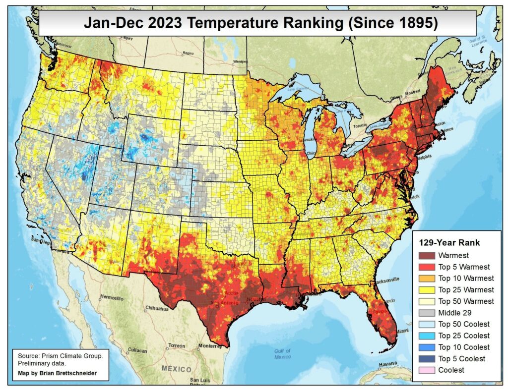
Last year was the warmest one on record in Houston, where meteorological records go back nearly a century and a half. If we look at the continental United States, we can see that large swathes of Texas, and a few other southern states, had their warmest year on record, or at least one of the five warmest on record. With El Niño persisting at least into the spring of this year, I would expect 2024 to rank very highly in terms of temperatures as well for Texas. But with the weather one can never be sure, and so we’ll be here every step of the way.
Tuesday
Rain is coming, but it should hold off for much of today. Skies should be mostly cloudy, with highs only topping out in the mid-50s for most. Winds will come from the east, at about 10 mph. Starting this afternoon we should see a mass of showers congeal to the west of Houston in conjunction with a low pressure system, and this will move through late this afternoon, evening, and during the overnight hours. Accumulations through Tuesday night should be on the order of 0.25 to 1.0 inch for most. With temperatures dropping into the low- to mid-40s it will be a cold and rainy night, but I don’t anticipate any particularly severe weather.
Wednesday
These rains will most likely end during the pre-dawn hours. After a cloudy start we could see some partial clearing of our skies by Wednesday afternoon, with high temperatures likely peaking only in the mid- to upper-50s. Lows on Wednesday night will probably be the coldest of the week, dropping into the upper 30s for inland areas, and low 40s in the urban core of Houston and closer to the coast.
Thursday
This looks to be a fine, sunny winter day with highs in the upper 50s.
Friday
Round two of rainfall arrives on Friday, with another low pressure system driving increased rain chances. The most likely time for rain will be during the daytime, and we likely will also see some thunderstorms. Will they be severe? Right now the overall dynamics do not favor this so much, so perhaps not. But I’ll be keeping an eye on it. In any case, I’d expect accumulations of 0.5 to 2 inches for most areas, so it could be a bit of messay day on the roadways.
Saturday and Sunday
After Friday’s mess clears out, the weekend looks sunny and cool. We’re talking highs of around 60 degrees on Saturday, lows around 40 degrees on Saturday night, and temperatures a bit warmer on Sunday, perhaps in the low 60s. Enjoy.
Next week
The forecast turns a bit fuzzy next week, but the broad outlines are clear. We’re going to see a brief warm-up on Monday, with temperatures in the low-70s, before some rainfall and a front arrives. This should pretty sharply cool things down for Tuesday, and by Wednesday morning we should be quite cold, perhaps even flirting with a freeze.
If you’re running the Houston marathon, our first peek at weather for Sunday, January 14, is necessarily blurry. But the most likely scenario is that some sort of reinforcing front pushes through ahead of the weekend, leading to a cold Sunday, perhaps starting in the 40s, and rising to the 50s. Certainly I can’t rule out rain showers, but at this point there’s no strong signal for it. I like it cold and dry, so this is an ideal forecast for a slow-goer like me. Such a far-out prediction is, of course, very speculative.


At least the winter is turning out glorious so far, compared to the Devil’s mouth which was summer, especially August.
Not sure where to ask this but I am unable to see the right date on my screen. Even when refreshing screen. I thought it would update on Jan1 as that what was showing. Now it is on Dec 27. Can you help?
Just replying to say I’m having the same problem.
This was caused by issues with the National Weather Service’s feed. It should be resolved now.
Was wondering if the “Such a far-out prediction is, of course, very speculative.” was about the cold and dry or the slow-goer? I prefer my 26 miles in a car. Good luck.
I’m also hoping for cold and dry on Marathon Sunday! Best of luck and hope to see you out there!
Thank you for your forecasts. Wonderful to have your I sights on our local weather
As always, thank you for the long range, sneak peak for Marathon weekend! Good luck to you, I know I’m going to need some!!
Do you have a best guess forecast for the NCAA Football Championship game next Monday the 8th at NRG? Game time 6:30. Curious on the timing of the rain leading up to the game dealing with traffic.
Thanks
You might have a better idea of rain chances by this weekend. Today still too early to determine
“On Friday, the most likely time for rain will be during the day and we likely will see some thunderstorms”… I’m glad we’ll get to witness some rain move through here during the day on Friday and if this rain is ahead of a front, maybe we’ll get to see the front arrive during daylight hours. To me it’s been such a long time since this has happened.
I would like an update to the drought situation in the Houston area.