In brief: Houston’s forecast remains more or less the same for the foreseeable future. We’re going to see blistering hot days, sultry and warm nights, and only very low-end rain chances for at least the next week to 10 days. So it goes in high summer in Houston, beneath high pressure.
August countdown
Today is August 15. There are 16 days and 17 hours until September 1.
Thursday
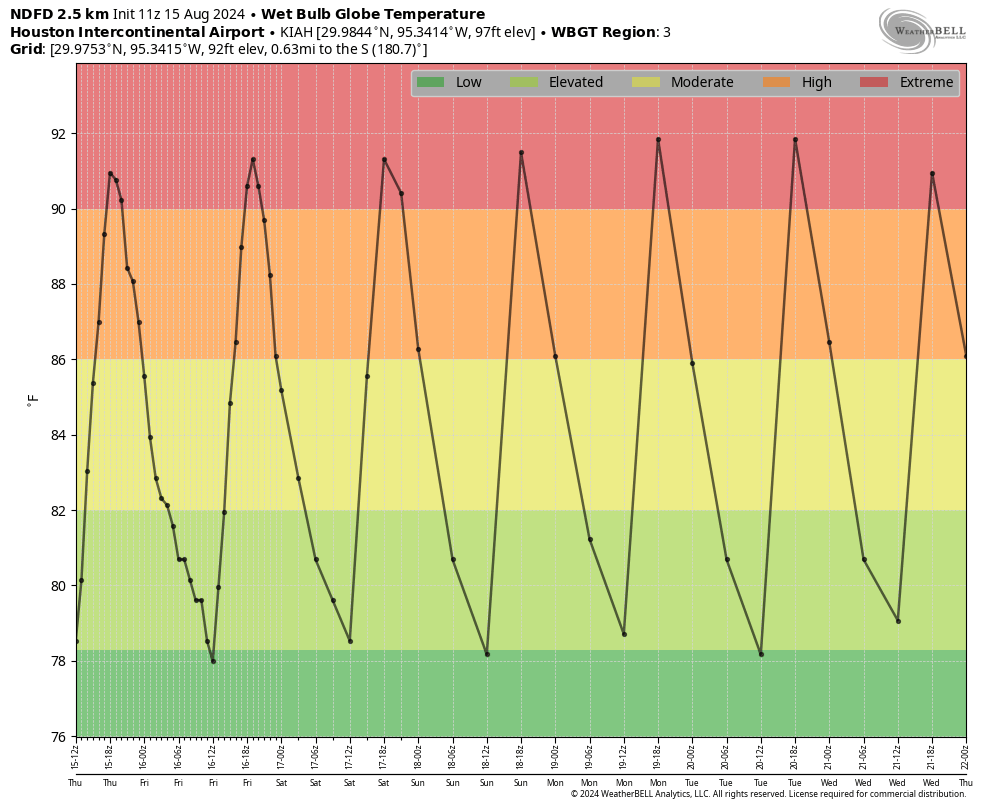
Skies will be mostly sunny today, with temperatures likely reaching the upper 90s for most of the Houston metro area. Winds will be light this morning, increasing to about 10 mph from the south later this afternoon. We will once again be on the lookout for isolated showers and thunderstorms, firing up along the sea breeze, later this morning and into the afternoon hours. Chances will be about 20 percent near the coast, and lesser for locations further inland. Lows tonight will only fall to around 80 degrees.
Friday, Saturday, Sunday, and Monday
It looks like our heat will peak this weekend, and into next week, when much of the city will likely hit triple digit temperatures. We’ll continue to see sunny to mostly sunny skies, with isolated afternoon showers and thunderstorms.
Later next week
It’s still going to be hot. But at some point next week we should start to come down slightly in temperatures, back into the upper 90s. Rain chances could become a bit higher as well, perhaps in the 20 to 30 percent range, during the second half of next week, but I wouldn’t bank on it. The ridge of high pressure just isn’t going to move a whole lot, so accordingly our weather isn’t going to change much.
The tropics
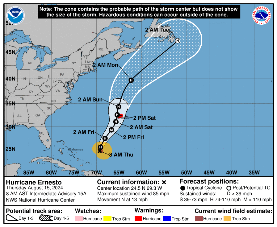
Ernesto has become a hurricane, and it is likely to become a major hurricane before reaching Bermuda this weekend. We have full coverage of this system on The Eyewall. Beyond Ernesto, the Atlantic basin continues to look quiet for the next week or possibly even 10 days. I’m not complaining.

“August” seems not to end in August, but rather about Sept 5/6, when the record highs drop by several degrees.
If Tropics are quiet for the next 10 days, then that only leaves us with Sept and Oct for tropical mischief. I highly doubt we will reach the 25 forecasted named storms.
Thanks for jinxing us 🙁
Don’t dis the weather gods!
Yeah, I’m trying not to get used to the unexpected lull after the harassment of May &.July. I’m grateful, but wary. A long way to go.
A long way to go, and these days the unprecedented seems to happen quite often, anyway..I wouldn’t be surprised if we still find our ourselves watching the tropics, especially Bay of Campeche, in December., or January..
I’ll see your disdain for August and I’ll raise you my hatred of Wisconsin in January and February. I’ll gladly take heat and humidity than feet of snow, 2 hours of sunlight (at least it feels like it) and the potential for stupid cold that you can’t put on enough layers to get warm in.
Yep, been there (Vermont and Michigan winters, actually) and I agree.Also keeping cars running up north is awful.
Do the WeatherBell WBGT forecasts assume full possible solar intensity or do they include a forecast of cloudiness/haziness as it may reduce solar intensity?
As a 66 year resident of Houston, I would rate august 2024 as not bad at all.
It has so far been vastly better than August 2023 which was exceedingly uncomfortable and was totally miserable.
I must agree – also a 66 year (67 pretty soon) resident of the Houston area. Southwest side in the early years, then College Station, then to Seabrook, then to south Cypress, then to W43rd area, then to north Cypress, and now Magnolia. And yea, last year wasn’t an enjoyable Summer. And that very odd Valentine’s Week of Winter of 2021. But that’s what we expect in this area … the unexpected 🙂
Summary forecast – Stinky hot thru Labor Day
Your dedication to slandering August is impressive.
That being said, if high pressure protects us from tropical nonsense, I can tolerate it for longer.
Thanks for everything that y’all do to keep Houston informed!
Just to state the obvious……summer is not over until Sept.21. This means that Oct.5 will be much like June 7 statistically. We’ve got 2 months of pretty hot weather to go, with maybe a cool front or two in late Sept or early Oct. I work outside and hate the hot weather !
Yeah, I think our last 90-degree day on average is October 7th or 10th. Sadly, most years the first half of October is mostly hot and muggy with our first real cold front not arriving until about the 3rd week of October. We got lucky last October but I don’t see that happening this time around.