In brief: Periods of rain and scattered thunderstorms will be with Houston today and tomorrow as a disturbance moves in from the Gulf. Then, we will get another round of heat heading into next week, peaking on Wednesday or Thursday.
Today
The tropical disturbance with 10 percent development odds that we’ve been discussing all week is on final approach to the Texas coast. The NHC pegs it just south of Vermilion Bay in Louisiana. On radar, we’ve clearly got a few showers across the area. There is a more robust area of rain closer to the disturbance itself that’s moving westward over the Gulf.
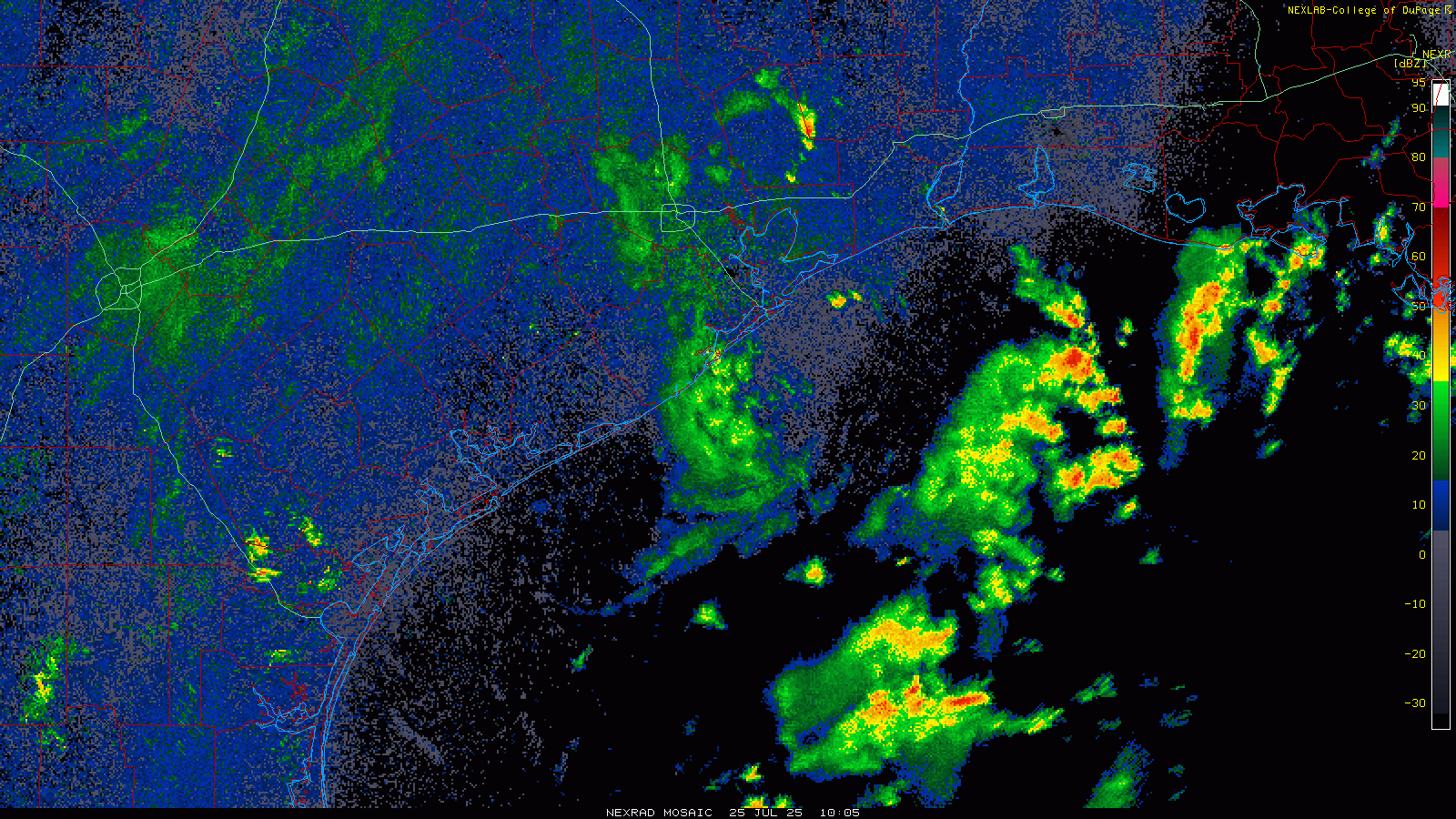
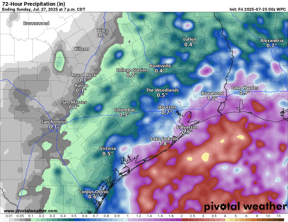
As the day goes on, look for that area of rain to move toward Galveston and/or Freeport. Inland areas will see quick moving downpours at times. Once the disturbance comes ashore tonight, there could be periodic downpours and even some thunder. Some areas will see little to no rainfall. Other places could pick up a quick inch or so in heavier downpours. I do think coastal areas may see a steadier rain later today, and thus they could see up to 2 inches or so of rain before all is said and done.

High temperatures this afternoon will struggle and may not even reach 90 degrees in many spots. Look for upper-80s to low-90s (if the sun gets out) and a bit more humidity than we’ve had this week.
Saturday and Sunday
This tropical disturbance is not slowing down for anyone. By tomorrow afternoon, the fingerprint of the disturbance should be past I-35 and into West Texas. We will still see scattered thunderstorms across the area, with an increase in coverage as temperatures warm up tomorrow.
On Sunday, the chance of rain drops even a bit more, but again not to zero. While Saturday will probably top off in the low-90s, Sunday could be in the low to mid-90s.
Next week
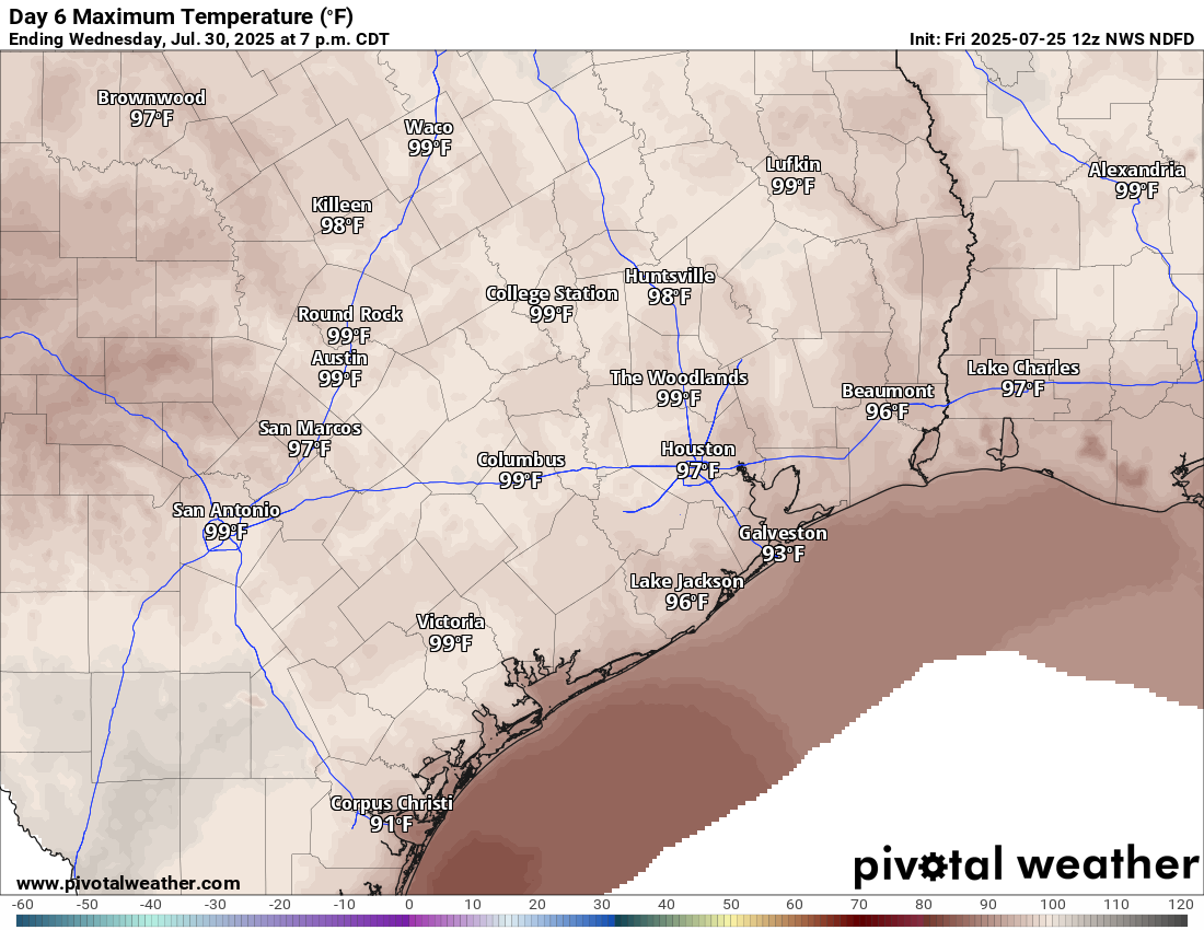
So what’s next? First, we’re going to get a surge in heat once more. Houston should peak in the mid-90s on Monday with a chance of a storm, mid to upper-90s on Tuesday, and upper-90s to near 100 degrees on Wednesday and perhaps Thursday.

After Thursday, it almost looks like yet another Gulf disturbance may enter the picture, though this one could be even a bit farther north (possibly over land) than the current one. No real development risk by any means, but we’ll see if this can’t help enhance shower and thunderstorm chances and lower our temperatures to close out next week.

good morning-wanted to give you a heads up that The Space City app isn’t loading. It launches and shut downs. I have an IOS/apple phone.
Thanks for all your great reporting/forecasting.
Same here for over a week now.
Same happened to me. I deleted the app then reloaded it and that fixed the problem.
Not sure about everyone else, but my area (Memorial) could use a good soaking after a near two-week dry spell. Already seeing the grass crisp up and brown in places.
Wow … I checked NWS Radar page 20 minutes ago – nothing. Yea, there’s been rain on the radar, but the rain blobs have passed under us in Magnolia.
But now, all of a sudden, the rain is coming down pretty good. I’m glad for the rain, but hope it backs off in a bit, because I have a 9am appt in Tomball. And afterwards, will drive across the street to HEB. Anyway, yea, it’s great to get the rain. and of course the side-effect of reducing the temperature !!
Learned about y’all’s page about a month ago and have been reading every day since then – thanks for the great reporting! The 12-year-old in me that wanted to be a meteorologist found a good home here.
We farm in Jackson County, and I can’t help but notice that there’s been an increased chance of rain on those Pivotal forecast maps right smack in the middle of the county every day you’ve put one for the last 3 days. I know we’re not supposed to read too much (at all, really) into the specific areas with little changes or where there are specific cells like this, but I just find it amusing the computers keep showing it like that.
Harvest is nearing close down here so we’d appreciate if it could just back off for a week or so, but we’ll take this over a major storm any day!
Good morning gentlemen,
My SCW app opens then crashes. Any advice? I’ve updated it, it worked a couple of times then back to the momentary opening and crashing.
So how exactly can it be a “Gulf” disturbance if over land?
It originated in the Gulf
I was having trouble seeing the comments earlier. They wouldn’t load. Now it seems to be okay.
Hi @Richard … well known software defect (“bug”), among others.
Report it to “bigdinosaur dot org”.
Richard:
I have this issue frequently with the comments on SCW. Not sure what causes it.
Sometimes I refresh and the comments appear and sometimes I have to check back later.
It’s usually a caching issue — either Cloudflare or your web browser (Safari, Chrome, Edge, etc) is hanging onto a stale version of the page a little longer than they should be. Clearing the local browser cache will often fix it.
Thanks for the responses.
July 25th
Record high: 102 in 1964
Record low: 65 in 1894
I wish the NHC would fix the yellow blob – it should be down more in the Coastal Bend, not up here near Houston.
I’m shocked the yellow blob is still there!
The last time it passed thru (yes, this is the one that circled back around), they removed it at this lingering stage. Seems to be only a rainstorm now, not a “Disturbance”.
I’m excited for this rain. I love it when it rains and its not a hurricane or derecho or what have you.
August: Agree, especially this time of the year. 0.72″ of rain in Jersey Village, more than I expected.
A small orange blob on the radar dumped 0.64″ at our house in Copperfield. Another blob may be headed our way after a while. Welcome rain!
Standing by my motto: double the highest projections. 1-2” or so…yeah, seeing 4” plus in places already.🤦♀️