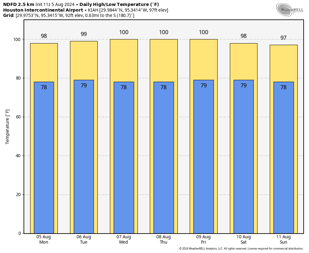
In brief: Congratulations, Houston. We’ve reached the hottest week of the year so far. Many locations in the area will hit 100 degrees for several days this week as sunny skies predominate, with warm and sultry nights. As high pressure backs off, temperatures may start to come down slightly by the weekend.
Peak summer
The first full week of August is, historically, the hottest week of the summer in Houston. At this time of year the Sun still reaches a high angle in the sky (77 degrees), we’re prone to high pressure systems, and there’s no possibility yet of a meaningful cool front. Every day we get deeper into August we lose about 1 minute and 30 seconds of daylight, the Sun is slightly lower in the sky, and start to get on a glide path toward fall. But early August? There is no hope for anything but heat and humidity. And we are going to have plenty of that this week as high pressure dominates.
Monday
Temperatures may not reach 100 degrees today for most of the Houston area, but they’ll be close, in the upper-90s for all locations but the coast. Winds will be light, from the east, at about 5 mph. Skies will be sunny. For areas south of Interstate 10, there’s the barest chance of a shower this afternoon, perhaps 10 percent or so. I mention this only because chances are essentially zero for the rest of the week. Low temperatures tonight are unlikely to fall below 80 degrees for much of the region.
Tuesday to Friday
Most of Houston is likely to hit triple-digit heat during this period. In addition to highs in the vicinity of 100 degrees, each day will see sunny skies, with light westerly winds. Lows will only reach about 80 degrees. Please take heat and sunshine precautions if you’re outside during the middle of the day.
Saturday, Sunday, and next week
At some point the high pressure system firmly in control of our weather this week is going to relent somewhat. That should begin to happen this weekend, but I still expect mostly sunny skies with high temperatures in the upper 90s. A slight chance of rain returns on Sunday, likely in the form of isolated showers along the sea breeze. Most of next week should see slightly cooler temperatures, with highs in mid- to upper-90s and possibly some higher rain chances. We’ll see.
Tropics
Hurricane Debby made landfall in the coastal bend area of Florida this morning, near where Hurricane Idalia did so a year ago. As we’ve been recounting on The Eyewall all weekend, this will not be a messy storm just for Florida, but a very serious inland flooding event for parts of Florida, Georgia, and South Carolina. In Houston we know about the potency of stalling storms and heavy rainfall.
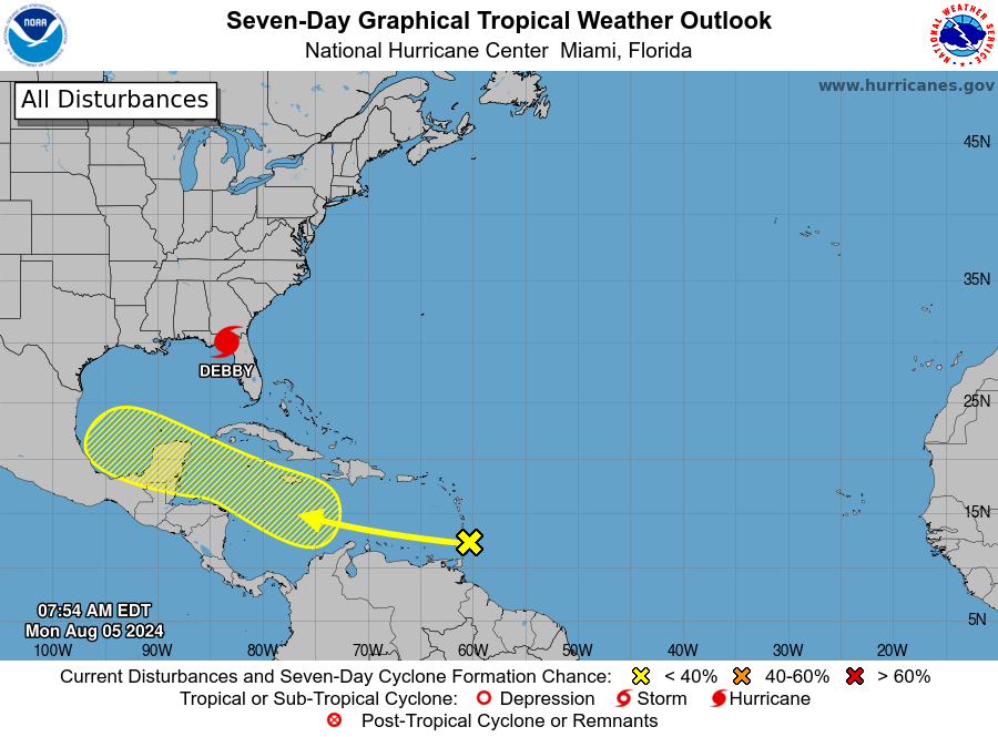
In addition to Debby, there is a tropical wave that is about to enter the Caribbean Sea and should to track more or less due west this week. The global models have been all over the place in regard to what will ultimately happen to this system over the next 10 days. Although it’s conceivable that an organized tropical system could ultimately come to Texas, that is just one of a range of many possibilities. Since it’s August, we’ll need to watch the tropics closely now.

The path of the yellow tropical wave looks suspiciously like Beryl when it was just getting started.
Yeah
(sighing heavily)
UGHHHHHHHH 🙁
Right? Noticed that yesterday when the track had it heading mostly due west across Central America, and my immediate thought was “that’s not gonna last long”, fully expecting more of a west/northwesterly trend trend to develop. We’re still probably 7-10 days from any potential landfall, but my anxiety is already through the roof.
I’ve read some news where it has a low chance of development this week, so clinging on to that for hope/anxiety reduction for now. Hoping best case scenario where it doesn’t get stronger, and just ends up being rain somewhere.
For sure. Just as bad, roughly same path as the “H” storm that shall not be named..
It is likely to change this week but only having to endure one 100 degree day this summer seems like a win when compared to some of our other summers. Last year all but three days in August were above 100 and we topped out at 109 not once but twice. It’s been downright pleasant compared to some of our other summers…
I hope the high pressure hangs around long enough to fend off whatever that tropical wave becomes
I understand the near future…
Heat ridge bakes us in 110+ degree heat index for a week, backing off in time for Cat 4+ Ernesto to hit us on the dirty side in about 2 weeks.
That’s 2024 for you.
And while we’re dealing with the widespread power outages yet again, the heat comes back to bake us alive..And because the city pool season is coming to a close, the public pools won’t be available for us to swim in, during the week, to escape the relentless heat and humidity..
It is my understanding that many city pools have not opened at all this year – or last year – due to a lack of life guards.
Let’s maintain some optimism. Heat ridge bakes us long enough to keep Cat 5 Ernesto away from us and then in mid September we get our first strong cool front of the year and celebrate our first crisp 60 degree morning…
Glenn, this is 2024. Optimism is not warranted.
Can the site owners please ban this doom-and-gloom fan fiction?
Reasonable expectations from recent experience are not fiction. More like being realistic.
We’re being very realistic..It’s not out of the range of possibilities (at this time), to be hit…It’s very early yet, nothing’s EVER written in stone this early..With that said, I’ve seen us be potentially being hit three times, as per gps, in the last 5 days I’ve been looking at models..
It’s about looking at the range of possibilities when tracking the tropics…Hopefully as time marches forward, the range of possibilities really narrows down A LOT, in enough time, that people aren’t scrambling to flee the storm if that’s what they want to do…
In daily life I’m a very optimistic person…Who’s going to hit be hit during the tropical storm season depends on air flow currents, sea temperatures, etc..It doesn’t feel like life is being fair, when we’re hit once a year, or even twice in a summer, but it is what it is…I’m glad we live in an age when information is available to us, to help us prepare, even if the info isn’t what we want to hear…I might not hate hurricane season as much, if we all lived in cities with infrastructure strong enough to withstand winds, floods..And if we all personally lived in hurricane proof homes elevated up from the ground…
except you have people here already saying cat 4/5 storm coming, when it is only a tropical wave… That’s doom and gloom right there
snorting
Exactly.
Not a weather guru, but has anyone seen the latest GFS run? Appears that a Cat2 coming onshore to the Houston area mid/late next week. Time will tell. le sigh.
Yep. The GFS angst radar is up and running
I saw that…
Well, I just looked at the 18Z run and it’s gone. We’ll see on tomorrow’s first run.
GFS as of a few moments ago isn’t showing anything hitting close to Texas. Let’s wait before we get too excited
Nah, I prefer to start panicking early. 🙂
I know, it’s pretty early yet…This year feels different to me, it may only be my imagination ..I feel like we haven’t been seeing widespread model agreements or narrow ranges of predicted outcomes for disturbances in the Atlantic,until a storm is practically in our backyard..Makes it hard to decide what to do unless one ALWAYS stays to ride out a storm…GFS has been all over the place..I’m praying hard that potential Ernesto turns out to be only a tropical depression for somebody who badly needs rain..