In brief: There have been unexpected, and significant changes in the forecast for Tropical Storm Beryl over the last 24 hours. The implications for Houston early next week range from relatively mild to fairly impactful, and we’ve tried to set some expectations in this update. Expect much more from us this weekend as the Houston area now needs to pay closer attention to Beryl.
Houston and Beryl, my how things have changed
Over the last couple of days it seemed like it was within the realm of possibility that Houston might see some direct impacts from Hurricane Beryl, but it was a low-end probability. We wrote as much, and felt as much. But over the last 12 to 24 hours the models have undergone a dramatic shift as Beryl has tracked more north than anticipated, with these subtle changes now having a greater impact downstream. The trends have been universally bad for the upper Texas coast.
Just so you can appreciate this change, here is the shift in what is considered the best global model in the world, the ECMWF, and its forecast for Beryl’s landfall. The first image shows the model’s output at 7pm CT on Thursday, and the other one from 1 pm CT Friday, just 18 hours later.
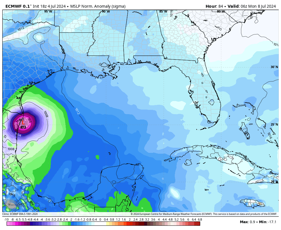
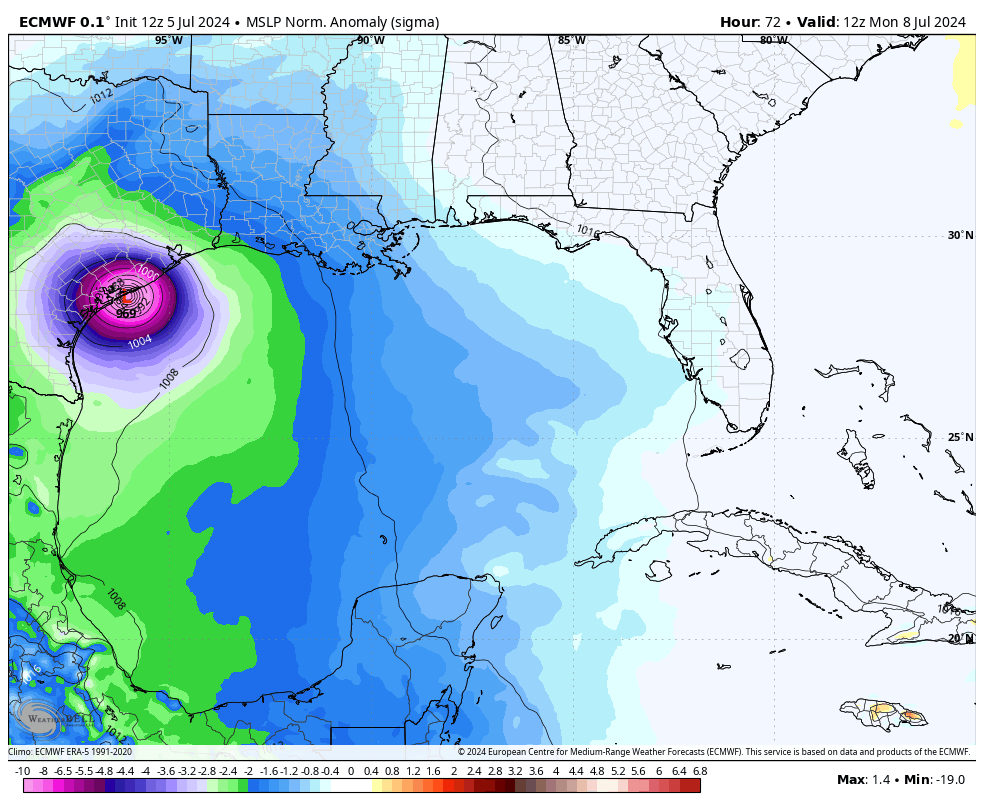
The point here is that the models are still struggling with Hurricane Beryl, even though we are only three days from a final landfall. What once looked like a reasonably confident forecast has now been tossed out of the window. So I want to be clear that what we’re writing now is our best sense of how things will play out, but don’t be surprised if there are further changes. The greater Houston region is now at a significantly greater risk than things looked just a day ago.
Here’s what we know
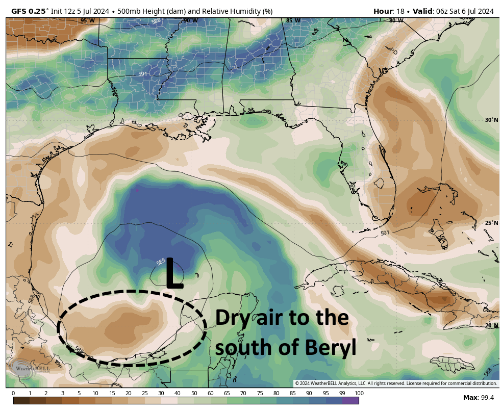
As of this afternoon, Beryl has weakened into a tropical storm with 65-mph winds as it has traversed the northern edge of the Yucatan Peninsula. However it will soon move into the Gulf of Mexico. After Beryl moves back over water it will need some time to reorganize itself. The system is dealing with dry air to its south, and shear being produced by an upper-level low pressure system near South Texas. However, over the course of this weekend, as the system moves to the west-northwest, it should encounter less dry air, and lessening wind shear as the upper level low retreats west. Put simply: by Sunday or so, we should start to see Beryl get better organized, and this trend should continue as it moves toward the Texas coast, with a landfall expected on Monday.
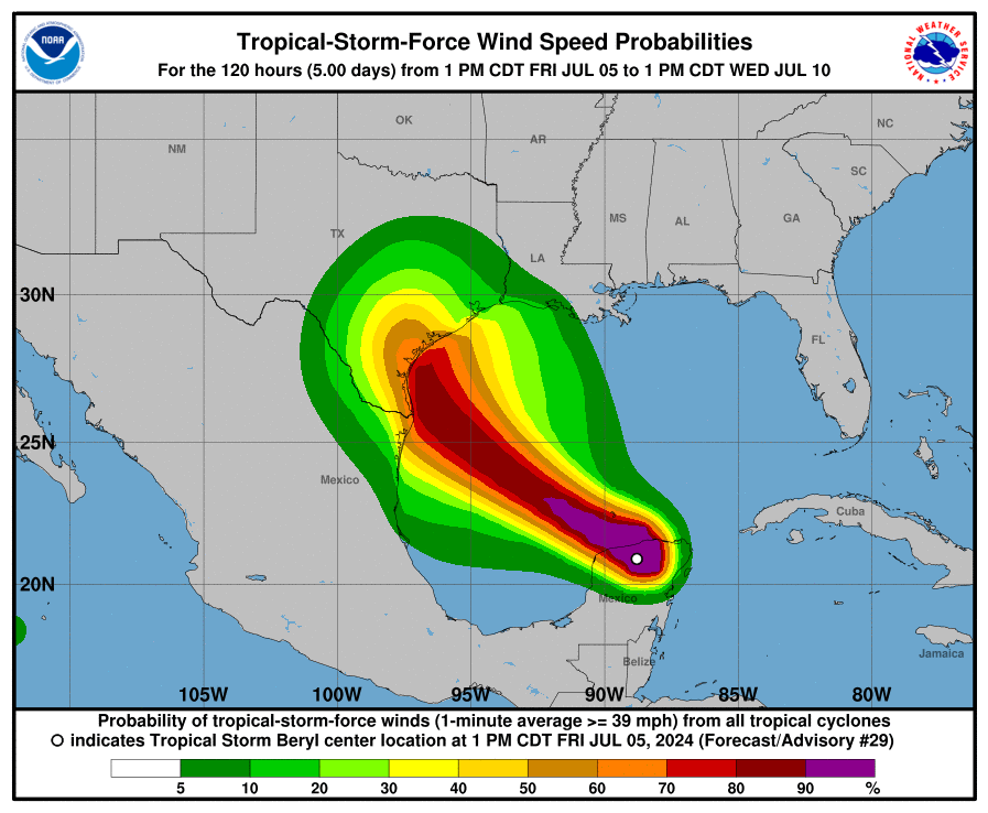
The latest forecast from the National Hurricane Center, issued at 4 pm CT, shows a landfalling Beryl near Corpus Christi in the middle of the day on Monday. As a result of this, the National Hurricane Center has issued a “hurricane watch” for coastal areas from the Rio Grande Valley northward to Sargent, which lies at the northern end of Matagorda Bay (shown in pink, below).
This forecast notably keeps Houston, as well as Brazoria and Galveston counties, out of the hurricane watch area. However, it is entirely possible that the hurricane watch areas move further north, and eventually include Galveston Island. Given the trends we’ve seen over the last 24 hours, all bets are off.
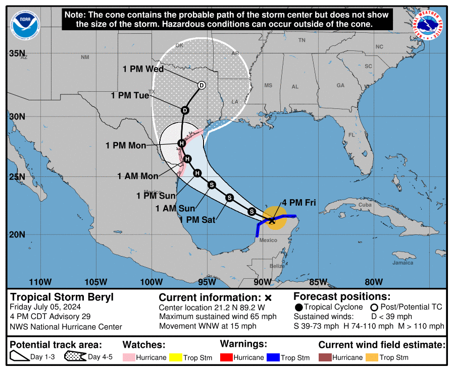
Given the remaining uncertainty, in this forecast post I am going to write about two different scenarios, and the impacts on Houston. In the first scenario, Beryl comes inland along the current forecast track from the National Hurricane Center, shown above. Under the second scenario, we will assume the landfall of a 100-mph hurricane near Sargent, Texas. I consider this a low-end probability, say a one-in-10 chance; and also a reasonable worst case scenario for the Houston area. To recap, the two scenarios are:
OFFICIAL FORECAST: Sourced from the National Hurricane Center, and most likely
SARGENT SCENARIO: Less likely, but more impactful for the greater Houston region
Winds and power losses
Officially, the hurricane center predicts a Category 1 storm, with 90-mph winds, making landfall near Corpus Christi. In the Sargent scenario, we are assuming a modestly stronger storm, a Category 2 hurricane, further up the coast.
Under the official forecast scenario, Galveston Island has about a 1-in-3 chance of seeing sustained winds of tropical storm strength (39 mph), with higher gusts. Chances would be less in Houston, although non-zero. Areas to the west of Houston, including Katy, would have a decent chance of seeing those kinds of winds. Sporadic power outages are likely, although I would not expect to see widespread issues.
With a Sargent landfall, Galveston Island would be almost guaranteed to see tropical storm force winds, and they would be reasonably likely further inland, in places such as Katy and Houston. I think we would see some more widespread power issues, although I’m not envisioning something like half the region being without power.
Please note: In both scenarios the odds of seeing hurricane-force winds in the Houston region would still be quite low, as I expect Beryl to remain a fairly compact storm, with a relatively small area with the strongest winds.
Storm surge
Under the official forecast scenario, tides would run 1 to 3 feet above normal, not dissimilar to what Galveston and other coastal areas along the upper Texas coast experienced during Tropical Storm Alberto. This would not cause significant problems except for very low lying roads near the coast.
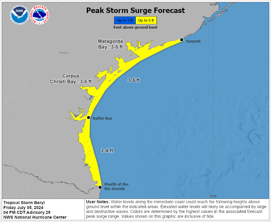
Under the Sargent scenario, storm surge levels would rise 3 to 5 feet above normal along Galveston Island and Galveston Bay, with the most impactful time likely coming at high tide on Monday morning in the Houston region. This still would not be an exceptional surge, but it could be disruptive for coastal areas.
Inland rainfall
Under the official forecast scenario, the greater Houston area is expected to receive 2 to 5 inches of rain next week, with the period of heaviest rainfall occurring from Monday morning through Tuesday night. We would see some higher bullseyes, of course, and probably necessitate us issuing a Stage 1 flood alert. We’ll make a final determination on that on Saturday morning.
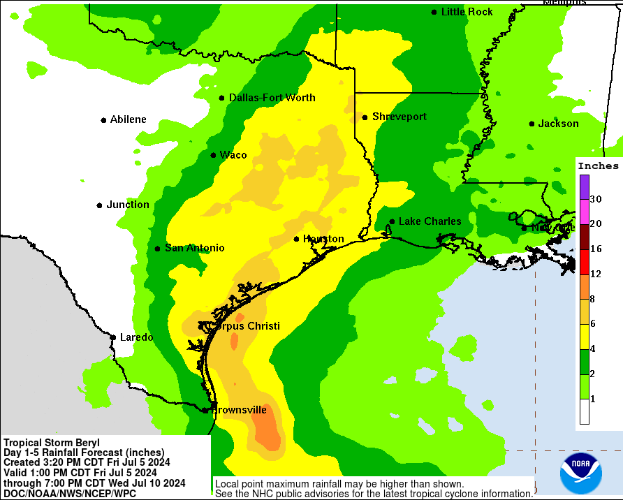
Under the Sargent scenario, the core of heavier rainfall would likely line up more directly over the Houston region, with the potential for widespread totals of 4 to 8 inches of rainfall, and higher bullseyes. This likely would necessitate a Stage 2 flood alert, or possibly higher. Again we’ll make this call on Saturday morning.
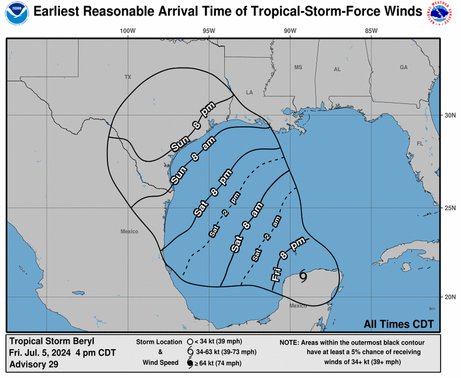
Timing of all this
For the greater Houston area, I don’t anticipate significant disruptions on Saturday or, most likely, all of Sunday. The strongest winds would probably cross our area on Monday, and the heaviest rains on Monday and Tuesday.
We still have a little bit of time to watch this storm and observe trends. However, it is important to pay attention to forecasts over the weekend to better understand how impactful (or not) Beryl will be to the greater Houston area early next week.
Our next forecast will be issued on Saturday morning. We will be watching closely for further track changes, as well as indications that Beryl will rapidly strengthen over the Gulf of Mexico (right now there’s no strong signal for that). Thank you for your patience as we struggle to get a handle on what is proving to be a dynamic forecast.

What kind of odds would you give for Monday being business as usual under either scenario?
Under the official forecast, pretty much business as usual. Under the Sargent forecast, less so in the Houston metro area.
Thank you for the update!
It was bound to happen. On another note, everyone seems to have taken the necessary precautions since it’s being reported that stores are empty of water right now.
Luckily, I got my packs last week.
Goodness. The home faucets still work – just fill up all your buckets, travel mugs, camping coolers, and all of those empty plastic bottles from the last time.
But then I don’t feel like I did anything special to prepare.
Go get your safety ice cream. If the chunks of cookie dough sink, you know the freezer has been out for too long.
I know a lot of people are suddenly experts on meteorology and are critical of you guys. However, most of us are pretty aware that your estimations are rooted in pretty solid evidence and you’re honest about what you don’t know. Your reports are much appreciated.
Thanks Franz. I have a pretty thick skin so I take “someone on the internet is upset with me” pretty much in stride. We can only do the best that we can do.
Wait. I thought you controlled the weather. You mean you dont?
This. Well said.
From Tiki Island…thanks for the update and scenarios. Both as stated are manageable. Any chance it becomes more like Laura and enters at the Texas-Louisiana border?
It’s very difficult to see Beryl turning that far east, but since the storm has defied expectations up until now, who knows? But again, very unlikely.
We’re in Rosharon and concerned about possible flooding since it looks like we will be on the dirty side so wondering if we should evacuate
Thanks guys for the no hype information. It seems the only hype and jump to conclusions is from people in the comments here. If I wanted all the hype, I’d watch the local news LOL
Oh man, I was hoping it would stay closer to Mexico. I’m supposed to fly for the first time on Tuesday and this looks like a bad one
If it’s bad they will cancel the flight and if not you will soon be far enough away that impacts to the flight would be minimal. Likely you just have to keep your seatbelt on a little more than usual. I’m sure it’s more challenging given it is your first flight, but try not to worry. My husband is flying in Monday night and my only concern is cancellation or delay, not safety.
Beryl is certainly proving to be a cantankerous storm. Hoping for the first choice of the landfall further south.
I am a bit perturbed that Centerpoint still doesn’t have their outage map working.
I don’t think Centerpoint is ever bringing back the old outage tracker. They’ll bring something back with less detail and call it “new and improved” (not).
Hi I am flying back to Houston on Saturday, landing before midnight. Any reason to delay my travel till after or concern for potential delays? Thanks
Negative. Landfall would be Monday. 🙂
I don’t think you will have issues in Saturday at all.
Here in San Antonio we’re hoping for this thing to come further west. We could really use the rain.
Thanks as always for your no-nonsense, honest forecasts. We appreciate all you do.
Thank you very much for taking the time to inform us on such pertinent meteorological information. It truly means the world to us, especially in the no-hype aspect of it all. Until I discovered you two, I just kept following those who had the attitude of, “Well, there is going to be a storm tomorrow. WE’RE ALL GOING TO DIE!” Most importantly, I hope you two are staying safe and prepared.
Hey Oingus–the “hype” media haters complaint is getting a bit old. Truth is the northern cone movement was predicted by ABC13 a few days ago, so those of us not afraid of the so-called media “hype” aren’t as surprised as SCW of these “unexpected changes”.
When you watch the radar, does it appear as if the storm is moving nearly directly north of the peninsula? All the forecasts make it look like it’s going to go almost west out of the tip of the peninsula
Thank you. Continuing to follow your forecasts closely.
Thanks for the great info, happy to have you as a resource. Looking at radar and satellite, it looks like Beryl is trying to leave the Yucatan heading straight north. Any possibility it just keeps spinning itself to the east of us?
Yesterday’s NHC discussion said the entire Texas coast was a possibility, and that average error was large at day 3/4, and the storm still had to cross the Yucatan. Yes, the ECMWF shifted a lot but…isn’t that why the NHC looks at more than one model? And I would imagine that the fact the storm was crossing land introduces more error.
I’m just surprised you all are surprised – my layman take was that a shift northward in the track was more likely than not…
Eric and Matt have been looking at multiple models. But until today, the vast majority of those models had this storm entering around Brownsville.
Thanks guys. It looks like AFR HH Aircraft have reported some new developments as far as a possible mid level low forming and Beryl tracking further N and E. I’m sure we’ll get new guidance shortly. Being in GLS with all the tourists…this is getting interesting for sure.
I booked a 7-day stay in Galveston a block off the seawall for checkin tomorrow (Saturday). Looks like I picked the perfect week for a beach vacation! Hahahah!
Why would you spend 7 days in Galveston? I could see a weekend getaway, but if I have 7 days I’m driving to a nicer beach and probably much cheaper too since Galveston is crazy expensive
All there is to see and do in Galveston can be done in about 3 days.
Thank you, Eric, Matt and the SCW team snd your generous sponsor. We truly trust you and are grateful you are willing to be there for us.
If the Eastward shifts continue as they have over the last two days to landfall, is this the Sargent scenario? Or would this be even worse? Also, what informs the estimate that the Sargent scenario is ~1 in 10?
As others have said, thank you for no-hype analysis and for saving the click bait for the local news!
If I have a flight coming into Bush early Monday afternoon, would it be accurate to say my risk for a Beryl-related delay or cancellation is still low at this point?
I just went from a 10 to an 11 on the “I hate Houston” scale.
Lol, you’re funny Adam 😎
Gooodddddd….GOOOODDDDDDDD – I can feel the hate flowing through you – it gives you focus! 🙂
Why are you here? No one is stopping you from leaving.
Supposed to be flying out of Bush at 3:30pm on Tuesday – international flight to Germany.
What are the odds of that still happening? (First ever international flight – not sure how that works? Just a day delay if necessary?)
I will continue to use SCW and the Eyewall as a resource, but sorry, I find headings like “Houston and Beryl, my how things have changed” a bit too cutesy considering that people who questioned the July 1 “nothing to worry about here” were chided like children and trolls for doing so. Like some others, I feel that headline seemed a bit premature, especially on the heels of the missed forecasts earlier this year. It should be ok to express frustration while staying grounded in reality. Please reconsider headlines like nothing to worry about when you already have expressed you can’t pinpoint your forecast several days out. Thank you for allowing the feedback.
This is really SCW’s moment of hubris, the readership isn’t going to let them forget this, especially if damage to Houston is greater than they expect. It would serve them well to make a humble (but not humiliating) apology and a vow to do better.
But I’m not holding my breath.
If there’s damage, significant or otherwise, it’s not due to any forecast accuracy. Stuff is gonna happen, or not, regardless of what anyone prognosticates.
Are you people really taking the service they provide this personally? I’ve never commented here because it’s one of many sources used to gather perspective, nothing more… But the viewership/commenters compared to the last year are ridiculous.
Don’t treat any one site as your source of truth. Take the time to read, compare, understand how forecasts/conclusions are formed and from this use your own brain to make a judgement call. It’s entitled and borderline bullying at this point the expectations of the (hopefully) vocal minority at this point.
Tommy D, I cringed when I read that July 1 headline because I have lived here all my life and seem some pretty unpredictable storms. But I don’t think SCW owes anyone an apology. Eric and Matt do a good job of providing the nuts and bolts of Houston weather in a once a day (normally) format. Detailed information on the track of a Hurricane 7 days from landfall is just a little to much to ask with the tools we have.
Eric and Matt are nothing if not humble, direct, and honest. They owe nobody an apology for forecasting using their best judgment with the information available. They explain daily the uncertainties in the forecast and why changes occur. After big events like this, they always offer a detailed introspective, especially if the forecast differed from reality.
When I agreed with you that day my comment was deleted.
Exactly. Things didn’t “change.” The forecast uncertainty July 1 was huge. It was large July 4. There is a reason the NHC is very cautious about their tracks. If the average error at three days is 100 miles then half the time it will be more.
Do you think there could be significant issues preventing my return from a work trip Tuesday morning into IAH? Nervous to leave my kids now.
Thank you guys for all you do!🙏🏼
Thank you for these updates. Everyone I know reads this and appreciates you.
I’ve been hearing about a possible significant tornado outbreak, but don’t think you’ve touched on that yet. Is that a possibility or is it supposed to occur elsewhere?
Geez, some of these comments are really nasty and inane. SCW is consistently a good source of information. If you want to believe that ABC has a better handle on the weather, go troll them. Fact is, the NHC had this hitting upper Mexico as recently yesterday.
Thank you so much for the explanations and predictions. Any idea what caused the change more north? At this point I am worried about what the Houston area may see! But hoping for the current forecast track. Minimal impacts for all!!
I realize the track (middle of the cone) is going to vary widely, but let me say anyway: the 4PM National Weather Service track had Beryl as a tropical depression crossing highway 290 halfway between Austin and Houston. The 7PM track has Beryl tracking farther to the west, about 3/4 of the way up 290 to Austin (still a tropical depression). The fact that the track stopped moving east, and in fact moved west a little bit, made me happy. I am also happy that I live pretty far away from the coast in the Champions area, in case the “Sargent” scenario occurs.
And hey, if the stores are out of water, the only alternative is to go to Specs!
Eric, given the current models, would it be prudent to take a group of 30+ students by bus to San Antonio on Tuesday early AM?
Do you think there’s a chance that heavy rains or flooding will disrupt travel on Tuesday? I have a pretty important work event and I’m not sure if it’s going to get cancelled.
I’m also supposed to be driving up to Austin on Wednesday morning but I’m hoping it will be out of the way by then.
It looks like the center of circulation is forming/reforming north of where the NHC has it. I think there’s a decent chance we wake up to another model shift eastward…
We have some friends headed out on a cruise on Sunday from Galveston and stops are supposed to include Cozumel and such. What is the likely hood it will be cancelled? Cruise line says it will be fine 😬
Cutting through all the cr*p. Hurricanes are nothing new here. If you have been here a while you should know what to do by now. If you are new to the region then go and talk to your neighbors. It will be fine. Whatever happens. If you have a lawn chair blow over then you can post a funny tweet about the “horrendous damage”. If you lose shingles or sustain any kind of damage you can DEFINTELY count on your neighbors to roll-out and help you like nothing you have ever seen. In this town we help our neighbors and are famous for it. Heed the warnings and just prepare. We have been here 15 years and have been through it all. As a caveat – don’t listen to those neighbors that tell you you don’t need a generator. Go get one as soon as you can if you are able. They are pretty much required purchases down here (don’t forget power cords, power strips and gas cans).
Thanks Eric and Matt! I go straight to y’all for the facts. I look forward to your updates and also understand that weather is ultimately unpredictable, unlike some of these weirdo commenters. Anyways, stay safe everyone! Unfortunately I will be at work either way on Monday so hoping for a business-as-usual day and week.
Latest 10pm update from the NHC shows it went further up, closer to Houston now.
https://www.nhc.noaa.gov/refresh/graphics_at2+shtml/212133.shtml?cone#contents
What an absolutely strange storm. Thank you for the updates and walking through different timelines.
The idea Beryl could hit farther to the north is proving to have merit.
The most likely landfall will be between Corpus Christi and Galveston as a Category 2 on the Saffir-Simpson scale.
The very warm water is a small part of the intensity forecast. A storm turning northward means improved outflow due to the configuration of the trough and the idea this will deepen right up until landfall. There is still a great deal of concern that the German ICONmodel, which has been best with this, will be correct. It has a major hurricane hit on Galveston. It confirms our suspicions and I think NHC, which has shifted northward since yesterday, will continue to do so.
Six days ago this site said “no concerns for Beryl and Texas”. Interesting. Think I’ll stick to reading the ORIGINAL no hype forecasting from the NHC and NWS.
Yep, feel kinda bad I trusted that prediction
Matt and Eric have always given us the same info / resources and maps as the dudes at the National Hurricane Center…The difference is that these guys had to take it on the chin, my impatience and irritation about not having solid details sooner…This is going to be a long summer if the scientific models we have for weather prediction keep initializing wrong on each named storm, making us off kilter on locations of landfall..I think Beryl has had steering currents that have been exceptionally whacky, thus making it difficult to forecast a more precise location, intensity and time of landfall..
And we won’t really know how far off base the predictions for Beryl were or weren’t until this storm has come and gone..My gut says that the scientific computer tools available for the weather experts to use might need to be updated…Updated and programmed to handle our increasingly bizarre rapidly intensifying hurricanes that go around in drunk circles..
People need to know that should they decide to evacuate they need not worry about the grid lock that we suffered during Hurricane Rita… The powers that be learned a hard lesson on that evacuation…I got stuck in bumper to bumper traffic with 11 head of horses trying to get them to Gonzales,Tx…for 17hrs..because the State Troopers were making Everyone go north…. During Hurricane Ike…there were No problems evacuating…but was able to bring back gasoline & ice…for we were without power for almost 2 weeks as well as no cell phone service…
I experienced the gridlock too…On the road for 24 hours, having to hide behind my car to pee..Nowhere to get gas…Thankfully I had a full tank when I started out, so I reached my destination before I needed gas…The Rita evacuation was especially traumatizing and awful..I’m nearing 70 years old, too old to physically deal well with going through another similar experience..