In brief: After Houston set heat records on Tuesday, we should see more of the same today and Thursday. The overall pattern moderates slightly this weekend, but we are looking at mostly sunny and hot weather at least into next week.
Record watch
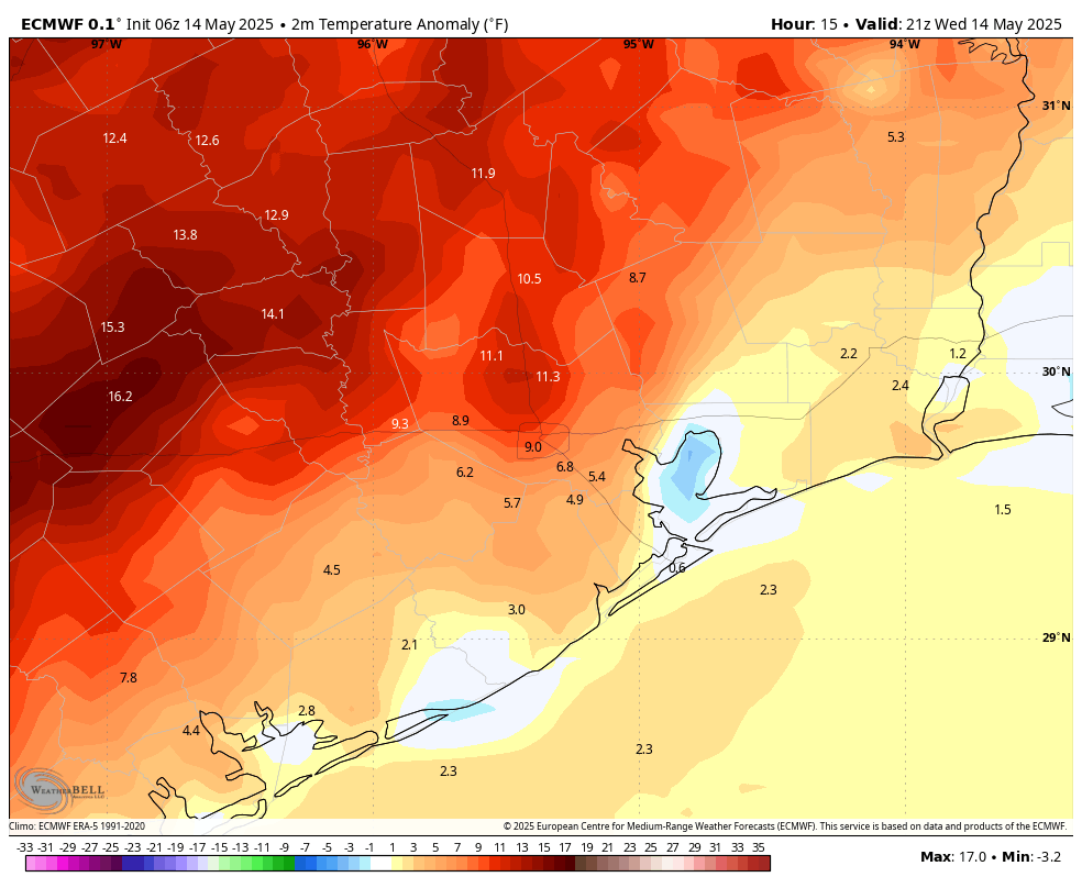
Houston broke its high temperature record on Tuesday, with the mercury reaching 95 degrees. This topped the record of 94 degrees, set in 1907. The city will almost certainly break high temperature records today (93 degrees, set in 2018) and on Thursday (94 degrees, 2018). We then will come close through the weekend, and my tie or break additional records.
This is not particularly where one wants to be in the middle of May, with at least four months of summer ahead. But here we are. Matt and I are working on a summer preview, which we will publish in a couple of days. I don’t want to spoil anything, but I don’t think there will be any surprises. This high pressure pattern currently in place, known as an Omega block, can be fairly persistent. And seeing one at this time of year is not a good sign.
Wednesday and Thursday
The setup favors maximum heating today and Thursday, so we can expect the urban core of Houston to hit at least the mid-90s. Areas north and west of the city will be hotter, and we can’t entirely rule out a few isolated readings of 100 degrees. Areas closer to the coast should be a bit cooler, in the upper 80s to lower 90s. Conditions will be breezy, with sustained winds of 10 to 15 mph, and gusts up to 25 mph. Skies will be mostly sunny during the daytime, with some clouds building in during the evenings and overnight. Lows will only drop into the mid- or upper-70s, so it will definitely feel muggy outside.
Friday, Saturday, and Sunday
Daily high temperatures may back off a couple of degrees this weekend, but it is still going to be sizzling for mid-May, feeling more like late June or July out there. It’s also worth noting that we are about one month away from the Sun reaching its highest point in the sky, so your skin will burn quickly. Please take precautions for prolonged Sun exposure. And we are going to see a lot of sunshine this weekend, with rain chances hovering around zero.
Next week
When we get in pressure patterns like this, it becomes a waiting game to see when it will break. At this point, I think the earliest likelihood of this is next Wednesday or Thursday, when rain chances and somewhat more moderate temperatures may return. But there certainly are no guarantees.

What does the temp being so hot this early do to the hurricane season this summer?
I guess if there’s a ridge over us during while a hurricane forms, it’d knock the hurricane elsewhere.
Likely it will just make the Gulf even hotter, as its presence is just another indicator of a warming planet.
Maybe we’ll get lucky & get one as a shield at just the right time?
It’s called “May in Houston”.
Yeah, May in Houston isn’t typically mid to upper 90s with lows near 80 for 10 days in a row with no relief. This isn’t even normal for June, let alone May.
Omega blocks are the Trough, Ridge, Trough setup that forms the letter Omega on maps. We get the ridge part of course.
Is this temporary, or is this day two of a 4 and 1/2 month death ridge regime?
The plot thickens, just like the outside air.
Definitely thickening air gross
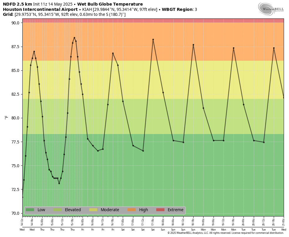
Not a great sign when you’re breaking out the WBGT graphics in mid May!
Every day for the next 8 days will likely tie or break record highs. And sadly, most of these records were set not that long ago. There is no way to deny what is happening anymore. The science is settled. This is our climate now, folks. Get used to it. The dog days of summer are starting earlier and lasting longer than ever before. And the best part is that it will only get worse in the future. In ten years, we will probably start seeing persistent heat like this starting in mid-April and lasting until mid-November.
Is lol the only thing floating in that empty cranium of yours? Can’t wait til the boomers all die so we can fix the mess you created with your greed and vanity.
We get it, you believe in climate change. Not sure you need to make the same comment here every time it’s hot outside. “In ten years…” weren’t the polar ice caps supposed to have melted by now causing catastrophic flooding in coastal cities too?
Nope that’s not what any actual climate scientists have ever said.
It takes less than a minute to search on google for what actual climate scientists say… and that’s exactly what they say (Scripps Institute for Oceanography seems like a reputable source).
Meanwhile, climate change advocates take private jets from their coastal estates (because they aren’t actually concerned about sea levels rising). Climate change fear mongering a joke and I feel bad for those that continue to fall for it.
I’m not sure what article you read, but I just did a Google search, and it says that no coastal city is expected to be completely underwater in the coming decades; However, by 2050 sea levels will likely have risen by 0.3 meters, which will lead to coastal areas being more prone to tidal flooding from hurricanes and certain low line areas will go completely underwater. This is already happening in some places in Louisiana and Florida. There is a lot of overdramatic fear-mongering about climate change by certain politicians and the media. I am right there with you on that one. I hate it because it takes away credibility from something that truly is a growing problem that will worsen in the future. It’s not an overnight threat, so many people naturally ignore it or disregard it, especially when there are many overdramatic articles about climate change. It has already been a bad enough issue without blowing it out of proportion in scare adds.
climate change. From article, “This topped the record of 94 degrees, set in 1907.”
That’s 118 years. Just an odd anomaly.
Yes but heat records are being tied and broken much more often than they ever did before and not just in urban heat island cities either. And many of the records we keep breaking were set not very long ago which demonstrates even more the warming trend our climate is facing. There was always heat anomalies in the distant past but the heatwaves back then happened less frequently and didn’t last as long as they do now.
You are being a little dramatic. We are not likely to tie or break record highs for the next 8 days. After today it moderates likely just below record levels. In 2021 we did not even have one 100 degree day so I’m not sure I agree that “this is our climate now”.
Yeah but in 2021 the Pacific Northwest experienced record shattering heatwave in late June to early July with temperatures reaching the 110s. Even Canada was severely impacted by this heatwave. Global warming doesn’t mean that every region on Earth is going to get hotter and hotter every year. There will still be cool periods here and there. Global Warming means that the average trend in temperatures will continue to rise more and more across most regions on Earth. This leads to the more frequent and longer lasting heatwaves that have been happening all over Earth.
We were stuck under a persistent upper level low during the summer of 2021. Clouds and frequent rain was the only reason that summer was mild. But keep in mind since 2010 Houston had its hottest summer on record twice and it’s warmest winter on record. We’ve also had the warmest February, June, July, August, and September since 2017. So one coolish summer doesn’t overturn the rapid warming trend we are on.
In our history we have had plenty of heat waves. I don’t think it is wise to blame every warm spell on man made climate change. We are in an interglacial period so some of the warming is likely due to natural cycles and some of it is due to the urban heat island effect. The world’s population has been forecast to peak sometime around 2080 so around that time or even sooner we should reach a peak in our consumption of fossil fuels as well.
I agree not every hot spell is outright caused by man made global warming, but the effects of man made global warming is adding a few extra degrees to most heatwaves now. For example, the intense heat most of Texas is experiencing right now is caused by dry desert southwest winds wrapping around a low pressure system to our north. However, the baseline temperatures of the tropics are a few degrees warmer than they normally would be without the influence of our added greenhouse gasses. This is adding a few extra degrees to what already would have been a very hot day naturally.
The Gulf is also significantly warmer than it normally would be this time of year which is increasing the dew points, making the heat more dangerous with higher wet bulb temperatures. It’s honestly basic, simple science. I do not mean that in an insulting way.
When did you swap “global warming” for “climate change”? You personally I mean. When you were told to?
They both mean the same thing. Global warming causes climate change because of its effects on the jet stream, rainfall patterns, and the environments that are experiencing a warmer climate than before. Are we ready to graduate to the first grade yet? Asking for a friend
It’s hard to argue with fanatics, CChange Their brains are stuck in concrete thinking – only they themselves can actually pick up a science book and try to learn. What’s sad is they are experiencing climate change firsthand, yet they’re so wed to their opinions that they refuse to acknowledge obvious facts out of a desperate attempt at egoic self-preservation.
Don’t let it bother you so much.
Is there an explanation as to why Galveston is no part of this heat wave? They are just 50 miles SE of houston with highs of 85 or so all week.
Being next to the Gulf of Mexico moderates the temps.
Water temps along the coast are only in the upper 70s. With the onshore flow in place, Galveston gets a slight cooling effect from this.
Good Morning!! Why is galveston not on the Heat Wave? Thank You!!
Galveston is receiving the small benefit of being on the coast where the Gulf is moderating the temperature.The Houston area is not dead center of this heat wave, it’s Central Texas.
Look at San Antonio and Austin, the residents there are going to spontaneously combust, you’ll see it on the 6:00 news.
I was loosely following temperatures at the three TV stations and my own thermometer here in the SW burbs and only saw the temps hit 91. Sure didn’t feel like 95 when I was out yesterday afternoon. Maybe Bush has it’s own little heat dome.
Yesterday did not feel as bad but we had these situations back in the 90s and other yrs of course since I been living here. This is nothing new. If we broke a record since they are telling us since 1907 hell the weather back then also has its changes. The world has its natural cycles we notice it more due to how fast we get news out to everyone. Climate changes naturally all the time.
It is definitely new to have 10 days in a row of mid to upper 90s in mid May in Houston. And yes the climate has always changed naturally on Earth but the changes we are seeing today are not natural. The natural changes in the past took thousands of years to occur not a few decades. The frequency and severity of heatwaves have been increasing drastically over the past 10 years. But I understand no amount of evidence will ever convince people who choose to stick their head in the sand and pretend that nothing is happening when more and more people and animals continue to perish from weeks upon weeks of brutally hot temperatures in climate zones that are not used to it or have the infrastructure to handle it.
You guys better appreciate dew points being in the 70s and not 80s like last year.
Sadly the dew points will probably will be in the 80s later this month.
Today – Sunny, with a high near 96. South wind 5 to 10 mph increasing to 10 to 15 mph in the afternoon. Winds could gust as high as 30 mph.
Tonight – Increasing clouds, with a low around 75. South wind 10 to 15 mph, with gusts as high as 25 mph.
The only good news I can see is it is T-minus (about) 2 years and counting before I don’t have to worry about this crappy Gulf Coast weather and hurricanes anymore. I won’t be here. It will be good to see snow 2 or 3 times a year instead.
Where you moving to Blackhawks?
I’m moving back to North Carolina in about a month. 6 years of hellish summers (plus quarterly natural disasters/plant explosions) has been quite enough!
NC is one possible destination. Somewhere along that latitude. As long as it is 200+ miles from an ocean or gulf.
Is this Omega going to create a flood somewhere?
I’m not 100% sure Matt J, but I think it already has flooded from the Omega. The mid Atlantic region, particularly Virginia and Maryland have just had catastrophic flooding. A 12 year old boy near Charlottesville lost his life from the flooding.
My reply is not posting. To Matt J: I think it already has in the mid Atlantic region, particularly catastrophic flooding in Virginia and Maryland. A 12 year old boy lost his life from the flooding.
Not exactly a bust, but San Antonio only Reached 102 degrees instead of the anticipated 105/106, Houston’s forecast was right on the nose for Bush at 96, but a little low for hobby at 93.
Just scanned down to here. These posts are hilarious! Good update. As you say it’s been a dry heat. Felt pretty springlike to me. Def not July August.
Even though it was uncomfortably hot where I live in Brazoria County today, the contant breeze helped tremendously and I am still enjoying the benefits of the realitvely cooler Gulf waters down here.
You are definitely correct it was not near the intensity of the average July or August afternoon. The max heat index where I live today was 95 instead of 101 to 103 like it is during the average summer afternoon