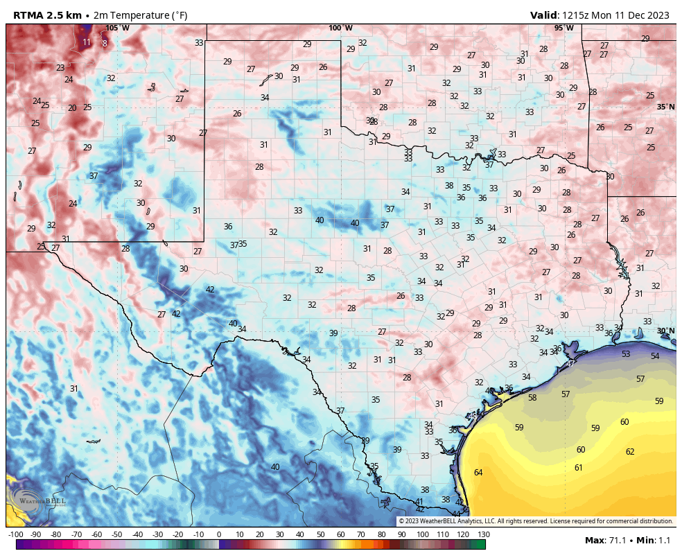
Good morning. And it’s a chilly one, with temperatures in the 30s across the entire metro area away from the immediate coast. Some locations, such as Conroe and Cleveland, are even experiencing a light freeze. Our weather will now turn warmer, with daily high temperatures that should more or less remain in the 60s for the foreseeable future. Other things covered in today’s post: the potential for rainfall on Friday and Saturday of this week, and our first Christmas Day forecast below.
Monday
For anyone getting going this morning, it’s a cold start. However, at least those winds are light, as as they’re coming from the east we’re going to see a warmer flow today. With sunny skies we can expect high temperatures to climb into the low 60s. Low temperatures tonight will be more moderate, generally dropping into the 40s for Houston, with slightly cooler conditions for outlying areas.
Tuesday, Wednesday, and Thursday
With high pressure off to our east, we can expect a generally easterly flow for the middle of this week. What does that mean? Tuesday will start out mostly sunny, but we’ll see increasing cloud cover through Wednesday and Thursday. Highs each day will be in the 60s, although there will be some variation depending on cloud cover during the afternoon hours. Overnight lows will generally drop into the low 50s. So all in all, pretty moderate weather for December. One thing to note: If you live on the coast, tides will be higher than normal due to the persistent easterly winds.
Friday and Saturday
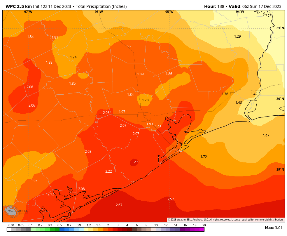
We’re going to see a favorable setup for rainfall this weekend as an approaching front combines with a reasonably moist atmosphere. The details are still a bit hazy, but Friday will be mostly cloudy, with a modest chance of showers in the morning, and higher odds during the afternoon and overnight hours. The front itself should move through Friday night, at some point. But it won’t immediately scour all of the moisture out of the atmosphere, so some light, lingering showers will be possible during the day on Saturday. All told I expect the region to pick up 1 to 3 inches of rain through Saturday night. Highs on Friday will be in the 60s, and on Saturday likely in the 50s.
Next week
Sunday, at this point, looks to be partly to mostly sunny, with highs in the low 60s. So that’s probably the best day for outdoor activities this weekend, if you can swing it. I’d expect to see partly sunny skies and highs in the 60s through at least the middle of next week, with low to non-existent rain chances. Nights will be chilly, mostly in the 40s.
Christmas Day forecast
We’re still 14 days out from the Christmas holiday, so a specific weather forecast is necessarily going to be stuffed with caveats like a stocking. It looks like we’ll continue to see fairly chilly nights through the middle of next week. By around Dec. 21, however, we should start to warm up. So what happens after that? Understandably, there is not a strong signal in the models right now, but if anything they’re leaning toward slightly warmer weather through Christmas Day, with highs perhaps in the upper 60s to lower 70s. At this point we absolutely cannot rule out significant rainfall, but there’s no real signal for strong showers.


It would be nice for once to have a normal winter where temperatures drop and stay there for three months.
At least I’m enjoying this morning in the 30’s.
You can’t always get what you want
So, not sure if you’re new here or not. But that’s kind of how SE Texas winters work. Always has. Always will. Feel free to move North though.
Ahhh, another transplant that didn’t do their research of this dismal region. Hoping to 80 degree beautiful Christmas Day coming ‘round the corner
80°F+ winter high temps are not my ideal, but I do prefer them over 30s lows like this morning. Low 70s highs and mid/upper 50s lows seems to be sweetspot.
It dropped down to 30 in parts of Brazoria County. The birdbath was frozen on the top layer. 1st freeze of the season for my area.
But 30°F seems too light a freeze for that to happen…
It was at and below the freezing mark for 6 hours where I live. That is plenty enough time even with just 30 degrees to freeze the top layer of the birdbath. Anything at or below 32 can freeze water given enough time. I also have the birdbath exposed to the clear night sky. The background of space cools objects on the ground even faster than the air.
Awww. Hope it trends colder as we get closer to the day.
Still hope for no harsh freeze, the trees already look scrounged enough.
IAH still has a chance to escape the year without a freeze. Lowest this morning was a near miss at 33°F.
Are the mosquitoes dead yet?
It always ends up being a warm Christmas when it’s cool like this in the weeks before. I would love a white Christmas, but alas I live in South Texas so I’ll enjoy the cool while it’s here.
I don’t think the “miracle” white Christmas we had in 2004 will ever happen again in our lifetime, but you never know lol
🌬 ☁️ ⛈ 🌨 ⛈ ☁️
What a relief from the simmer/summer.
I want to feel the cozy of December ❄
The chill & the warmth 🧸
See the lights 🎄
Make homemade chicken soup 🥣
Offer love and health to All 💓
Thank you SCW for all you do ⚘
“All told I expect the region to pick up 1 to 3 inches of rain through Saturday night”
Given the usual experience around here, this probably means we may – if we are lucky – get 1/3″ of rain.
Ain’t that the truth!
Exactly. El Niño? Ain’t no El Niño going on. Look at the gulf coast drought map.
Houston is just perpetually CAPped these days. Doesn’t matter the season or the weather pattern anywhere else. We just have an atmospheric cap 24/7
Well, as usual the front we’d been looking forward to didn’t arrive here where we live until Saturday evening. It was then around 6:00 that evening when I began monitoring the local radar where I could see a line of rain headed this way. There was lightning with very heavy rain. But just before the leading edge of the storm reached highway 1764, all he heavy rain and lightning completely vanished. We did eventually have a nice north wind, but bottom line was the fact that all this happened during the night Saturday.
Now they’re saying that our next front is scheduled to move through on Friday night. It’s honestly hard for me to remember the last time we got a really good cold-front in here during the day. In years past I always used to love watching the weather change first hand. Maybe watch a line of black clouds approach before witnessing the treetops bow down as the first line of strong northerly winds rushed in.
Even without the freeze, frost events can still occur/pose issue on specific surfaces (depending on where vegetation is) at the 33-37°F air temp range.