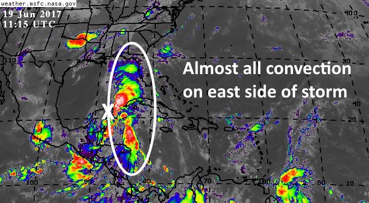
The heat is on for Houston. Sunday’s official high temperature reached 96 degrees, and we’re going to have a couple of more days in the mid-90s, with isolated to scattered showers and thunderstorms, before our weather may change significantly by Wednesday due to a tropical system. Or not. Here’s the latest on what we know about Invest 93L, the system moving toward the southern Gulf of Mexico.
Organization
The storm remains very large and disorganized, producing fairly heavy rains on its eastern side. The best estimate as of Monday morning is that its center is now moving across the northern tip of the Yucatan Peninsula, and will emerge into the southern Gulf of Mexico later today.

A hurricane hunter is scheduled to investigate the system this afternoon to better characterize its organization, and the National Hurricane Center still rates it as a 90 percent chance of becoming a tropical depression or storm this week.. But as we’ve been suggesting, it’s unlikely to find overly favorable conditions to strengthen in the Gulf of Mexico, so the primary threat from the system will be heavy rains.
Track
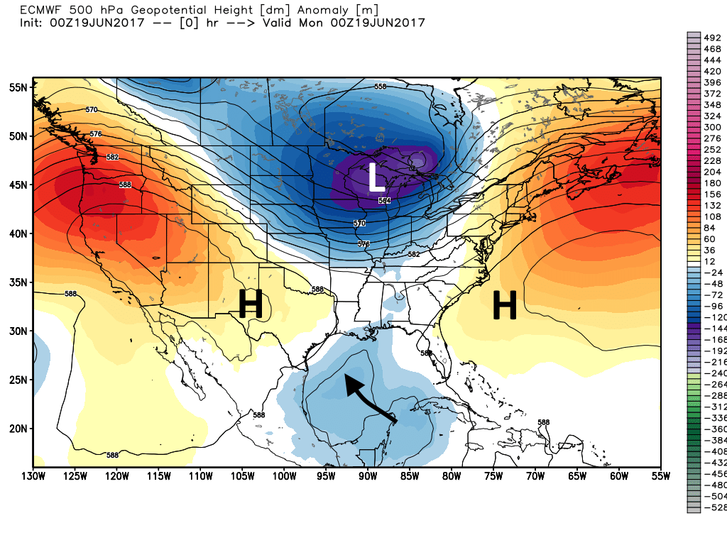
Before we get too deep into the likely track for Invest 93L I wanted to take a moment to explain why the global models have been struggling to get a handle on this system over the last few days. There are three major patterns in the mid- and upper-levels of the atmosphere that will guide the storm this week, including a high pressure system over the western United States, a large trough of low pressure over the Great Lakes area, and high pressure over the southwestern Atlantic Ocean (see map below). The models must correctly predict the evolution of all three to determine the track of the tropical system.

It does seem as though we’re finally seeing some better agreement on what is likely to happen. The models generally agree that Invest 93L will move toward Texas or Louisiana this week, and likely make “landfall” in one of those two states by around Thursday morning.
What’s important to remember is that nearly all of the rainfall associated with this tropical system is located on the right, or east side of the system. It will likely lead to a significant rain and flooding event somewhere on the Gulf coast. So if it comes ashore in Galveston, Louisiana is going to get drenched, but Houston isn’t going to see much rainfall. If it comes in further down the Texas coast, near Corpus Christi, then Houston could see 4 to 8 inches of rain, with tides a few feet higher than normal.
So here’s your forecast: We’re either going to be very dry or very wet during the second half of the work week. I’m sorry, it’s all dependent upon the track of this system, and we’re not going to have a good handle on that for another day or so, if and when 93L becomes better organized and develops a tighter center of circulation.
Posted at 7am CT on Monday by Eric
I love the way you report! Thank you for sharing honestly and letting us know why things aren’t always clear cut when it comes to the weather. I’ve learned a lot about how the weather works just by reading your posts.
Thank you, Ann-Marie.
Followed your posts religiously on the chron site. Love that we have this platform to continue reading your weather insight. Keep up the great work.
Thank you to Reliant Energy for sponsoring this blog. I read it every day. Very comforting to have during the hurricane season.
We will be vacationingin Orlando and Cape Canaveral starting tomorrow. How much rain is Florida likely to receive if this scenario plays out? Thanks for your great reporting as always.
We are going to Bastrop to a resort on Weds. Will it affect our travel? Most of our planned activities are outdoor so I would hate to go and be stuck indoors all day.
Yes, Eric!!! You are the only weather predictor that tells the truth….I have finally quit even watching the newsy TV weather people. Thanks!!!
Two questions: Any comments on the second system in the Eastern Caribbean that appears to be in the pocket for a Gulf of Mexico entrance?
The spaghetti maps on Fox Hurricane website show the system going into La. with no track west of Houston. They have seemed to move to the West overnight. Are you more inclined to predict a landfall East of Houston?
The system near the Eastern Caribbean is likely to die from wind shear this week, so I’m largely ignoring it for now.
For now many of the models are well east of Houston. But the most important model, the European, is showing south Texas.
When do you think a more accurate forecast will happen? After the hunters are in and out or just time?
Thank you
Hurricane hunters will help, definitely. That should give us some better data for the 00z and beyond.
Best weather reporting for our region – thanks for the updates.
I never followed Eric to here after he left the Chronicle, until this week. So I’ve probably missed quite a bit. Before I make any comments, is there any “Katy Etiquette” I need to know about?
Welcome! Glad you found us over here. Same kind of information, but with even less nonsense (i.e. no advertisements, etc).
There used to be page on wunderground.com that compared quite a few of the spaghetti tracking models on the same page and made it easy to follow them.
But it seems WU doesn’t provide this service any more. (Their tropical weather weather page is showing zilch for our region now :https://www.wunderground.com/hurricane).
This page has some of the features I’m looking for http://trackthetropics.com/invest93/
does anyone have other suggestions?
Old Australian Saying: “Little boys who lie all the time grow up to be weathermen!”
Thank you so much for your no-drama reporting on this. I like it better when you say you aren’t sure or that it could go this way or that way. It helps a lot and I appreciate the work you do!
Any idea what track it may take after it reaches shore (wherever that may be)? I’m heading out Thursday morning on a road trip vacation–up to Little Rock, then across Tennessee to North Carolina. I’d hate to think this thing is going to follow and/or be on top of me the whole way.
I do miss the number of the week part. Any chance that comes back?
Try http://spaghettimodels.com