In brief: It continues to look as though formation of a tropical storm in the Gulf of Mexico near Texas will happen soon. At this time, the majority of our modeling guidance still points toward the storm’s center remaining off the Texas coast and eventually moving into Louisiana. This forecast could change, however, and we’re watching closely.
Good evening. It has been a lovely early September day in Houston, and we’ve got about 12 hours more to enjoy the dry air before it exits on Monday morning. As first fall fronts go, this one was fairly standard: short-lived, modestly impactful, but nevertheless deeply appreciated. Alas we now probably will have to wait awhile for the next cool front. And so we turn our attention to the tropics where we have a “potential tropical cyclone.” The National Hurricane Center uses this term to designate a system that is close to land, which it expects to develop, and for which it wants to begin issuing public advisories.
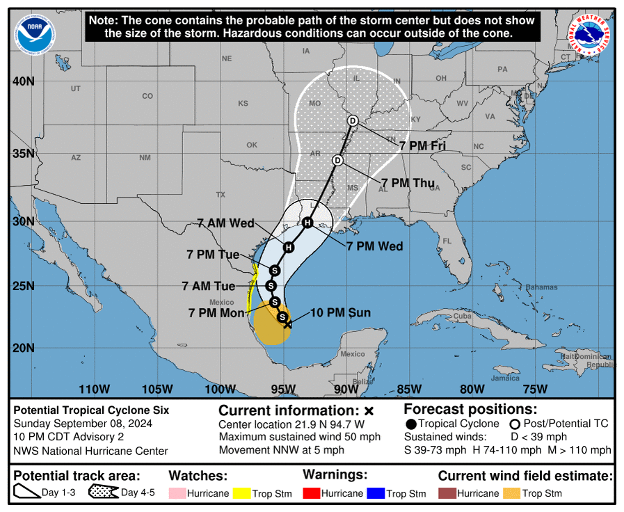
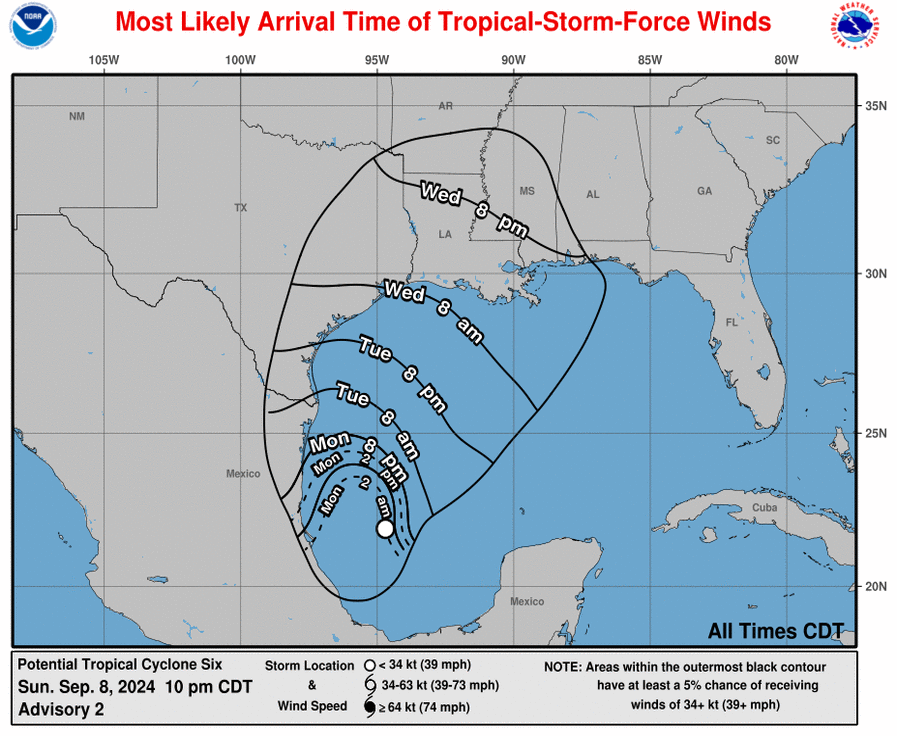
It has been nearly a month since the last named storm formed in the tropics, Ernesto, back on August 12. But soon, likely within the next day or so, we will have Tropical Storm Francine in the western Gulf of Mexico. Our confidence is high that a tropical depression or storm will begin lifting north on Monday, and move to within about 100 miles, give or take, of the mouth of the Rio Grande River on Tuesday afternoon or evening.
Not whole lot has changed in our thinking about the forecast today. It still appears most probable that the tropical system will turn north, and then northeastward, remaining off the Texas coast all the while. Yes, this is not a fully locked in forecast, and some uncertainty remains as indicated in the National Hurricane Center’s “cone of uncertainty.” Moreover, due to the storm’s angle of attack, even a subtle shift could bring the storm closer to the Texas coast, or possibly even inland.
However, at this time the most likely scenario is that the center of the system remains offshore and ultimately makes landfall somewhere in southwest or south central Louisiana on Wednesday or Wednesday night. A track toward Louisiana would mean that the system remains over water longer, and this among other factors favors additional intensification. It is possible that a Category 1 or even Category 2 hurricane ultimately makes landfall if the storm tracks toward Vermillion Bay and Lafayette, or further east.
For Houston, our potential impacts range from moderate to not at all impactful. This will depend on how close the center of the storm comes to Houston. Most likely, the majority of the Houston area will see only see modest rainfall totals, perhaps 1 to 3 inches, or even less. The coast could be more vulnerable to heavy rainfall, especially with a closer pass of the storm’s center. But I am not certain that even places such as Galveston Island will see heavy rains from the system. This forecast should be clearer tomorrow.
As for local winds and seas these are highly dependent on the track of this system/Francine. We should have more actionable information here by tomorrow morning. The high end for Galveston Island is probably tropical storm force winds, but I want to see more data overnight and on Monday morning.
Note: We’ll have a comprehensive update on the tropics, as well as a general forecast for Houston next week, first thing in the morning.

Thanks for working late for the update.
Yep! Thank you for keeping us updated.
You’re welcome!
Lovely….just what I wanted to deal with this week.
It’s not exclusive to just you, though. No one wants to deal with this LOL. Having said this, I’m very grateful for the Space City Weather team for updating us!
Never a good sign when SCW is putting out multiple posts on a weekend, but it’s reassuring at the same time. It gives us a good grasp on knowing what to expect or anticipate. We appreciate all that you guys do in keeping us informed.
Agree. Thanks for keeping us informed.
Appreciate the late Sunday night update. Ironic that I just checked NHC, then came here, and we have a current synopsis from Mr. Berger !
And yes, this morning’s walk was great and the evening walk the same – [doubled our walking distance because of the weather. Tomorrow morning should be a carbon copy, so anticipating another nice comfortable walk … too bad it won’t continue.
For us up here in Magnolia, we are not too concerned about a possibility of T.C.6 favoring the Houston area. We obviously will keep a watch.
Thank you sir! Really appreciate you sharing your knowledge!
Thanks Eric for the late Sunday update!
Thank you for the continuous weekend updates!
Thank you for your continuous weekend updates!
Hoping the storm stays away from the Houston and Galveston areas
Thank you. You guys remind me I am not alone. After many years in Hawai’i, I find Houston’s weather chaotic, like a mini-version of the future dystopia, weather-wise, at least. But I read your posts and am comforted. Yeah, it’s almost religious, definitely psychological. Thanks for being there, doing this for the rest of us.
Take the comfort with a grain of salt. They were 100% wrong about Beryl.
Really? 100% wrong?
If you’re going to criticize, perhaps you should be a little less hyperbolic.
“Hyperbole is often used for emphasis or effect. In casual speech, it functions as an intensifier: saying “the bag weighed a ton” simply means that the bag was extremely heavy. The rhetorical device may be used for serious or ironic or comic effects.”
Thanks as always for ad hoc update here! Know it’s baked into your answer, but isn’t a lot of this forecast premature as we wait for the two systems to merge and a true center forms? And if said center were to surprise and be more west than expected, might that change the cone and anticipated track here? Anxious to hear your answer here!