In brief: We’re keeping a close eye on the Gulf of Mexico, but all of our best data continues to suggest that a tropical storm forming there will remain off the Texas coast. At this time impacts in Houston look to range from modest to minimal, with rain chances dependent on how far the system remains offshore. After Wednesday, we’re likely returning to sunny skies and highs of around 90 degrees to end the week.
Potential Tropical Cyclone Six
We expect the tropical system developing in the southern Gulf of Mexico to drop the “potential” label and become Tropical Storm Francine within the next day or so.
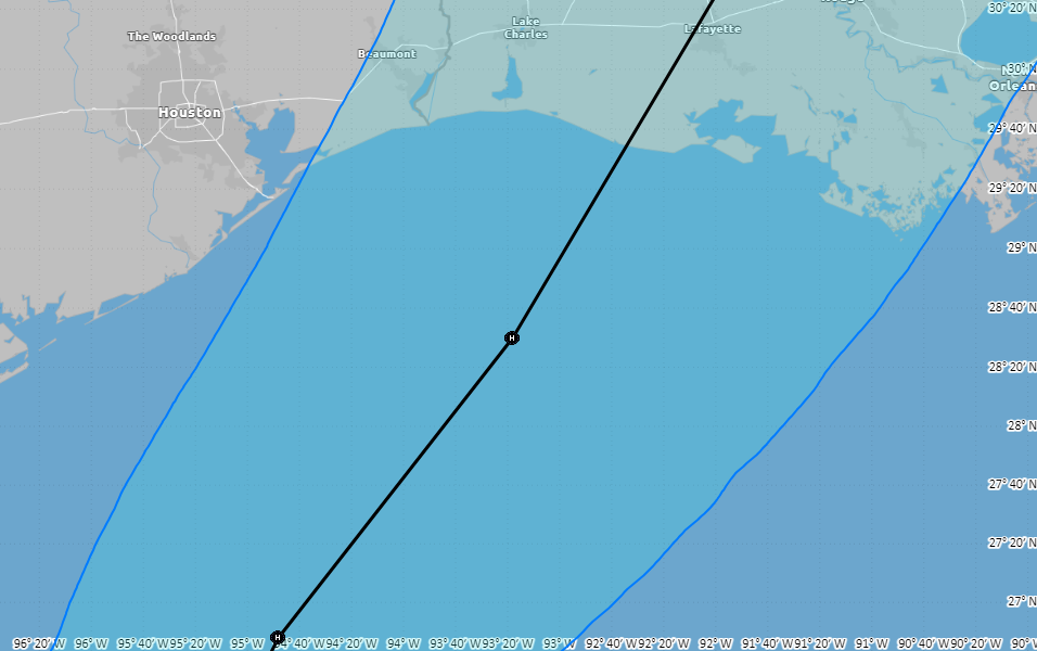
We have been saying for a couple of days that this system will move near the South Texas coast by Tuesday, but then is likely to remain off the coast as it turns northeast. Almost all of the computer modeling that matters continues to point toward this scenario, which would keep impacts in Houston at a modest level. The forecast could still change, but time is running out for this to happen.
So what will this mean for the greater Houston area? Our region is likely to see elevated rain chances on Tuesday afternoon, night, and Wednesday, especially for locations south of Interstate 10. In terms of accumulations, we still need to watch the development of the system, but at this time I don’t anticipate the potential for much, if any flooding, with the possible exception of areas immediately along the coast. As for areas inland of Interstate 10, the rain potential is significantly less.
In terms of seas, we’re likely to see tides elevated 1 or 3 feet above normal levels as the storm passes on Tuesday night and Wednesday. Winds will also be elevated during this time period, especially on Wednesday morning. Galveston Island could briefly see tropical-storm force winds, but I wouldn’t bet on that. These winds will fall off quickly for inland areas. The upper limit for winds in Houston, away from the coast, is probably sustained 15 or 20 mph, with gusts up to 30 mph or so. This should not cause significant issues with electricity distribution.
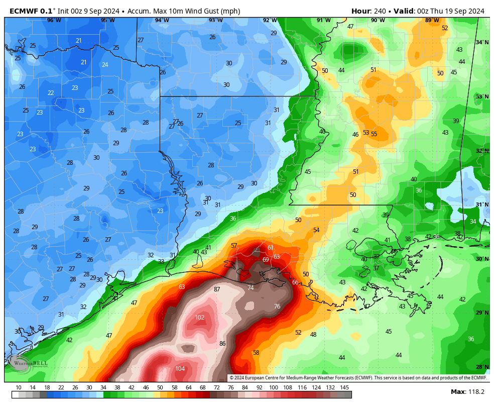
For impacts in Louisiana, which could be serious should Francine continue to develop into a Category 1 or Category 2 hurricane, please see our ongoing coverage at The Eyewall.
Monday
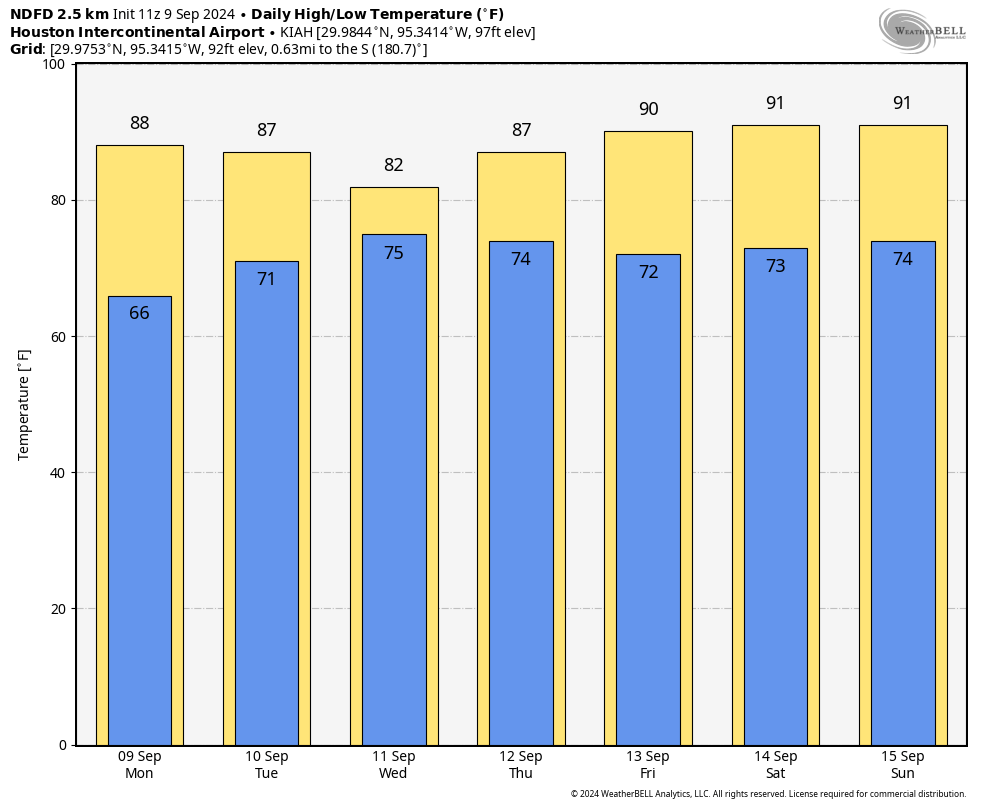
It’s a lovely morning in Houston, with temperatures generally in the mid- to upper-60s, and dewpoints in the lower 50s. This first taste of fall over the weekend has been wonderful, but it will soon be gone. High temperatures today will push into the upper-80s under mostly sunny skies, and humidity levels will follow (but it won’t feel Houston humid until Tuesday, as some modestly drier air lingers). Lows tonight will drop into the lower 70s for most of the city. Winds will be from the northeast at about 10 mph, with higher gusts.
Tuesday
Clouds return on Tuesday, and this will help to limit high temperatures to the mid-80s for most locations. We may start to see some rain from Francine by Tuesday afternoon, but this will depend on how well the system organizes, and how far its center remains offshore. These rain chances will persist overnight, with winds increasing in intensity overnight. Lows will drop into the mid-70s.
Wednesday
As described above, this is when the most serious impacts will occur from Francine, to the extent that they occur in Houston at all. Expect cloudy skies and high temperatures in the lower-80s. Rain chances will be high for coastal areas, and healthy for areas south of Interstate 10. I expect the rain to start moving away from our area by Wednesday afternoon or evening. We’ll see. Lows Wednesday night drop into the lower 70s.
Thursday and Friday
These will be a pair of mostly sunny days with high temperatures in the upper 80s to about 90 degrees as Houston lies on the backside of Francine.
Saturday and Sunday
The weekend should see more sunshine, but perhaps a few clouds mixed in as well. We are talking highs of around 90 degrees, with plenty of humidity, and nights with temperatures in the mid- to upper-70s. I can’t entirely rule out some rain, but chances are probably in the vicinity of 20 percent.
Next week
I think we’ll remain in a fairly warm, late summer pattern for much of next week with highs in the vicinity of 90 degrees, or low 90s. We’ll see some additional rain chances from time to time, but nothing that looks too extreme. I don’t see much evidence for a cold front within at least the next 10 days.
Note
We will publish an additional update on the tropical system by 4 pm CT this afternoon.

Great news for us in Houston. Not so great for our neighbors in Louisiana.
Grass could use a little more tropical weather. But I’m good to pass this buck to our neighbors
Katy, TX Born and Braised here! We gonna go ahead and evac just to be safe.
When you do leave, please take all the concrete north, west and south of you with you. Development has become ridiculous. I miss the rice fields and the geese that used to drop in for a feed. Heaven knows where the wild life has gone. The vastness of the greater Houston megalopolis is appalling. Very soon we’ll all need to take a plane ride just to get to the edge of it all.
Development has been expanding for decades Ken. its not gonna stop for the geese or any other creatures. Talk to your local officials, state or federal if you want changes, doubt they will do anything but at least try
That wouldn’t work; all elected and other officials ever talk about is “Growth, Growth, Growth”. Maybe they get paid to talk it up.
Of course they do. Money is the only green you’ll be seeing here.
Core-rupt.
As a goose, I hope your land becomes ours someday. Houston? More like gooseton.
Fellow Goosetonian, I can only share your hopes. We, and our fowl brothers and sisters, await the day of the return of our land: “The Goosening.”
Yeah, every place but yours needs to go; the development which resulted in your home was fine.
First experience duck hunting in 1958 as a 7 year old on the rice levee Katy Prairie . Wooden pickle barrels were sunk in the levee as a blind. Plenty of dewberries to pick. My uncle worked & lived at the Humble Oil & Refining Gas Plant & Camp.
Those were egrets, Ken J
It was a really nice morning. To bad this will probably be the last cool morning until early October.
Another nice cool morning up here in Magnolia. Went off for an extra long walk – we actually put in our full daily step count all this morning! Plus I just finished mowing a couple acres and it’s only at 71 degrees! Will mow the rest later.
Much more relaxed with all the recent reports on “6”s predicted path -not- to the Houston area. Throughout the day, we hover on SCW, Fox 24 Hour Weather channel, CW39, NHC, and Ventusky, plus 1 or 2 orhers. All are in agreement as to the potential path.
Funny side-note – Mike (meteorologist) at Fox26Houston wasn’t convinced at the naming of 6, because the other Atlantic disturbance could potentially win the name Francine and 6 would get Gordon 👍
Whoa whoa whoa, what’s this about another hot and humid weekend? This crap is over, I thought.
Are you new here? lol
Someone doesn’t know about fake fall, lol
Will the wind wrapping around the storm give us a north breeze that might still feel relatively nice? As long as the storm stays far enough away
I’ve had northeast winds at 20-25 the last five days!
Unfortunately, the temperature has not dropped below 66, so fall day is still better later than never!
Just checked NHC website … we NOW have Francine in the Gulf !? 👍
The forecast cone for Beryl two days prior to landfall had the hurricane missing Houston metro…
If this was perfect science, we would not be at this site trying to get “the latest”. Eric is awesome keeping us up-to-date without the hysteria of nearly all other sites.
Well, we were inside the cone of uncertainty for Beryl two days out if I remember right, on the extreme eastern side. For Francine, we are outside the cone; the western edge of the cone basically goes over Port Arthur. If the National Weather Service blows this one they will have some explaining to do.
I was curious so went and looked at the history and Houston was in the cone of uncertainty for 4 days prior to landfall. Basically since before it hit Cancun. That’s about the best you can hope for over half a week out.
Earlier development means the tracks now (10:30AM) have shifted more EAST. Literally dodged a bullet.
Looks like we will be on the dry westside of the storm. This means that dry continental air will wrap around the west side and choke out any significant rain from being able to develop. I wouldn’t expect anything more than some light off and on showers with some gusty winds here and there. I’m guessing that inland areas of Matagorda and Brazoria County will probably see lest than half an inch of rain.
That’s good 😀
“Houston Humid” needs to be on a t-shirt.
It’s on all of mine as soon as I step out the door.
If you live in LA you are not thinking to “take one for the team” right now
Just like we wouldn’t if it was hitting us. We all take a hit on the gulf coast. Better to just hope it fizzles out than to hope it hits our neighbors though or somehow skip us gulf coast states and hit the midwest 😂.
Louisiana has taken about a half dozen for the team recently. They gotta be tired of being such a good teammate lol
Thank you for the updates! Hopefully the storm isn’t too bad for Louisiana!!