In brief: Tropical Storm Milton formed in the Gulf of Mexico this afternoon. Normally, a tropical system in this part of the Gulf would be of serious concern to Texas, but since we’re now in October, the overall steering pattern generally pushes tropical systems away from our state. We’re sharing this post from The Eyewall because we’ve had several questions about Milton, and know many readers have family and friends in Florida.
At 5 pm ET on Saturday, the National Hurricane Center upgraded a tropical depression in the extreme southwestern Gulf of Mexico into Tropical Storm Milton. The center of the storm is nearly stationary this evening, but it should start to move slowly to the east over the next day or so before accelerating. Although it is unusual for a tropical system this far west in the Gulf of Mexico to move toward Florida, that’s exactly what we expect to happen over the next four days in response to blocking in the mid- and upper-levels of the atmosphere.
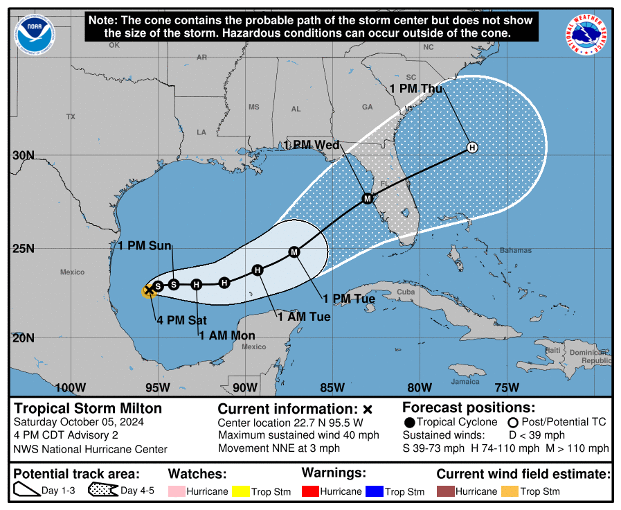
Although we remain about four days—give or take—from a landfall along the west coast of Florida, it is important for residents of the state to take Milton very seriously. We realize that some areas of the state remain dazed by Hurricane Helene, but this is a similarly threatening storm. Although we don’t have full confidence in precisely where the storm will track, it does seem very possible that it will directly impact the greater Tampa-St. Petersburg-Clearwater metro area, which has a population in excess of 3 million people.
Please remember that the forecast can and will change in the coming days. However, we have seen a fair amount of tightening in the model solutions over the last 24 hours, and increasingly they are pointing to a powerful hurricane approaching the western Florida coast, possibly near or north of Tampa Bay, by around Wednesday of next week. This post will discuss our preliminary assessment of some of the impacts from this storm.
Track and intensity
There remains a broad cone of uncertainty in regard to where Milton will go, but we can expect this to narrow somewhat during the next day or so. After Milton wobbles around the southwestern Gulf of Mexico for the next day or so, it will get picked up by a front moving down into the northern Gulf of Mexico. This will help steer the storm the east, and then the northeast over the next few days.
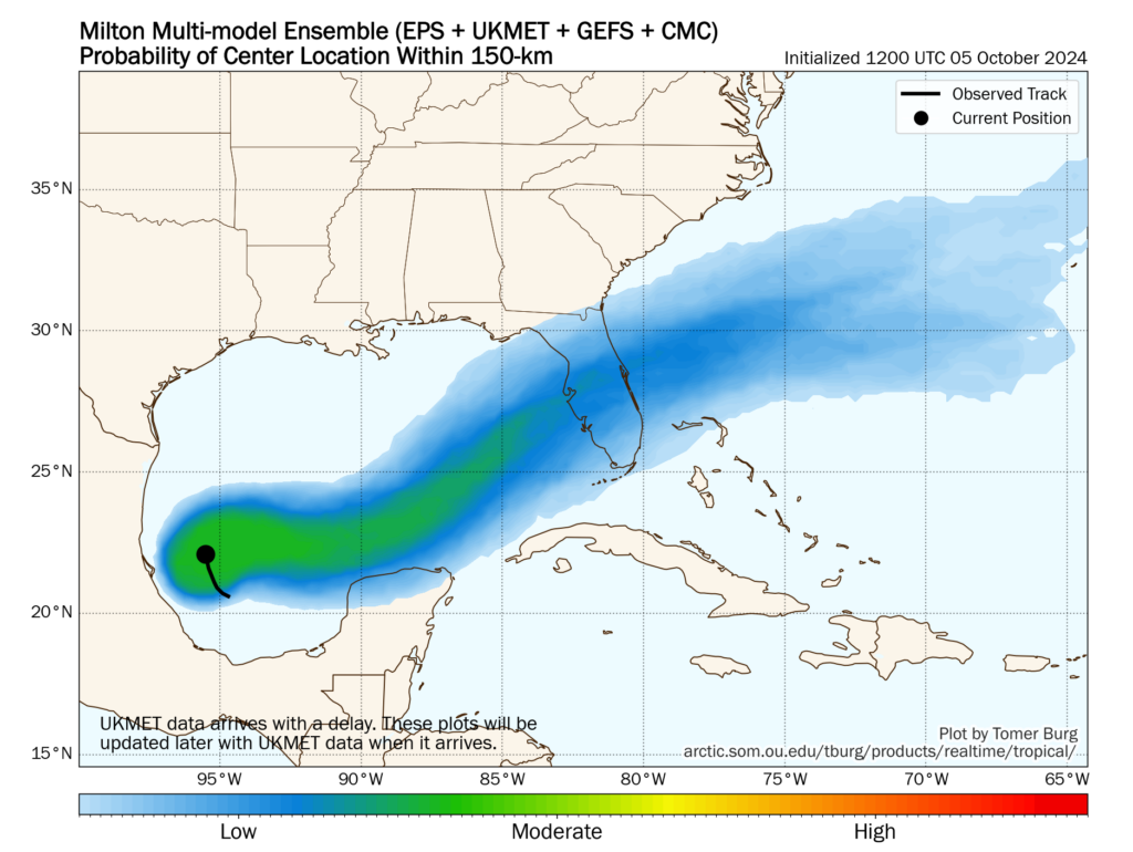
Most of our best modeling guidance, including hurricane specific models such as the HWRF and HAFS, brings the storm to the western coast of Florida, near the Tampa Bay region, very late on Tuesday night or Wednesday. Now that a fairly well defined center of circulation has formed, I expect modeling agreement to increase over the next day or so.
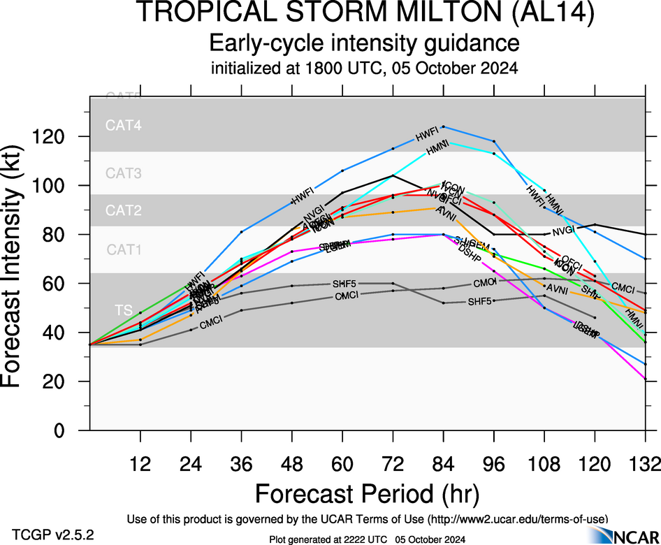
In terms of intensity, there is a broad range of outcomes. The National Hurricane Center predicts a major, Category 3 hurricane at landfall on Wednesday. However, an even more powerful storm is possible given that the Gulf of Mexico is very warm, with deep oceanic heat content, and wind shear levels unlikely to disrupt Milton’s organization. Unfortunately, this is a setup for the development of a large and powerful hurricane.
Winds
Milton’s track will determine where the storms strongest winds occur; they will be along the path of the center and generally just to its right. The majority of our guidance continues to point to a hurricane somewhere between Category 2 and Category 4 intensity, which means that there is the potential for a large stretch of the Florida peninsula to experience hurricane-force winds. This level of winds will cause significant damage and likely lead to power outages.
Storm surge
With four days to develop, Milton is ultimately going to push a large and powerful storm surge toward Florida. This storm will almost certainly impact areas south of where Hurricane Helene struck in September, but at this point anywhere from the coastal bend of Florida, south to the Tampa Bay area, and further south to Fort Myers, is at risk. It is too early to talk about absolute risks, but for wherever Milton makes landfall, the storm is likely to bring a historically damaging storm surge. These impacts will be most pronounced just to the right of where the hurricane makes landfall—which again, is a location that we cannot say with any certainty yet.
Inland rainfall
Heavy rainfall is another threat from Milton. Although the storm should be moving at a fairly good clip once it reaches Florida by the middle of this week, Milton could nonetheless drench a swath of the state, from west to east as it crosses the state. Whether this occurs in the central part of the state, such as the vicinity of Orlando and the Space Coast, or further north in the coastal bend and Jacksonville, is just not clear yet. However, the risk is there for 10 or more inches of rainfall in a short period of time, which will lead to flash flooding.
Conclusions
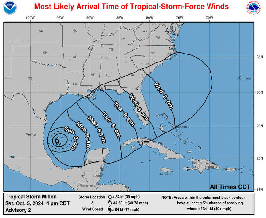
If you’ve read this post up until now, you’ll realize that we cannot say much more at this time beyond stating that a serious hurricane threat is coming to the state of Florida this week. Sunday and Monday will be a time for preparations, as impacts such as wind and heavy rain are likely to reach the state as early as Tuesday evening.
We will have continuing coverage on The Eyewall as this very serious threat develops.

And FEMA is out of money! 🙏🙏🙏 for Florida!
I pray hard for Florida…
I’m not so sure that FEMA is out of money..I hear and read something different every day..
For preparation I would look to be on my own for 7 days at least, possibly without ANY help, if I plan to camp in my home..
It takes TIME for help to infiltrate an area…And it’s only going to be basic help, like food(MREs), and water, from my experience..
9 times out of 10, I’m going to need to go to where the food is at..Convention centers and other locations throughout my city..
I personally don’t expect the government to be able to hone in on where I’m stranded, and be able to drop hot meals or groceries in my lap, the minute a hurricane clears my area..I don’t expect the govt to be able to whisk me away to a 4 star hotel..The kind of emergency help I would probably need, would have to come from private citizens or first responders in my city, initially, because they have more immediate knowledge of the impacts and damage in my neighborhood ..
Our governors and mayors have to go through the motions to get us help from the feds..
I think we have to document or show how uninhabitable our homes are, in order to get vouchers for temporary housing..Vouchers to replace lost food are quicker to receive, but still take weeks..
The federal and local governments have to help feed and hydrate several million people in the aftermath of a devastating storm/disaster, along with sending supplemental medical help to the devastated area..
I don’t expect the federal or even the local government to have the capability or the know how to rebuild my whole life for me…
If I were you, I think I’d get the heck out of there. There’s no sense in risking your life by staying at home.
This is why I don’t live in Florida. Darn storm is going to blow right through the state and come out the other side. Last model run I saw had it as nearly a Cat 4 going in and a Cat2 over Orlando.
At this pace, the only residents in Fla will be those that can afford to pay a 100+K deductible. And are mobile. Nothing but high end stores, everything else delivered. More land available. High taxes. Some kind of housing arrangement for services. Will be interesting to observe the realignment with high frequency storms as it’s still a desirable location (98% of the time).
Those are people in FL facing another nightmare, not a interesting social experiment to observe.
Wow.
Praying for Florida..I’ve never visited, but I’m a beach person and feel for the people who live there..The damage to lives, ecosystems and property is horrendous..
I really really wish we as a society had the technology and gumption to let the average homeowner have the financal ability and knowledge to pick materials and design plans to build a home to withstand powerful hurricanes, with materials that only need a good hosing down after being flooded…
I wouldn’t say zero impacts, I’m sure the upper Texas coast will have some long period large swells.
You know more than the professional meteorologists?
There will be swells. The Texas Gulf Coast isn’t magically separated from the rest of the Gulf.
Nothing happens in isolation.
Any idea what the water and beach will be like in Cancun from Thursday on? I hate to think we’re going to see all the pretty water and beach and just have it be churned up.
That CAG is a nightmare. I wonder how long it’s going to be parked down there.
Storms named “Milton” and “Berle” in the same year?
What’s up next year, storms “Jackie” and “Gleason”?
This isn’t funny.
Correction: Beryl … might have gotten a snicker if there was a “Berle” 🙂