In brief: This tropical update has been cross-posted from our companion site The Eyewall. Although we do not yet have major concerns about direct impacts to Texas from Beryl, it is not out of the question that the storm could get into the Gulf of Mexico this coming weekend. Since we have been receiving a lot of questions about Beryl, here’s what we know right now.
Overview
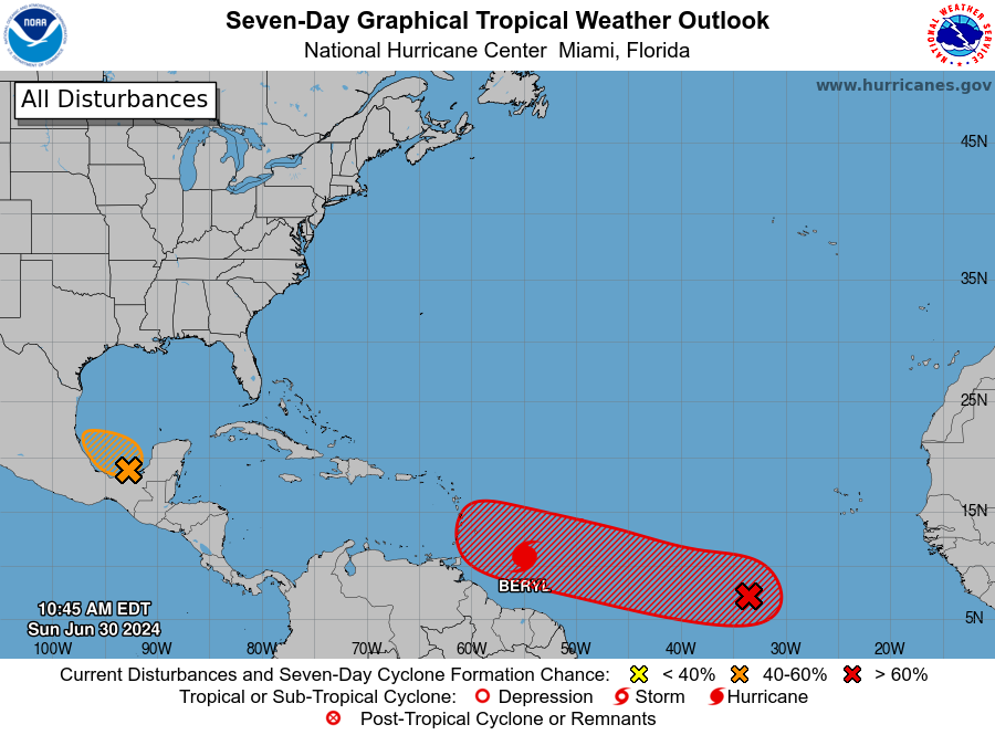
As of late morning on Sunday, the tropical Atlantic remains very active for the end of June. In addition to Beryl, there are a couple of systems the National Hurricane Center is monitoring for potential development. We’ll comment on those at the end of this post, but our primary focus today is the rapidly developing Beryl, which as of 10:35 am CT is a dangerous Category 4 hurricane.
Hurricane Beryl this week
Thanks to warm seas, the system has intensified during the last 24 hours from a 50-mph tropical storm into a powerful 130-mph hurricane as it nears the Windward Islands. It should then cross these islands on Monday and move into the Caribbean Sea. The storm will likely remain sufficiently south of Puerto Rico and Hispaniola to preclude serious damage there, but it could threaten Jamaica on Wednesday and Central America and the Yucatan Peninsula toward the end of the week. After that? Movement into the Gulf of Mexico is possible, but after this point our confidence starts to decrease.
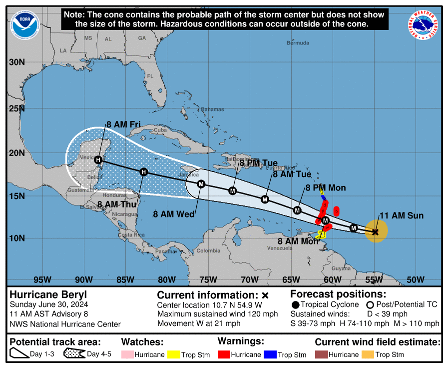
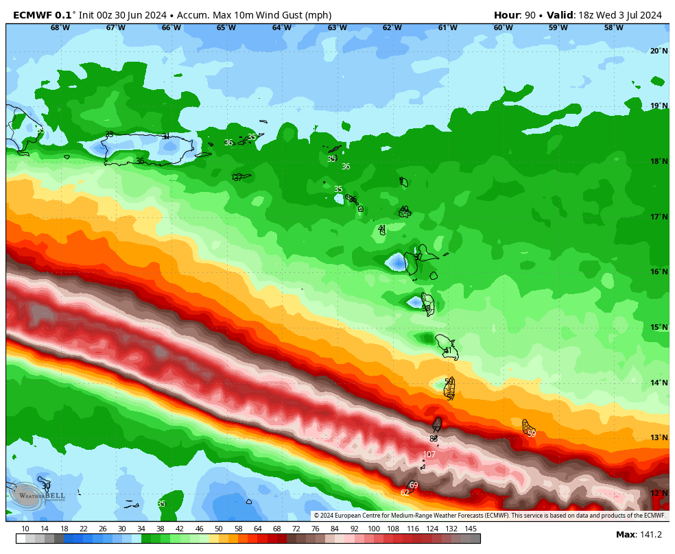
In terms of intensity, additional strengthening of Beryl is likely over the next 24 hours or so as Beryl traverses very warm seas and is encountering relatively little wind shear. The National Hurricane Center forecasts a peak strength of 140 mph sustained winds by Monday morning, when the storm passes near islands including Grenada, Barbados, St. Lucia, and Martinique. These locations should prepare for the most intense wind and surge impacts beginning after midnight tonight, and lasting through at least Monday morning. Localized rain totals of 6 to 12 inches are possible. This is a very serious situation, and residents should prepare accordingly.
As it moves into the Caribbean Sea on Monday and Tuesday, Beryl should encounter moderately stronger wind shear, and this probably will cause some weakening. But the jury is very much out on how much weakening will occur before Beryl approaches Jamaica on Wednesday. The National Hurricane Center forecasts the system having sustained winds of 120 mph at that time, but this is just a reasonable guess. By Thursday night or Friday, as the center approaches Belize and the Yucatan Peninsula of Mexico, it’s likely that Beryl will weaken a little bit further. It will still likely bring hurricane-force winds to these locations sometime between late Thursday night and Friday night, in addition to heavy rainfall.
Hurricane Beryl this weekend
Our certainty about Beryl’s track begins to fade by the weekend. From now through Friday, a fairly strong high pressure system should continue to push the storm westward. Over the weekend and into early next week, it is possible this ridge continues to steer Beryl westward into the Bay of Campeche. (It is not clear how much interaction with the Yucatan would disrupt Beryl’s circulation, but some weakening is virtually certain). In this scenario, Beryl is likely to move across the southern Gulf of Mexico and plow into the east coast of the Mexican mainland, similar to Tropical Storm Alberto about 10 days ago.
However, there is also the possibility that this ridge weakens, somewhat. At this point, this remains a lesser likelihood when we look at the global models. Still, there is a non-zero chance that Beryl turns northwestward after encountering the Yucatan Peninsula. In such a scenario a tropical system—be it a tropical storm or hurricane—could come to the Texas or even Louisiana coast late next weekend. I understand that everyone would like to have absolute answers about whether this will happen, but we just don’t have that kind of certainty right now.
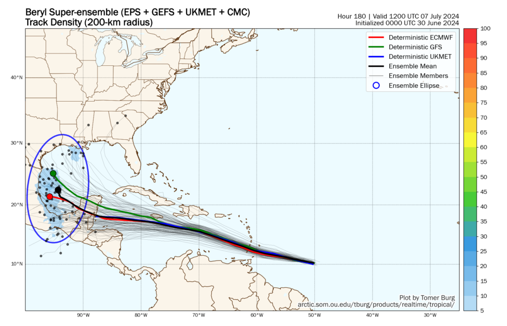
Bottom line: Direct Texas impacts are within the realm of probability from Beryl, but the odds remain fairly low. We can see this distribution of possibilities when we look at the “super ensemble” track of forecasts for Beryl, which favors the ridge holding strong. We should know more about this part of Beryl’s forecast by Monday or Tuesday, and of course we’ll remain on top of that.
Invest 94L
There is still a short window for this tropical disturbance over the southern Gulf of Mexico to develop on Sunday before it likely moves inland into Mexico on Monday. The primary threat from Invest 94L is heavy rains in southern Mexico and Central America, which saw similar impacts from Alberto just 10 days ago. Regardless of whether this system develops further or not, the effects will be the same. There will be no impacts for Texas.

Invest 96L
The third area of tropical interest is trailing Hurricane Beryl by a few days as it traverses the open Atlantic Ocean. The National Hurricane Center gives this system a 70 percent chance of becoming a tropical depression or storm during the next week, and at this point it seems likely to impact the Windwards Islands in a similar location. This could happen as soon as Wednesday, and could deliver an awful second whammy.
However, I have some questions about how much Beryl will perturb the ocean and atmosphere, and this could help to mitigate the strengthening of this tropical disturbance as it nears the Caribbean Sea in a couple of days. We will be keeping a close eye on the system, in any case.

Thank you for keeping us informed!
Thank you for sending an update out over the weekend!
Would be nice to possibly highlight the perimeter of states in your radar pictures and also add the high & low pressure systems in place while reporting. Thanks!
We are suppose to fly out on Tuesday (7/2) for a wedding in Jamaica on (7/3). So far, there are no cancellations from the airlines. Should we try to cancel our trip now?
Totally honestly, I would. It’s not going to be a good time out there.
Supposed to be in Belize tomorrow through Sunday – any thoughts beyond continue with the trip for now but monitor the storm?
You might want to look into coming back Wednesday
We have a beach day planned in Galveston in Friday while Beryl is passing over the Yucatán. Do we have any idea about rip currents affecting that far north?
Could Invest 94L impact the trajectory of Beryl if it’s still active once Beryl enters the Gulf?
We are suppose to be in Cancun from July 4-9. Should we cancel now or wait a few more days to get updated information?