In brief: We are sharing a post we just published on our tropical companion site The Eyewall that talks about the next system expected in the Gulf this coming week. At present, we think it will likely stay east of Texas and is more a concern east of New Orleans to Florida. Still, we’ll watch it to be sure. We also have some links for folks that may want to help our neighbors in Appalachia that are dealing with an absolute catastrophe due to Helene.
Our thoughts are with folks impacted by Hurricane Helene. From what I have read and seen and heard about some parts of western North Carolina and Tennessee, it’s really, really bad. Worse than might be known at this point. Speaking as someone from Houston, which was has dealt with floods and then been flooded with resources after storms, these more rural communities are likely to be dealing with this for a long time and will need a *lot* of help in the weeks and months ahead, as the resources and media attention don’t always focus on places like that.
Keep in mind that after catastrophes like this, “stuff” is nice to donate but what is really needed is money. So consider that if you’re looking for ways to help. The United Way of North Carolina has a fund setup specific for Helene. Blue Ridge NPR has a nice list of organizations you can donate to as well. There is also the East Tennessee Foundation for folks there. Please post any other organizations in these areas in the comments.
As of late Sunday morning, there are still about 2.5 million customers without power from Florida to Ohio. This is down from a peak of around 4.5 million. It will take a long time to get to some areas in mountainous and rural western North Carolina and eastern Tennessee though, and some of these locations could be without power for weeks; the damage is just that complete in these areas.
Storm surge is the deadliest aspect of a landfalling hurricane, but inland flooding can dwarf that sometimes. We’ve seen it time and again in the last several years. If you live inland in the Southeast, Mid-Atlantic, or Northeast, you need to be prepared for hurricanes too.
There will be a lot more to discuss with Helene which we’ll save for another day. But suffice to say we have seen the worst-case scenario play out a lot more often in recent years. And this is going to be a big discussion point going forward both in how forecasts are communicated and how communities prepare for storms. You can’t rely just on the known lessons from past disasters anymore.
Forecast this week
The upper low and remnants of Helene will continue to produce generally light showers across the Midwest and East the next couple days before finally being ushered off to the east later this week. There will be pockets of steadier rain though, particularly in Virginia and West Virginia. Total rainfall over the next 5 days could add up to a couple inches there.

Localized flash flooding is possible today and tomorrow in the mountains there or Shenandoah Valley. These areas were not as severely impacts as areas to the south, but they remain vulnerable to localized flash flooding impacts.
Gulf & Caribbean: Something to watch
So what comes next? Unfortunately, the NHC now has a 50 percent chance of development somewhere between the Gulf and northwest Caribbean over the next 7 days.
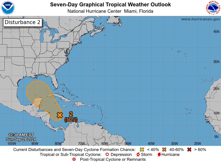
For our many readers in Texas, at this point, I would not expect this disturbance to come this far north and west. It will take at least the next 3 to 4 days to develop, and by the time it matures enough, it appears a cold front is headed toward the Gulf that will likely carry this back to the north and east. What this means for places from New Orleans through Florida is still a bit unclear. Modeling is sort of all over the place. At this point with Helene, we had basically two very distinct camps, one that buried the storm near the Yucatan and another (that got it right) carrying it north and northeast as a stronger storm. For this system, we have a similar sort of mixing of outcomes but there’s not exactly a distinct grouping of camps. In other words, there’s a good deal of uncertainty. The GFS ensembles are mixed, with some favoring a stronger storm headed back toward Florida and another group that ends up weaker. Some modeling doesn’t develop this at all. The ICON and European AI models generally show slower development and slow movement.
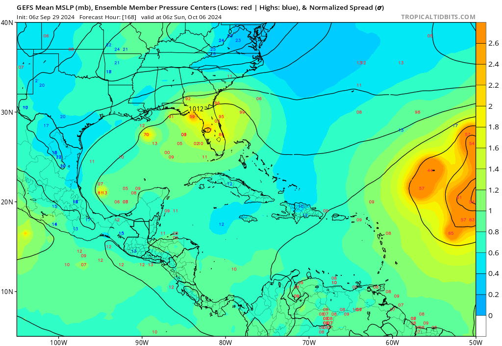
Given the uncertainty here, it’s important to continue to monitor this over the next couple days, especially in the eastern Gulf. But I will say that the more mixed nature of things in modeling makes me feel that a Helene redux is unlikely in this scenario. That said, keep watching. Impacts, assuming the system develops would likely occur next weekend.
Elsewhere in the Atlantic: Kirk to come
We currently have two active systems, Hurricane Isaac and Tropical Storm Joyce. Neither are direct threats to land.
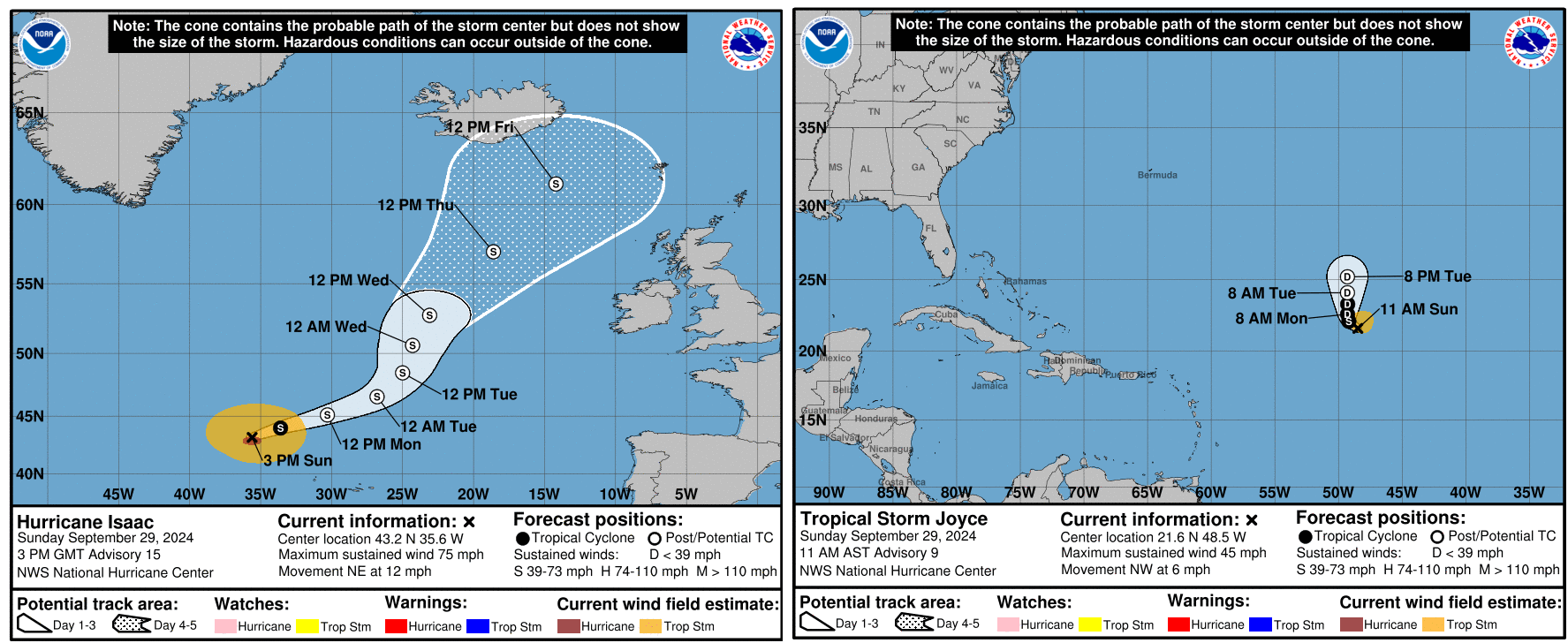
Both storms should lose tropical characteristics over the next 3 to 4 days and dissipate. Isaac will become part of a larger storm just north of the British Isles, as is periodically the case with North Atlantic storms.
Meanwhile, there are two additional areas to watch in the eastern Atlantic. First, there is Invest 90L, which looks like it’s ready to go off to the races. This one should turn northwest and north, generally following Joyce.
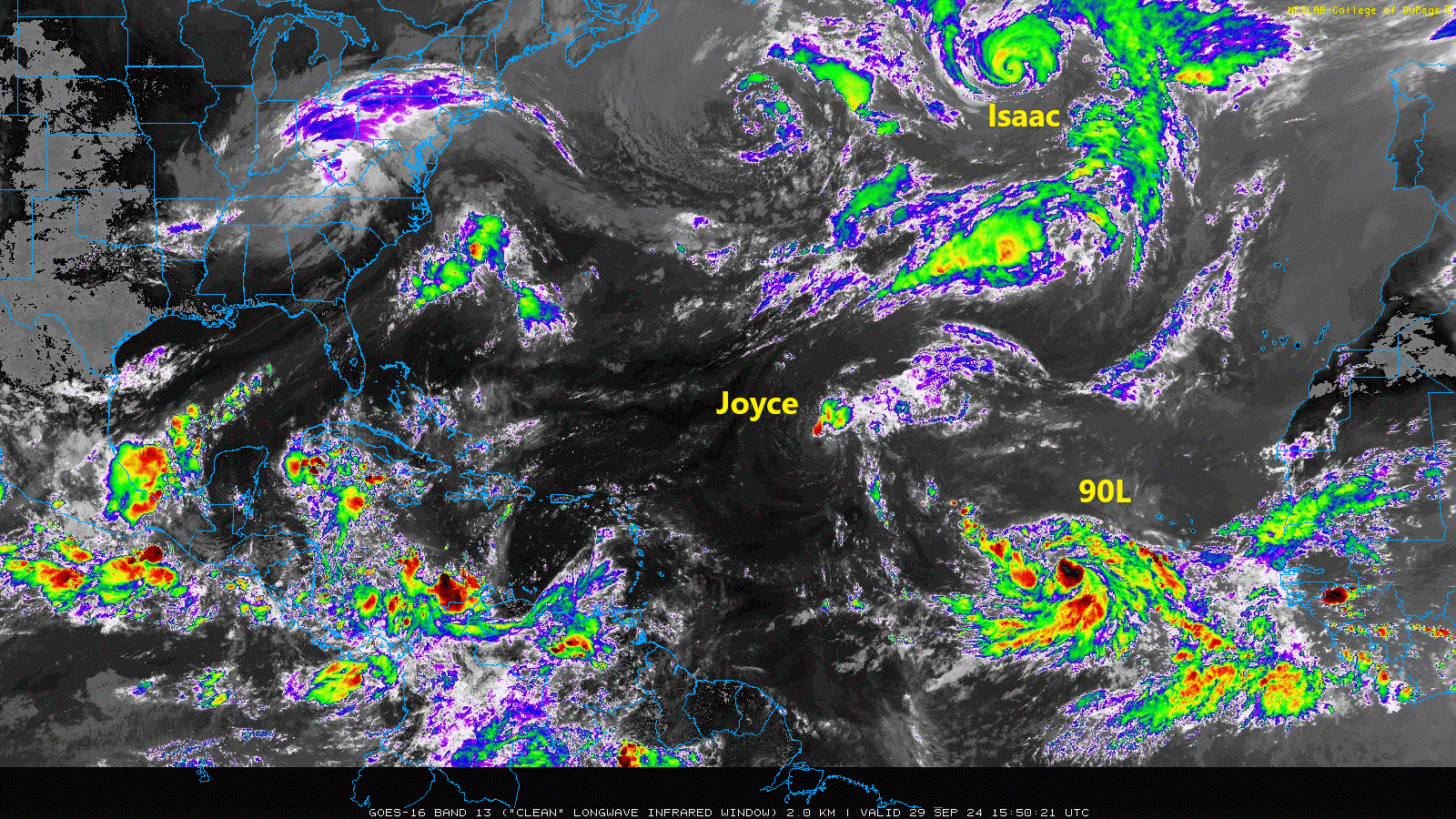
The next name up is Kirk. Although this one is expected to go out to sea it’s worth keeping a side eye on for the Caribbean and Bermuda at least.
Behind 90L we look to have another disturbance in that cloud cover back off Africa. This is not expected to develop quickly meaning that it could come a bit farther west across the Atlantic. I might say that this one is more concerning in some aspects that what should become Kirk. If this can sneak west enough, it may find its own little environment to get going in. There’s not a ton of model support for this one either way, but interests in the Caribbean should at least keep an eye on it over the next 5 to 7 days as it comes west.
So over the next 7 to 10 days we likely have at least one more Atlantic storm and one more Caribbean or Gulf system. We may get a third storm in the Atlantic toward the end of that time horizon. Getting to (L)eslie or (M)ilton would put us at 12 or 13 storms for the season with a good 3 to 4 weeks of potential to go. Still far short of preseason expectations but somewhat less of an error. We’ll watch everything over the next couple weeks and keep you posted.

🍂🍂 🎃 cold front! 🎃 🍂🍂
That would be nice, but the next one will probably still be similar to the previous two, drier air with a northerly breeze, overnight temps in the mid to low 60s (depending on location) and daytime highs in the upper 80s to low 90s.
With 10 inches of rain we have flooding in flat Houston but in those mountains, add in the velocity this water gains due to the elevation changes and channeling through these canyons, incredible.
Thank you so much for drawing attention to the catastrophic conditions in East Tennessee and western North Carolina. Communities and towns were literally washed away. Having moved here from Houston, I am familiar with hurricanes and the damage associated with them, but I have never seen such destruction.
Everybody I know, including myself thinks that hurricanes have gotten larger and meaner, and more of them over the years..I agree with you, there has to be a discussion about forecasting and preparedness in the years going forward..
Maybe think outside the box for life on the coast in buildings that are hurricane resistant, flood resistant…It’s either that or not build, rebuild, live on, or near the coast..As for the inland catastrophic damages across a large part of the country, I am praying this is a strange occurrence that will not become more commonplace as hurricanes move inland..
Hurricanes that caused flooding in multiple states at a time have actually happened alot in the past but you will rarely ever hear about historical weather disasters. 3 good examples to look up are Hurricane Diane and Connie of 1955 and Hazel in 1954. Hurrican Hazel was a cat 4 that struck North Carolina in October mind you.
Thanks for sharing…I’ll look those up..
Hello, Matt and Eric and everyone on SCW! I survived Hurricane Maria (Category 4-5) in Puerto Rico in 2017 and the experience was absolutely traumatic. The devastation was so terribly overwhelming. My heart is aching for survivors of Helene, especially in rural areas. Children and the elderly will need a lot of support. Thanks for calling the attention to this and asking people to contact SERIOUS organizations and make monetary donations. So much stuff was donated to Puerto Rico that never got to us. Hospitals and nursing homes will be particularly vulnerable. Hot meals are going to be necessary, especially a few weeks from now, in places where power will be harder to reestablish. Making mental health services quickly available for these areas is also an absolute must. Money can be used in the weeks and months to come to assuage this situation much better than “stuff” can. Please, if possible, keep reminding people via your platforms every week, for a few weeks, about our neighbors affected by Helene. Reconstruction will be hard, but feeling cared for and supported along the way will help them keep going.
I agree, periodic reminders of places to donate will be good..I will add these to my calendar..
I appreciate the groups and organizations that comment here to give us info on how we can help..
When Beryl came through my neck of the woods, it was a couple of days before cooling centers could be established..Trying to find fuel, or a hot meal was like finding a needle in a haystack..Finally, MRE pickup was established in about a week post Beryl..
A lady in our neighborhood was a lifesaver … The minute our electricity was restored, she got busy and cooked hot food every day to feed people in our community..She cooked evening meals every day for about three weeks..We would donate food and money to her when possible ..She managed to spread the word about what she was doing, through social media..Helped a lot of families..
This sweet lady stated that things went so well from her standpoint, that she will cook for the community in the future when disasters hit our neck of the woods…Houstonians, you may have heard about her if you had a chance to watch KHOU news in the aftermath of Beryl..
Thank you for highlighting the differentiation in resources for urban storms vs. rural storms and sharing the resources. Rita was a case in point after it went right over the top of the Piney Woods with little to no media amplification. New Orleans was still reeling from Katrina, the evacuation debacle was the headline, and the densely populated woods made it difficult for media to capture aerial footage. Thankfully, there were angels in the mix, helping people get back on their feet. IDK if it was the Cajun Army or retired servicemen who came through and cleared 50 downed trees at a family property, but they did it in a couple of days. We bought as much water as we could fit into two SUVs and drove it up from Houston to fill troughs so the animals had water. No electricity meant the pumps weren’t working. Thankfully, the roads were passable. I hope the folks in NC who are impacted and isolated get the longterm help they’re going to need.
Samaritans Purse does great work to provide relief and support after catastrophic events. A worthy organization to donate to. They also invite volunteers to come on-site to help assist.
How many of the storms this year that stayed way out in the ocean would have even been recorded 20, 40, or 60 years ago? Does our technology now to see these add to the narrative of there being more storms than in the past?
Matt — thank you so much for providing links to donate to Helene relief. Appreciate all that you, Eric and the team do here!