In brief: Houston faces two days of record-setting heat before a nice front arrives on Tuesday night to usher drier and cooler air into the region for the rest of the week. Rain chances, unfortunately, continue to look fairly low. Also, if you have a clear view of the Western sky, we encourage you to look for a new comet near the horizon.
Houston likely to set record high
The region’s high temperature on Sunday was 94 degrees, which is one degree short of the city’s record high for October 13. Today we’re likely to be even a bit warmer, with highs in the mid- to upper-90s for much of the metro area. And the record high for today, set in 2015, is just 92 degrees. So we’re almost certain to set a record today. Tomorrow we are also likely to set a record, beating the mark of 92 degrees set in 2019. A cold front finally arrives on Tuesday night to bring us some much-needed relief.

Don’t miss a comet in the night sky
If you have a clear view of the western horizon, preferably with few lights (i.e. not looking directly toward downtown Houston), you should try and see a comet with an unwieldy name, C/2023 A3 Tsuchinshan-ATLAS, this week. To find it, look toward the western horizon within 45 minutes of sunset at twilight. A pair of binoculars should only enhance the view, so if you have some, bring them along. The comet will fade in the next two weeks, so right now is the best time to try and see it.
Monday and Tuesday
Heat continues for two more days. Both Monday and Tuesday will be sunny, with high temperatures in the mid- to upper-90s for most locations away from the coast. This is brutal, August-like heat that is very much not normal for October (hence the record-setting temperatures). At least the dewpoints will be a little lower, so it won’t be incredibly sultry heat. Winds will be light, from the north and northwest, at 5 to 10 mph. Monday night will be warm, with lows in the upper 60s.
Wednesday
Drier air starts to move into the area by around midnight, and dewpoints will fall into the upper 30s area wide by Wednesday morning. It will feel noticeably drier, and daytime temperatures on Wednesday may be only on the 70s. Winds will be from the northeast, gusting up to 20 mph. Skies will remain sunny, as this is a dry front. Lows on Wednesday night will drop into the 50s area-wide, except for the immediate coast.
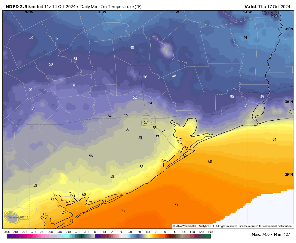
Thursday and Friday
These will be a pair of mostly sunny days, with high temperatures in the upper-70s to lower-80s, with nighttime temperatures in the upper-50s to lower 60s. So, pretty pleasant.
Saturday, Sunday, and beyond
We may start to see some clouds this weekend as a southerly flow returns. Whether that brings any meaningful rain chances is something we’ll have to wait and see, but overall the odds do not look great. Highs are likely to be in the mid-80s for much of the region, with lows in the 60s. There’s probably another front in the cards some time next week, but the details are hazy.

October has been a really pleasant summer, cool enough nights, not too hot or humid days, can every summer be like this?
Right lol. We pretty much have 3 seasons here in SE Texas, hot, hotter, and hottest.
This is what I like to call Augtober.
Absolutely disgusting. God I hate this city.
How many more days until the move?
Two months. 😀
18-24 months for me…..assuming they actually let me retire….I’m encountering some resistance that plan.
Can’t you move sooner?
The feeling is mutual.
Ahh October, when God finally decides to pay the Texas A/C bill.
Then, because it hasn’t run in 8 months, the stupid thing breaks down immediately and he decides we can wait until November to get it fixed.
82 degrees on Thanksgiving this year. Bank on it. Yeah, put those damn sweaters away- all the way away.
Ugh I hope not but I have that same feeling. 🙁
82 on Christmas maybe. Thanksgiving will probably be a high 87 with a low of 75.
I read the Times article in which Matt was mentioned. I’m sorry you both have to field ridiculous inquiries by conspiracy theorists. What you’ve offered this community for a decade is to be commended, not questioned. Thank you for your hard work and transparency.
Are you and Matt actually getting harassed??
(The NYT is so biased I have no reason to take its claims seriously, unless it actually gives evidence. That article literally groups “being told to do research” together with “receiving death threats.”
(sorry, addressed to Eric)
To “Thunderstorm Lover”.
It was happening here in SCW and in Eyewall comments section – during the Helene to Milton storms. I just could not believe some of the stuff folks were spewing.
.
I read some out of curiosity, but eventually I had to leave. The back-n-forth of comments was just too crazy. I’d never seen a post count so high. And I think a Moderator may have removed some comments (I would have too).
This is the result of La Niña intensifying at the wrong time, the beginning of Autumn.
Will Junetober taper off later in the month and bring some window opening weather?
Stay tuned.
On a positive note the nights and mornings have been very pleasant. Think of this as an Indian Summer before the cooler days set in…
We have Indian Fall. Cool for a couple of days and then Summer again for 2 weeks.
It’s been very nice to feel some cool in the mornings
Upper 90s in mid October. Honestly, idk how anyone is surprised at this point? The evidence of a warming world becomes more and more blatant each year. The atmospheric conditions that keep leading to record heat are going to keep happening with more frequency from here on out. If I had a dollar for everytime we break a record high, I could retire now at age 29. The upper level heat ridge has been shifting further north and sitting over Texas longer and longer than it used to. This is leading to longer hotter summers and shorter more mild winters. I am convinced we are going to start seeing late season heatwaves in the mid to upper 90s in November if not the 2030s surly in the 2040s.
I’m not surprised. Not because I believe in global warming trends.
.
But because I was born and lived in the Houston area about 68 years (not Houston proper, but outlying areas – in Magnolia now). That’s simply the weather trend here.
.
Remember 2011?? (you were about 16 then, so maybe not 🙂 ). In 2011, the Houston area set an all-time record for the longest streak of 100-degree days with 24 days. 2023 was a very close 2nd. Heck, I can remember back in the pre-2000 era, having long stretches of heat over the years.
I remember things differently. I’ve lived in Houston for 54 years and at least from my perspective summers have gotten hotter. There was a contest in the mid 80s to guess on which day Houston would hit a 100 degrees. It was usually sometime in August. Usually Houston only hit a 100 degrees a handful of times. And yes I’m aware of the summer of 1980. Also, it does seem that fall and the winters have gotten a lot milder as well.
Ah the summer of 1980, both my wife and I were born in 1980, and BOTH of us never heard the end of how hot 1980 was and how our mothers had to suffer through the summer while pregnant.
I remember the Summer of 2011 very well, and yes it is true that we have always experienced periods of extreme heat. Some of our worst heatwaves occurred during the summer of 2000, 1998, 1980, 1962, 1954, 1909 ect: The argument isn’t that it’s never happened before, it is the fact that the extreme heat is happening more often and the worst heatwaves are lasting longer than before.
You kind of proved my point by bringing up the heat records of 2011 and 2023. Those summers were only 12 years apart. 1980 was the hottest summer on record in Houston until 2011, 31 years later. Than just 12 years later 2023 breaks the all time hottest summer again. It’s not just about the hot days, overnight lows are also getting warmer and warmer on average due to the warmer Gulf of Mexico. The Urban heat Island effect obviously plays a roll, but even in rural areas near the coast where I live are experiencing much warmer summer nights on average than we used to just over a decade ago.
Another problem we are seeing is increased amounts of water vapor being released from the record hot Gulf. This is leading to more days with dangerously high dew points/wetbulb temperatures. Last May we had a heat index of 116 on the 27th. That rarely used to happen at all during the summer much less in May. So not only are the intensely hot days happening more often, but they are becoming even more dangerous due to the higher amounts of moisture in the air.
Born and lived here over 50 years. It’s worse. My impression was it was getting hotter and drier since Ike. Our big tree in the back died in that 2008-2011 period. The ligustrums faded. There was a Southern Magnolia (it’s leaves were about a foot long– not short and small like the Little Gem variety) over 45 to 50 years old at least that died in 2022. All our hollies and all the ligustrums died. I called the TAMU plant lab about the magnolia. They told me to give up and not re-plant it. It’s gotten hotter and drier and that native plant cannot live here anymore. I am saving to leave,too. I want better weather and less Taliban.
I was sad to read that you and Matt are being harassed for the simple act of providing valuable, fact-based, hype-free weather information. I want you to know how much I appreciate what you do for residents of Houston and the Gulf Coast. Keep up the good work!
I never read anything written by the idiotic conspiracy nitwits because I never go onto social media.
As for this site, well, best to just pass your eyes over it, as one would when sighting dog poop that is left on the side of the foot path by the same brain-dead morons.
Unfortunately this site is gonna continue to have troll comments since its now the norm for the foreseeable future
Cant wait til Fall day on Wednesday!!
It always baffles me that we can be 40 miles from the coast and not get any rain for 6 weeks…How does that even happen?
How much rain does Saudi Arabia get being so close to the coast? Or Lybia?
High pressure or dry warm air aloft aka capping inversion tend to be the biggest culprits for that.
I wish the focus would be more on rain or lack of it in the posts instead of temperatures. It’s hot on Houston we get it. But it’s also supposed to have an average of 50 inches of rain a year… what ia going on?
The problem is no one knows. It’s not the ENSO – that is stuck in neutral. These ridges set up in the troposphere and tend to linger. Lately they’ve been getting stuck between a left and a right trough and the jet just swings north to go around it. Equilibrium is reached. Need a serious disturbance like out of the Pacific NW. The tropics are no longer any help this year. Anybody have gingers? These don’t grow here very well. They used to.
Sorry to hear that Eric and Matt are getting these hateful comments. A classic case of shoot the messenger. It’s the dumbing down of our society when even a member of Congress publicly states that “they” (presumably the government) are controlling the weather and sending hurricanes to states run by the opposite party.
And what’s worse, a majority of the voters in that district re-elected the person in question. Must have been where the Dukes of Hazard was filmed.
It is getting warmer. 1-2 degf. Whether it’s anthropogenic is still a consensus. Could be a weather cycle too. Or a lot of volcanic water vapor, or the 2020 IMO termination shock, or the meters are incorrectly located. Take your pick. One would expect temperature records. It’s the frequent dry spells here that’s concerning and maybe that’s a change in climate. Too early to say.
Dry spells themselves are not necessarily a symptom of a warmer climate but the hotter temperatures definitely exacerbate dry spells by evaporating even more water out of the soils at a faster rate.
Does it seem a bit odd that its 100 degrees today (mid October) and there’s not a Heat Advisory?
Heat advisories are based on heat index, not temperature, and around here the trigger point is something like 108F heat index.
99 degrees at both HOU and IAH stations. That should be a new record October 14th high for each, and a new record high for any day in October for HOU.
This was the hottest October temperature on record for Bush and Hobby Airport. but, The Houston Cotton Station also recorded a high of 99 on October 1st, 1900, so we tied the all-time hottest October temperature today for the entire history of Houston.
Looks like a record tie for Galveston today (90 degrees)
Nope, 89 today.
This was the hottest October day in Houston since October 1st, 1900, 124 years ago. Craziness