In brief: Houston’s weather should begin to cool off slightly after two hot days, and then some real change may arrive next week. We’re still not certain about the timing of one or two fronts, but it does seem probable that relief is eventually coming. We also discuss an area of low pressure in the Caribbean Sea that should eventually become a tropical system.
Thursday and Friday
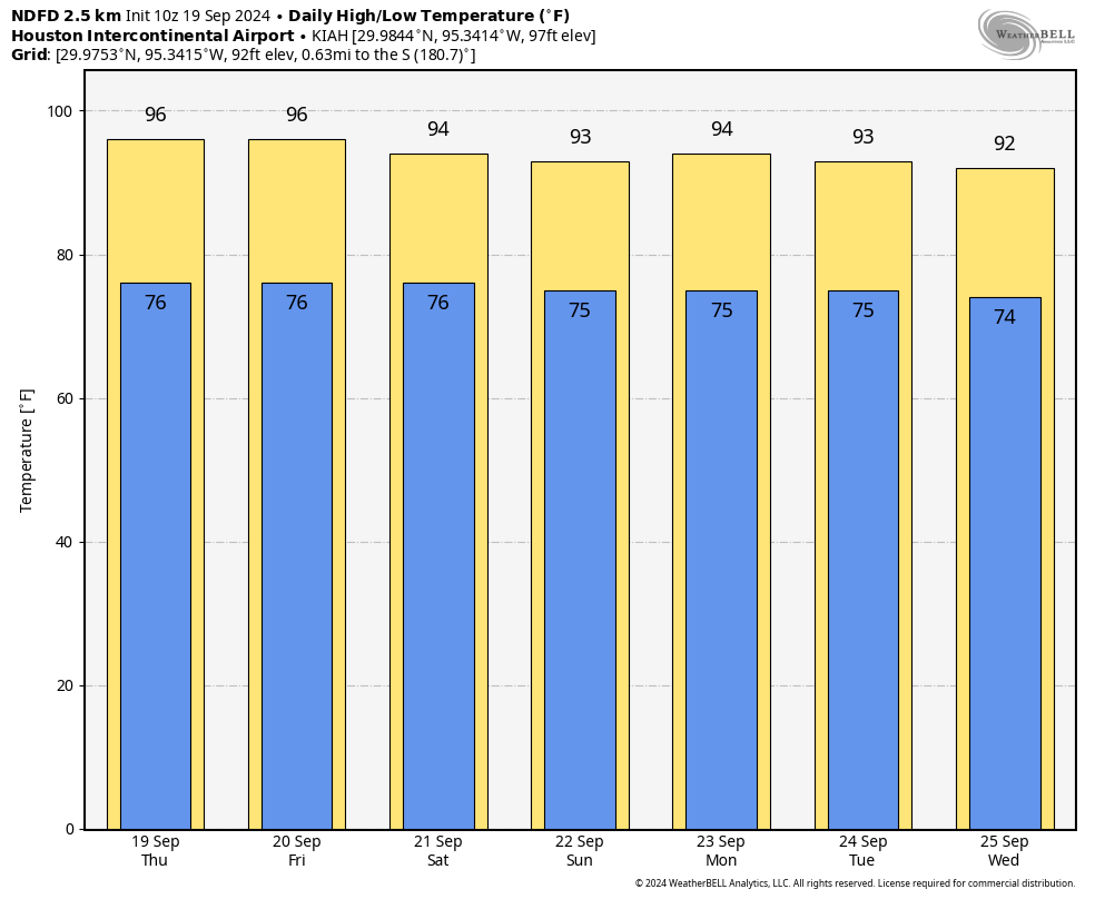
If you came to this forecast hoping to see some immediate change from the heat we’ve seen of late, you’re out of luck. For the last six days Houston has recorded high temperatures of 96 or 97 degrees at Bush Intercontinental Airport, and that trend is going to continue through the end of the work week. We are looking at high temperatures generally in the mid-90s the next couple of days, with slightly higher readings further inland, and slightly cooler near the coast. Skies will be mostly sunny, winds will be light, and nights warm. We did see some isolated showers pop up near downtown on Wednesday, so while rain chances are very low, they’re not zero. We’re looking at 5 to 10 percent chances of a rogue shower, probably.
Saturday and Sunday
More sunshine, but as high pressure starts to weaken we should see slightly cooler daytime temperatures. Much of the Houston region will probably be in the low- to mid-90s during the daytime, with nighttime temperatures falling into the mid-70s. There is a slight chance of some rain showers near the coast. The bottom line is that if you have weekend plans outdoors, you should be good to go—with proper hydration.
Next week
Here’s where things begin to get a little more interesting. High temperatures will start the week in the lower-90s, but as high pressure backs off even further we’ll see the atmosphere open up a little more to the potential for some rainfall. We’re still probably talking only 20 to 30 percent chances each day, but there will also be some clouds mixed in with the sunshine.
By Thursday or Friday there is a chance that a weak front pushes into the Houston area. At this point it’s difficult to be sure this happen, but my sense is that we’ll see a very slight reduction in temperatures and some slightly lower humidity. A stronger push of cooler and drier air could happen next weekend, which may drop nighttime lows down into the low- to mid-60s. This is far enough out that I don’t have super-high confidence in this scenario, but there is a fair amount of support in the ensembles at this point. Fingers crossed.
Tropics
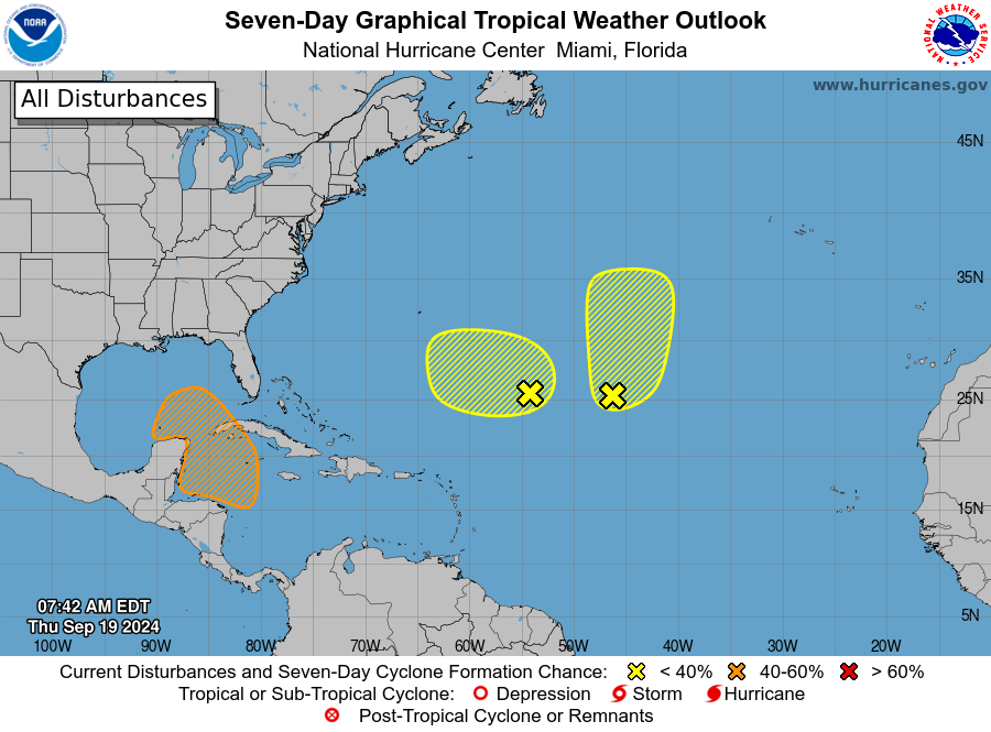
The National Hurricane Center has increased the likelihood of a tropical depression or storm forming in the Caribbean Sea during the next seven days to 40 percent. This is the area we’ve been talking about for several days now. It’s likely that something will eventually develop, but whether it stays mired in the Bay of Campeche, or eventually lifts north into the Gulf of Mexico remains an open question. Where it goes will, to some extent, be determined by the fronts I discussed above. Matt did a nice job of discussing this uncertainty, and why we just don’t have confidence in any scenario, here. The only thing to do is continue to watch it, and not get fixated on any single model run. They’re still bouncing around like crazy.
Note
I wanted you to know that I’ve got a new book coming out next Tuesday. I’m mentioning it here because I worked really hard to write a compelling tale. REENTRY tells the story behind the story of SpaceX’s Falcon 9 rocket—from its first launches, landings and failures, to ultimate success—as well as the Dragon spacecraft. You can buy the book anywhere, but if you want a signed and personalized copy you’ll need to order from a Houston-based store, Blue Willow Bookshop, by Friday afternoon. Here’s the link.

Crazy bouncing models – that’s about right.
Rooting for the cool fronts!
You had me at, “low- to mid-60s.”
I agree with Rinkos: seeing “low to mid 60s” as forecast lows next weekend is a reason to keep living.
Our 5-month summer needs to end early, even if it is just a few days.
I have pre-ordered “Re-entry”; I had been hoping for a sequel to “Liftoff” and am greatly looking forward to this read!
I am betting on a SpaceX book “trilogy” or “quadrology” by you given the rapidly evolving private space flight sector
Just curious, is it self-published?
Congratulations on your book!
This isn’t exactly weather related, but do you have any idea when the ragweed might stop trying to suffocate us?
I knew there was a reason my eyes have been burning/nose running all week! Dang it!
Congratulations on your book! I admire a meteorologist who isn’t afraid to say he’s “just not sure”. I count on you to tell the truth, whatever it is. One thing I’m sure of and you can count on is Blue Willow is the best bookstore in Houston. They’ll do up a perfect book event for you. Well done, you!
Congrats on your book. That is awesome.
Congrats on the book! I ordered a signed copy yesterday for my daughter. She works in the Aerospace industry and has had a hand in various sections of Artemis ll and lll. I’m sure she’ll find it fascinating!
Congratulations on the book! And I love Blue Willow 🙂
The book is under the wrong Eric Berger on Goodreads…in case you want to fix it somehow?!
1/8″ rain last night around 6:30 in west Houston. Quite dramatic while is lasted.
Congrats on the book! Will you be doing an in person event at Blue Willow?
Congrats on the book!
I see on the 12z gfs model two canes hitting the same general area, one within a couple of days of the other..Crazy! I’d love to read some discussion on that, even though it’s a very isolated one time model run….